interkriti®
YOUR GATEWAY TO CRETE
HOME
CRETE FACTS
NAVIGATE
EXPLORE

Agia Galini
Triopetra
Kissamos
Chryssi Isl.
Agia Marina
Balos
Gavdos isl.
Georgioupolis
SAMARIA
IDA Mtn
Palaiochora
Agia Roumeli
Sfakaki
Bali
Kalamaki
Matala
Lassithi
Plateau Lendas
Tsoutsouros
Vianos
Myrtos
Sfakia
Plakias
Ierapetra
Makrygialos
ZAKROS
Vai
Sitia
Agios Nikolaos
Elounda
MALIA
Hersonissos
Gouves
Chania
Rethymnon
Heraklion
GORTYN
FESTOS
KNOSSOS
|
|
Crete
: Geography & Nature
List Grid Map
Found
9
- Showing :
1 - 9
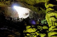 Psychro, Lassithi Plateau The cave of Psychro is one of the most important cult places of Minoan Crete. The excavators and several scholars identify the cave as the famous "Diktaian Cave", where Zeus was born and brought up with the aid of Amaltheia and the Kouretes, and which is connected with myths as this of the seer Epimenides who "slept" here, or the coupling of Zeus with Europa.
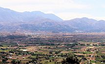 Lassithi, Dikti Mountains The Lassithi Plateau (GR: Οροπέδιο Λασιθίου, Oropedio Lasithiou), is a high endorheic plateau, located in eastern Crete, Greece on the mountain range of Dikti at an average altitude of 840 m, and in a distance of around 55km from Heraklion and 50km from Agios Nikolaos. The plateau is elliptical in shape with an E-W axis of 11km and the N-S of 7km. The plateau of Lassithi is renowned for its exceptional agricultural produce, the thousands (almost 15000) windmills that used to be there in the past, its significant historical role and for the unique cave of Psychro also known as "Diktaion Andron". Image Library
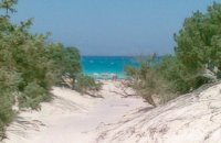
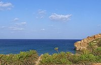 Sitia, East Lassithi A palm tree forest stretching on a marvelous valley and sandy beach. It consists of self planted palm trees of Theophrastus (Phoenix Theophrasti). It is unique of its kind in Greece, Europe and probably the world. Vai because of its special value and beauty is protected by the Greek state, European Union and international contracts. The protected area covers 23.4 ha. The sandy beach of Vai is amongst the most beautiful in Crete and Greece and attracts thousands of visitors every year since Vai is a top destinations especially for the new comers. The small islets opposite the beach add a lot to the beauty of the place. There is a parking area, a tavern, a canteen, umbrellas and seabeds. There is regular public bus connection with the towns of Sitia and Palaikastro during the summer and many organised day trips by travel agencies. If you don't like crowds, you can walk a little to the south from Vai to Psili Ammos a lovely small beach with fine gold sand which is nested in a small cove. Image Library
 Ierapetra A picturesque uninhabited small island of cedar forest, tempting golden beaches and the well preserved old church of Agios Nikolaos, only 8 miles off the port of Ierapetra, to the south. From the middle of May to the end of October, there are daily boat cruises to Chrissi island, departing from Ierapetra and Makrygialos. There is a bar restaurant at the south beach and a beach bar at the northern beach also known as "Golden Beach". The island belongs to the NATURA network due to its rare combination of ecosystems which form the habitats of several endemic species.
Image Library
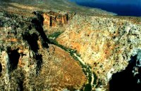 Zakros, Sitia, East Crete Within a few distance from the town of Zakros, starts the Gorge, which ends at the bay of Kato Zakros, almost near the Palace area. This gorge is of outstanding beauty, with large caves in its walls. In those caves were discovered tombs dated to the Minoan period, and finds of great archaeological importance. That is the reason why the caves are named "The Caves of Dead" and the gorge "The Gorge of Dead". Because of its natural beauty and archaeological significance the gorge attracts numerous visitors every year. Image Library
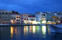 Agios Nikolaos, Lassithi Lake Voulismeni (Gr: Λίμνη Βουλισμένη) or just "the Lake" for the locals, is located at the centre of the town of Agios Nikolaos. It has a circular shape of a diameter of 137 m and depth 64 m. The lake connects to the harbour of the town by a channel dug in 1870. A panoramic view of the lake can be seen from a small park situated above it. According to legend, the goddess Athena bathed in it. Every year at midnight turning to Orthodox Christian Easter day, the majority of the population of the town gathers around the lake to celebrate with fireworks, and firecrackers. It was reported that the German army during their withdrawal from the area at WW2, disposed parts of their weaponry and/or vehicles into the deep lake. A local urban legend has it that the lake is bottomless. That notion is potentially based on its impressively disproportional high depth compared to its width (64m depth on only 134m width) or/and on locals noticing disturbances at the surface or also the level of the water during the Santorini (Thera) earthquake of 1956. Because of the latter, many assume a possible geological relation of the two locations, but this claim has not been substantiated by known scientific surveys to date. Image Library
 Selinari, Vrahassi Near the beautiful village of Vrahasi there is the imposing gorge of Selinari, formed by the mountain of Anavlohos (625 m) to the north and the mountain Fonias o Detis (818 m) to the south. The symbol of Crete, the Cretan wild goat (Agrimi or kri-kri) and the Griffon Vulture are two rare species that used to reside in the gorge. The authorities in Vrahasi intend to establish a center of protection of the local fauna and flora at the gorge of Selinari and to develop a wildlife station, to provide observation of the Griffon Vulture colony at the east side of the gorge of Selinari. The hunting is forbidden in an area covering 10 sq.km. around the gorge.  Ierapetra, Lassithi A monument of natural beauty that attract a lot of local and foreign visitors. The gorge of Sarakina (GR: Σαρακίνα) is one of the most beautiful in Crete. Its steep, vertical walls in some parts reach a height up to 250 m. Its widest opening is no more than 15 metres while in some places it’s so narrow that its sides seem to join each other. Its rich flora and fauna, the dittany, the wild birds that nest there, the running water make the route through the gorge a worthwhile experience. 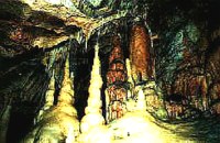 Zakros, Sitia, East Crete The cave, with impressive stalagmites and stalactites, is located near the sea (~200m), at Pelekitá (GR: Πελεκητά), a place 3km away from the Palace of Zakros (~1 hour walk)and above the small bay of Karoumbi. In this cave were discovered signs of neolithic habitation. Its entrance is at 105m above sea, it is 310m long and its area is approximately 4.500m2. A little further there was found also the quarry from where the ancients took the stones to built their Palace (hence the name "Pelekita"). The cave is also known as "Sikias Spilios" (the fig tree's cave) due to the fig tree that is located at its entrance. The view to the sea from there is magnificent.
1
|
||
|
| ||


C
O
N
T
E
N
T
S
O
N
T
E
N
T
S