interkriti®
YOUR GATEWAY TO CRETE
HOME
CRETE FACTS
NAVIGATE
EXPLORE

Agia Galini
Triopetra
Kissamos
Chryssi Isl.
Agia Marina
Balos
Gavdos isl.
Georgioupolis
SAMARIA
IDA Mtn
Palaiochora
Agia Roumeli
Sfakaki
Bali
Kalamaki
Matala
Lassithi
Plateau Lendas
Tsoutsouros
Vianos
Myrtos
Sfakia
Plakias
Ierapetra
Makrygialos
ZAKROS
Vai
Sitia
Agios Nikolaos
Elounda
MALIA
Hersonissos
Gouves
Chania
Rethymnon
Heraklion
GORTYN
FESTOS
KNOSSOS
|
|
Crete
: Sightseeing
List Grid Map
Found
28
- Showing :
1 - 20
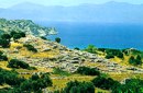
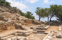
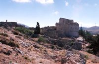
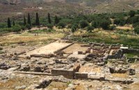 Sitia, East Crete Like the other Cretan palaces, the palace of Zakros, was first built in about 1900 B.C. The present ruins seen by the visitor belong to the second building phase, in about 1600 BC. The total area of the palace, including ancillary buildings, is approximately 10,000 sq.m. It was not only the permanent residence of the royal family, but also the administrative, as well as commercial and religious centre of the surrounding area. The long term excavations have yielded over 10,000 objects, many of them considered unique, which are now on display in the Iraklion and Sitia museums. Image Library
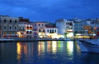
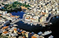 North East Crete, Lassithi Agios Nikólaos (GR: Αγιος Νικόλαος), with 9.500 inhabitants, is the capital of the Lassithi province of Crete. It is built around a picturesque lake at the north-western side of the Mirabello bay, the biggest bay in Crete. Major administrative, cultural and communications center, Agios Nikolaos is one of the most developed tourist areas, not only in Crete but in Greece in general. Thanks to the beautiful coasts, the great sights and the cosmopolitan life, this lively city hosts every year thousands of visitors without losing one bit of its tranquility and traditional hospitality.
Image Library
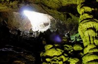 Psychro, Lassithi Plateau The cave of Psychro is one of the most important cult places of Minoan Crete. The excavators and several scholars identify the cave as the famous "Diktaian Cave", where Zeus was born and brought up with the aid of Amaltheia and the Kouretes, and which is connected with myths as this of the seer Epimenides who "slept" here, or the coupling of Zeus with Europa.
 Agios Nikolaos, Lassithi Lake Voulismeni (Gr: Λίμνη Βουλισμένη) or just "the Lake" for the locals, is located at the centre of the town of Agios Nikolaos. It has a circular shape of a diameter of 137 m and depth 64 m. The lake connects to the harbour of the town by a channel dug in 1870. A panoramic view of the lake can be seen from a small park situated above it. According to legend, the goddess Athena bathed in it. Every year at midnight turning to Orthodox Christian Easter day, the majority of the population of the town gathers around the lake to celebrate with fireworks, and firecrackers. It was reported that the German army during their withdrawal from the area at WW2, disposed parts of their weaponry and/or vehicles into the deep lake. A local urban legend has it that the lake is bottomless. That notion is potentially based on its impressively disproportional high depth compared to its width (64m depth on only 134m width) or/and on locals noticing disturbances at the surface or also the level of the water during the Santorini (Thera) earthquake of 1956. Because of the latter, many assume a possible geological relation of the two locations, but this claim has not been substantiated by known scientific surveys to date. Image Library
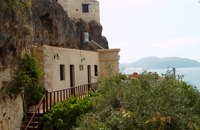
 Pahia Ammos, Ierapetra Gournia lies on a small hill, a few hundred metres from the sea in the Gulf of Mirabello, close to the north end of the Ierapetra isthmus ( 2 Km from Pachia Ammos village & 19 Km from Ag.Nikolaos). Gournia - the ancient name of which is not known - is the most characteristic of the excavated medium-size settlements, dated to the period of the peak of the Minoan culture (Late Minoan I period: 1550-1450 B.C.). It is called "Pompeii of Minoan Crete" because of the good state of preservation. It occupies a low hill, close to the sea, at the Isthmus of Ierapetra. 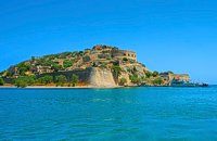 Elounda, Mirabello bay, Lassithi The island of Spinalonga (Gr: Σπιναλόγκα), officially known as Kalydon (Καλυδών), is located in the Gulf of Elounda in north-eastern Crete, in Lasithi prefecture, next to the town of Elounda. The official Greek name of the island today is Kalydon. Originally, Spinalonga was not an island, it was part of the island of Crete. During Venetian occupation the island was carved out of the coast for defense purposes and a fort was built there. A popular name for the island since Venetian rule is Spinalonga. During Venetian rule, salt was harvested from salt pans around the island. The island has also been used as a leper colony. Spinalonga has appeared in novels, television series, and a short film.
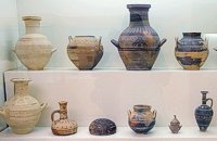
 Sitia town Rich displays cover the periods 3500 B.C to 500 A.D. The oldest artifacts come from the wider region of Sitia. The museum is divided into five chronological parts and displays include a valuable collection of vases, clay tablets in Linear A script which were found in the archives at Zakros, figurines from peak sanctuaries, a wine press from the neo-palatial period and a Hellenistic wheat mill. Of special interest is the ivory and gold male figurine which was found in Roussolakkos near Palekastro.
 Sitia, East Lassithi A palm tree forest stretching on a marvelous valley and sandy beach. It consists of self planted palm trees of Theophrastus (Phoenix Theophrasti). It is unique of its kind in Greece, Europe and probably the world. Vai because of its special value and beauty is protected by the Greek state, European Union and international contracts. The protected area covers 23.4 ha. The sandy beach of Vai is amongst the most beautiful in Crete and Greece and attracts thousands of visitors every year since Vai is a top destinations especially for the new comers. The small islets opposite the beach add a lot to the beauty of the place. There is a parking area, a tavern, a canteen, umbrellas and seabeds. There is regular public bus connection with the towns of Sitia and Palaikastro during the summer and many organised day trips by travel agencies. If you don't like crowds, you can walk a little to the south from Vai to Psili Ammos a lovely small beach with fine gold sand which is nested in a small cove. Image Library
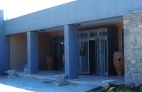
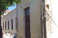 Ierapetra town, South Lassithi The museum was founded at the end of the 19th century, during the Turkish occupation of Crete and was housed in several buildings in the past. Today it is housed in the building of the Commercial Ottoman School, which is protected by a preservation order. The collection includes findings from the broader area and from the Minoan to the Roman period. Among the items are painted sarcophagi, lamps, vases, figurines, relief plaques. One of the most important exhibits of the museum is the Clay sarcophagus dated to 1450-1400 B.C.
Image Library
 Mirabello, Lasstithi Lato (Gr: Λατώ) was an ancient city of Crete, the ruins of which are located approximately 3 km from the small town of Kritsa. The Dorian city-state was built in a defensible position overlooking Mirabello Bay between two peaks, both of which became acropolises to the city. Although the city probably predates the arrival of the Dorians, the ruins date mainly from the Dorian period (fifth and fourth centuries BC). The city was destroyed ca. 200 BCE, but its port (Lato Etera or Lato pros Kamara), located near Agios Nikolaos was in use during Roman rule. There is some suggestion that the city was named after the goddess Leto (of which Lato is the usual Doric form) and may be mentioned in Linear B tablets as RA-TO. Lato also minted coins in antiquity,[3] bearing the likeness of the goddess Eileithyia who appears to have been the one particularly worshipped at Lato. Nearchus, admiral of Alexander the Great, was born at Lato. 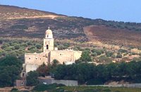 Sitia It is an historical monastery of the 15th century, which collapsed in the earthquake of 1612 and was rebuilt with the financial aid of the Venetians. During the Ottoman conquest of Crete, the monastery was destroyed and devastated by the Turks. In 1704 the monastery was declared stauropegion. During the Ottoman occupation there was a school in the monastery, while, after 1870, it was founded there a school of mutual teaching. The Monastery is a stauropegion fortress. The main building of 800 m2 has three floors, which are divided into cells, guest - houses, kitchens, the abbot' s residence and warehouses. The katholicon is a two-aisled church; the northern aisle is dedicated to the Virgin, and the southern posterior aisle, to St John the Theologian. The monastery' s characteristic bell tower bears relief crowns and crosses with inscriptions and the date 1558. In the Monastery, there is also an interesting Museum.
Image Library
 Agios Nikolaos, Lassithi The Archaeological Museum of Aghios Nikolaos is one of the most important in Crete and has been in operation since 1969. It houses collections of very important archaeological finds from the whole of Eastern Crete, an area extending from Malia as far as Zakros. These are displayed in chronological order from the Neolithic period (5700 - 2800 B.C.) to the end of the Roman times (100 B.C. - 400 A.D.) Its showcases include more than 1350 vases from the 3rd millennium B.C. as well as gold and copper finds (the most ancient found in Crete).
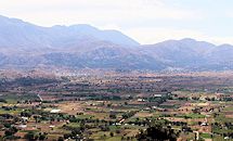 Lassithi, Dikti Mountains The Lassithi Plateau (GR: Οροπέδιο Λασιθίου, Oropedio Lasithiou), is a high endorheic plateau, located in eastern Crete, Greece on the mountain range of Dikti at an average altitude of 840 m, and in a distance of around 55km from Heraklion and 50km from Agios Nikolaos. The plateau is elliptical in shape with an E-W axis of 11km and the N-S of 7km. The plateau of Lassithi is renowned for its exceptional agricultural produce, the thousands (almost 15000) windmills that used to be there in the past, its significant historical role and for the unique cave of Psychro also known as "Diktaion Andron". Image Library
 Sitia, East Lassithi The settlement of Voila (GR: Βόϊλα) is 1km away from the village of Handras. It is a medieval deserted village protected by the Greek Archaeological Authorities. Passing through the village's alleys you can still see the ruins of old houses and their rooms, their venetian features and through this sacred silence of the place you have the impression that you hear the Byzantine king, the medieval knight or the Turk fighter gallop away. The name of the village probably comes from the Byzantine word VOILAS or VOLIAS meaning the nobleman, the land owner. In a census carried out by Kastrofilaka in 1583, the village of Voila had a population of 301. Many elements show that the village belonged to the venetian family of Zenos which during the Turkish occupation adopted the Ottoman religion and was renamed.The tradition says that he was the owner of a Castle in Voila which has an external inscription with the date 1153 equal to 1742 of the Christian diary. At the south of the castle there is a ruined church known as the church of Ginali. Other attraction at the area is the old painted church of St. George dated back to the 15th century. From the inscription it is obvious that there is a family tomb of Salamons. The Solomons of the island of Zakynthos where our national poet Dionisios Solomos comes from, are believed to having been descended from the Salamons of Sitia. At the top of the hill overlooking the village there is a fortress dated back to the Venetian occupation of the island of Crete. Image Library
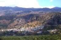 Mirabello, Lasstithi Kritsa is one of the most picturesque towns in Crete, built amphitheatrically on a rock hill. It is located 11 km from Agios Nikolaos and has 2000 inhabitants. The people keep the old Cretan customs and the traditions and the town is considered one of the most important centers of the Cretan folk and weaving art.
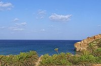
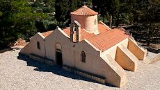 Mirabello, Lasstithi The Panagia Kera of Kritsa, as it is called the Temple of the Virgin Mary (Kera), is 1 km to the north of the village of Kritsa in Merabello Lassithi, in a place called Logari, right on the road from Agios Nikolaos to Kritsa. The history of the church of Panayia Kera begins at least since the 13th century. 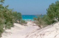 Ierapetra A picturesque uninhabited small island of cedar forest, tempting golden beaches and the well preserved old church of Agios Nikolaos, only 8 miles off the port of Ierapetra, to the south. From the middle of May to the end of October, there are daily boat cruises to Chrissi island, departing from Ierapetra and Makrygialos. There is a bar restaurant at the south beach and a beach bar at the northern beach also known as "Golden Beach". The island belongs to the NATURA network due to its rare combination of ecosystems which form the habitats of several endemic species.
Image Library
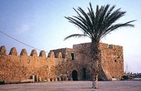 Ierapetra town, South Lassithi The fort, built by the Venetians and Known to Ierapetrans as the "Kalés" (GR: Καλές), has been erected on the top of the southernmost mole of the ancient harbour. It is one of those monuments of the past which, because of its solid construction and the fact that it was still garrisoned until the latest years of the last century, still exists today to serve as a reminder of some of the nation's most difficult times.
Image Library
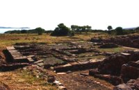 Sitia, East Lassithi At the northernmost edge of the eastern coast of Crete lie the ruins of a settlement which flourished during the Late Minoan period (1550-1220 B.C.). At the same site, however, are preserved remains of the Early and Middle Minoan periods (3000-1550 B.C.), mostly cemeteries with well-built ossuaries, and ruins of spacious houses. The site ceased to be inhabited at the same time when Zakros was abandoned (1450 B.C.) but was reoccupied during the Late Minoan III period (1300-1200 B.C.). The city covered a total area of more than 50,000 sq.m., was densely inhabited but not fortified. To the NE of one of the city's sectors lies the sanctuary of Diktaian Zeus, which belonged administratively to the city of Itanos. Cult practice was continuous from the Geometric period (8th century B.C.) until the Roman conquest. It seems that the sanctuary was plundered and destroyed by fanatic Christians at the end of the 4th century A.D. Image Library
 Sitia, East Lassithi The Monastery of Kapsa is located 40 km from the town of Sitia at the exit of the Pervolakia Gorge built against the steep rocks overlooking the Libyan sea. The exact time of the foundation of the monastery is still unknown, while some believe that it was in the 15th century. Until 1841 there were only a small chapel dedicated to the Saint John the Baptist and a few cells. Image Library
|
||
|
| ||


C
O
N
T
E
N
T
S
O
N
T
E
N
T
S