interkriti®
YOUR GATEWAY TO CRETE
HOME
CRETE FACTS
NAVIGATE
EXPLORE

Agia Galini
Triopetra
Kissamos
Chryssi Isl.
Agia Marina
Balos
Gavdos isl.
Georgioupolis
SAMARIA
IDA Mtn
Palaiochora
Agia Roumeli
Sfakaki
Bali
Kalamaki
Matala
Lassithi
Plateau Lendas
Tsoutsouros
Vianos
Myrtos
Sfakia
Plakias
Ierapetra
Makrygialos
ZAKROS
Vai
Sitia
Agios Nikolaos
Elounda
MALIA
Hersonissos
Gouves
Chania
Rethymnon
Heraklion
GORTYN
FESTOS
KNOSSOS
|
|
Crete
: Sightseeing
List Grid Map
Found
23
- Showing :
21 - 23
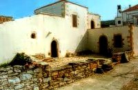 Gavalohori, Vamos, Apokoronas at 41.1km (NE) The exhibition of the objects takes place according to the contemporary museum conception, with explanatory texts, photographs, plans, models, and is enriched with new exhibits every year. The Museum is divided into seven rooms, according to the following units: The Arched House, Silk, Pottery, Lace-making, Masonry and Stone carving, Church and Woodcarving.
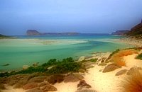 Gramvoussa Cape, Kissamos at 42.3km (NW) West of Kissamos and north of the beautiful village of Kaliviani, stretches the impressive Gramvoussa peninsula. The peninsula is formed by steep rocks and is covered with thyme and origanum bushes and wild flowers. On the north west side of the peninsula opposite to the island of Gramvoussa is the wonderful beach of Balos (GR: Μπάλος). The beach is covered with fine white sand and is located between the two creeks of the Tigani cape. The same white sand covers the bottom of the sea and grants to the sea an emerald color. In front of the beach is the picturesque island of Gramvoussa and on the back is the Geroskinos mountain (altitude 762 m). The road from Kaliviani is well paved dirt road, with amazing view to the steep rocky seaside of the east side of the peninsula. The road ends one-two km before the beach, and the visitor can follow a paved road to Balos. North of Balos, at the Korykon cape, are the ruins of the small Roman city of Agnion, with a temple of the God Apollo. There are small boats, offering daily cruises to Balos and Gramvoussa, departing from Kissamos (Kastelli) during the summertime. Image Library
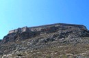 Gramvoussa Cape, Kisssamos at 45.2km (NW) Due to its strategic location, Gramvoussa was fortified by the Venetians, who built a well-fortified castle on the top of a steepy rock at an altitude of 137 m. Construction on the castle of Gramvoussa started in 1579 and ended in 1582.
|
||
|
| ||


C
O
N
T
E
N
T
S
O
N
T
E
N
T
S