interkriti®
YOUR GATEWAY TO CRETE
HOME
CRETE FACTS
NAVIGATE
EXPLORE

Agia Galini
Triopetra
Kissamos
Chryssi Isl.
Agia Marina
Balos
Gavdos isl.
Georgioupolis
SAMARIA
IDA Mtn
Palaiochora
Agia Roumeli
Sfakaki
Bali
Kalamaki
Matala
Lassithi
Plateau Lendas
Tsoutsouros
Vianos
Myrtos
Sfakia
Plakias
Ierapetra
Makrygialos
ZAKROS
Vai
Sitia
Agios Nikolaos
Elounda
MALIA
Hersonissos
Gouves
Chania
Rethymnon
Heraklion
GORTYN
FESTOS
KNOSSOS
|
|
Crete
List Grid Map
Found
83
- Showing :
41 - 60
 Akrotiri, Hania At a time that living organisms are disappearing at an alarming rate, especially through habitat destruction, the Park for the Preservation of Flora and Fauna of the Technical University of Crete, which extends to 30 hectares, constitutes a small but important area where native plants and co-existing animals are protected and can develop without human intervention. Up to now 250 different plant species that grow naturally in habitats of the Park have been identified, while their systematic documentation is still in progress. The development of new ecological units (“habitats”) began in areas of the Park that have been cultivated in the past. These will include plant species of Crete that do not grow naturally in the Park. Two such units, the wetland and the coastal habitats have already been launched. www.park.tuc.gr/ 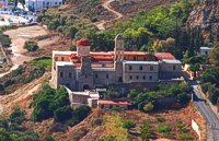 Kolimbari, Kissamos The monastery of Gonia (GR: Μονή Γωνιάς) or Panagia Odigitria, is located 1 km north of Kolimbari (along the Spatha penninsula) and 24 km from the city of Chania in a wonderful place with a magnificent view to the bay of Hania. It was built in the 17th century, in the Venetian fortress style, and it is dedicated to the Assumption of the Virgin. The monastery replaced an older, 13th-century structure, which was located on the territory of an adjacent cemetery. 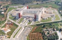 Mournies, Hania Agios Georgios" the General Hospital of Hania. Situated in the outskirts of the city of Chania, near Mournies village. It was established in 2000 and has a capacity of 450 beds. Its fundamental aim is the provision of high quality health services to all citizens, within a friendly and humane environment.
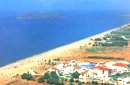 Gerani On the old road from Hania to Kissamos, 14km away from Hania is the coastal settlement of Kato Gerani which extends from the Platanias bridge to the village Pirgos Psilonerou. Awarded every year with the Blue Flag, the beach is organized and provide quite a lot facilities such as sun beds, umbrellas, shower, W.C. and sea sports. It is worth to take a small walk to the villages of the area, and enjoy the unspoiled Cretan nature and hospitality. Pano Gerani, Modi, Loutraki, Manoliopoulo are all within a distance no longer than 10 kilometrs.
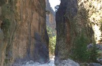 Samaria National Park Pórtes (GR: Πόρτες - Gates) or Sideróportes (Iron Gates) is maybe the most striking point of the canyon. Here the canyon walls rise nearly 300 meters while the width is only 3.5 m. At this point the water runs almost all year round. The stratified limestone, the dominant rock of the canyon, forms specific geological formations, showing all the geological history of the canyon in the eyes of connoisseurs. Portes are 11 km away from the entrance of the Samarian gorge at Xylóskalo and 4km from the beach at Agia Roumeli.
Image Library
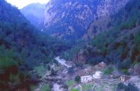 Samaria National Park The deserted village of Samariá (GR: Σαμαριά) is located in the middle of the gorge of Samaria, 7.5 km away from Xyloskalo and 8.5km fro Agia Roumeli. This is the main resting point for the gorge walkers coming down from Omalos. There is a fountain with fresh drinkable water from the spring, benches and some tables, in the shade of tall plane trees where the visitors can relax and have some food (Only if they carry it with them). The village of Samaria was abandoned in 1962, when the area declared a National Park. The main occupations of its inhabitants were the wood cutting and bee keeping. Opposite the village are the old olive trees cultivated mainly for the residents' own consumption. Some of the village' s ruined housed are restored and are used today by the gorge authorities. One houses the guards' post, another the doctor's office and a third - the old olive mill - houses the information kiosk of the park where the visitors can view old pictures and folk art exhibits. Kri - kris (the Cetan Ibex) make their appearance here from time to time especially the young ones which are less shy. At the village's edge lies the byzantine church of "Osia Maria of Egypt" (Osia = Saint). The name Samaria is believed that is a corruption of the words "Osia Maria" or "Santa Maria". A little before the village (coming from Xyloskalo) in a small clearing lies the small church of Agios Geórgios. Image Library
 Kissamos Sirikari (GR Σηρικάρι) is a small village located 52 km away from Hania and 14 km from Kastelli at 500m a.s.l. The name Sirikari probably comes from the profession of the first settler, who has to be a silk weaver (Sirikaris). A short ravine starts from Sirikari and ends close to Polyrinia. There is also a chestnut tree forest, the cave of the Holy Mother (Panagias), the byzantine church of Agii Apostoli, with frescoes of 14th century a monument of great importance and two old factories. 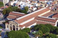 Hania town The Market, impressive for its size and shape, is built in the shape of a cross with 76 shops grouped according to their wares in the four arms of the cross. The south façade is particularly well constructed out of chiseled limestone, in the architectural style of the local tradition, developed during the Venetian period. Its construction was completed in 1913 and the formal opening was made by Eleftherios Venizelos on 4th December 1913 as part of the celebrations for the Unification of Crete to Greece.
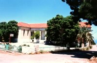
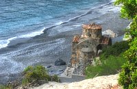 Sfakia, South Hania Ágios Pávlos (GR: Άγιος Παύλος)is a beach on the shores of Sfakiá between Agia Rouméli and Loutró. The pine trees from the high cliffs above almost reach the sea and form a unique landscape. The beach is sandy with pebbles with no facilities except for a small tavern. It can be reached only on foot ( about 1 hour walk from Agia Roumeli) or by boat. The picturesque small church of Agios Pavlos (Saint Paul) a byzantine basilica of the 10th century A.D. with frescoes, lies just a few meters from the sea. It is built with stones from the beach itself on the spot where Saint Paul reportedly baptised people on his way to Rome.
Image Library
 Omalos, Hania Xylóskalo (Ksyloskalo GR: Ξυλόσκαλο) is the point where the Samarian gorge starts. It is located on the Lefka Ori (White Mountains) in the plateau of Omalos, 43 km from the city of Hania at 1250m above sea level. It is also the entrance to the gorge. There are two tourist lodges where visitors can rest and have food or coffee and take panoramic pictures of the gorge and the White Mountains. There is also the information center of the National Park and a parking area. Xyloskalo means the "wooden stair" and refers to a wooden staircase built by the locals in order to facilitate the entrance to the gorge as at this point the cliffs are very steep. Today this part of the path is made of stones and it has a wooden handrail. About 1km before Xyloskalo a dirt road leads, after 5 km, to the Kallergis mountain lodge at 1680m a.s.l. 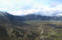 White Mountains, Hania The famous - mainly due to the gorge of Samaria- plateau of Omalos (GR: Ομαλός) is surrounded by the high crowns of the Lefka Ori (White Mountains) at 1,040 to 1,250 meters and is just 38 km from the town of Chania. It extends to the counties of Sfakia, Selino and Kydonia in the prefecture of Hania. Its shape is nearly rectangular with a perimeter of about 25kms and a diameter of approximately 4 kms. It can be reached by car from the north (Neratzoporo) and from the south (Agios Theodoros).
 Kissamos west coast Platanos (GR: Πλάτανος = plane-tree) is located 10 km from Kasteli Kissamos. It is a large village, the second largest in Kissamos area, after Kasteli. It has approximately 1000 inhabidants, which are occupied mainly in green house and olive cultivation and tourism. There is a doctor's office, gas stations, many shops, rooms for rent and taverns. At the village's old square stand a plane-tree with a fountain.  Kissamos The beautiful village of Kaliviani (GR: Καλυβιανή) is located in the beginning of the peninsula of Gramvoussa. The beauty of the village can be attributed to its wonderful stone houses and to the many flowers that blossom in every yard. Its people are friendly and hospitable. The tradition is alive in Kaliviani, since even today the houses are built the traditional way, with stones, by skillful technicians. 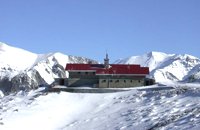 Lefka Ori, Hania Kallérgi Mountain Refuge is located on the western region of Crete, above the plateau of Omalos, in the White Mountains (Lefka Ori) mountain range at an altitude of 1680 metres. The site is of unique natural beauty and commands great views to the surrounding peaks and the gorge of Samaria. It can be accessed by car or on foot (1 1/2 hour) via the 5km long dirt road from Omalos. The refuge can accommodate up to 50 people. It features a fully equipped kitchen, a lodge with fire place and wood burning stoves, toilets (indoors and outdoors) and a camping area. Electricity is supplied by a generator. Kalergi refuge operates throughout the year (from November to March only on weekends) For more information please visit:Mountaineering Club of Hania 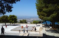 Akrotiri, Chania At the magical and historical location of Profitis Ilias, in Akrotiri, at the east of Hania lays the tomb of Eleftherios Venizelos, one of the most long-standing prime ministers of Greece and whose political life was focused on doubling the size of Greek territory and on the creation of a contemporary State. Eleftherios Venizelos himself had designated this position to be his resting place before his death. For the visitor, it affords a panoramic view of the rich green plain of Hania, the imposing White Mountains, the Cretan Sea, the town of Hania and the Chalepa quarter which is the location of the house in which the great politician spent most of his life and today is the headquarters of the National Research Foundation 'Eleftherios K. Venizelos'. Image Library
 Apokoronas, Hania Gavalohóri (GR: Γαβαλοχώρι) is an old big traditional village, with fine examples of traditional rural architecture and stone buildings that are well preserved. The village has been declared a traditional settlement and is awarded a protected status. Many interesting buildings still stand, such as the 18th century olive press, the church of Panagia (Virgin Mary) and that of Agios Sergios, the old school and the complex of the wells from the period of the Venetian occupation.
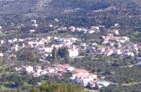
 Apokoronas, Hania The community of Kefalas (GR:Κεφαλάς) is situated in Apokoronas, Hania, approximately 4 km to the east of Vamos. During the Venetian occupation higher and lower Kefalas were classed as two separate villages, however, today they have become one. It is a large village built in an outstanding position facing the sea with architecture dominated by the influence of the early and late years of the Turkish occupation. This influence is well preserved despite the existence of other architectural styles. The church of Timios Stavros (16th century) is the oldest building of the village while the more recent churches of Panagia, Agios Antonios, and Michael the archangel, works of the reputed Kefalas craftsmen, are examples of folk architecture of the 19th century. A further example of the work of the same craftsmen is the Public School of Kefalas, which in accordance with the decision of the county council of Hania will house the Environmental Educational Centre of the prefecture, a foundation that will play a definitive role in the development of the municipality of Vamos. Other interesting communities are Paleloni and Drapanos in the direction of Kokino Horio. The road from Paleloni leads to Embrosgialo, a relatively easily accessible place, along the steep coastline, which extends to Georgioupoli. 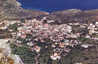 Apokoronas, Hania Kókino Horio (GR: Κόκκινο Χωρίο), which is located at a higher altitude, has maintained its traditional architectural style even more so than the other villages with its narrow roads, beautiful gates and tiled roofs. A group of cisterns, built in a sloping field, gather the rainwater, an interesting example of local architecture, dealing with the permanent problem of lack of water. Above Kokino Horio one can see the strangely shaped hill Drapanokefala or Calapodha (so named during the venetian occupation). The coastline northwest of the village is an extremely interesting place for a stroll due to the ground formation and the caves, such as the cave of Petsi (or Karavotopos). Another cave called Katalimata, located at the centre of the village, is also an interesting site. At cape Drapano, approximately 10 metres under water, is the impressive Elephant cave, an area 60mx60m full of stalactites and stalagmites of various shapes and colours. Video - The Elephants' Cave 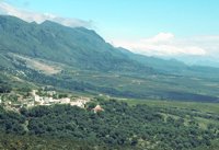 Sfakia, Hania, Crete At the exit of the ravine of Imbros, near the south coast of Sfakia. It is located at an altitude of 200 m, 68 km from the city of Hania and 4,5 km from Hora Sfakion. The area is covered with olive trees and the view to the Libyan sea and the island of Gavdos in the horizon...
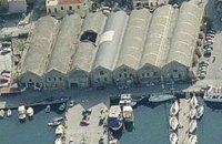 Hania, old port The south complex was completed in 1599, with the construction of 17 Neoria. Today only 7 survive out of the 17. In their original form they were open on the side of the sea. The ceilings are arched, and they are connected with arched openings of the same thickness as the walls.
|
||
|
| ||


;)
;)
;)
;)
;)
C
O
N
T
E
N
T
S
O
N
T
E
N
T
S