interkriti®
YOUR GATEWAY TO CRETE
HOME
CRETE FACTS
NAVIGATE
EXPLORE

Agia Galini
Triopetra
Kissamos
Chryssi Isl.
Agia Marina
Balos
Gavdos isl.
Georgioupolis
SAMARIA
IDA Mtn
Palaiochora
Agia Roumeli
Sfakaki
Bali
Kalamaki
Matala
Lassithi
Plateau Lendas
Tsoutsouros
Vianos
Myrtos
Sfakia
Plakias
Ierapetra
Makrygialos
ZAKROS
Vai
Sitia
Agios Nikolaos
Elounda
MALIA
Hersonissos
Gouves
Chania
Rethymnon
Heraklion
GORTYN
FESTOS
KNOSSOS
|
|
Crete
List Grid Map
Found
183
- Showing :
41 - 60
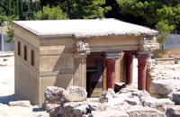 Knossos Palace at 11.7km (S) This room, located beside the north entrance, resembles a cistern. Its floor is lower than the surrounding area and is reached by steps. The "Lustral Basin" was surrounded by columns and was lined with slabs of gypsum giving it a luxurious appearance. In its present form, the area has been completely reconstructed by Evans. Areas with a similar arrangement have been found in other parts of the palace of Knossos, as well as other palaces and important Minoan buildings of the period (1700-1450 B.C.). It is not known how these places were used. However, from their construction it seems that theu would not have been filled with water, nor was there any drainage. Evans thought that they were used in purification ceremonies and therefore called these places "Lustral Basins". Evans also believed that the Palace was a sacred place. That is why, in his opinion, the "Lustral Basin"in question was used to purify visitors going into th Palace via neighbouring North Entrance. Image Library
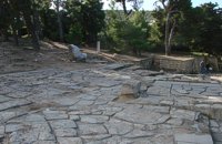 Knossos Palace at 11.7km (S) This area, sited at the north-west edge of the palace, was called the "Theatre" by Evans because its shape reminded him of later theatres. It is a platform and rows of steps that form a right angle. At the base of the stairs is the end of a narrow elevated road that crosses a paved court. Evans believed that the court was used for ceremonies watched by the standing viewers. The elevated paved road continues in the opposite direction. It passes underneath the modern road to Heraklion, connecting the Palace with the Minoan town, which extended to the West and North. Evans named the road the "Royal Road". Along the length of the road are town houses with workshops on the ground floor and residential areas on the upper floor. Image Library
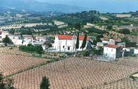
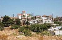 Pediada, Iraklion at 11.9km (E) Evangelismos (GR: Ευαγγελισμός) at 360 m above sea level, with 365 inhabitants, lies to the SW of Kasteli, distant only 5 km from the county town and about 35 km from Heraklion. In earlier years, the village was called Mouktari or Mouchtari and its name figures in a 1381 contract for the buying and selling of grain. The Byzantine church of the Panagia is worth a visit. On August 6th the village celebrates the feast of the Metamorphosis. Evangelismos is the seat of the newly (2010) created municipality, according to the National "Kallikratis Project", by uniting the former municipalities of Kastelli, Thrapsano and Akalochori. The name of the new municipality is "Minoa Pediada" 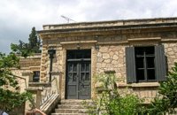 Knossos at 12km (S) Villa Ariadne was built at Knossos, Crete, by Sir Arthur Evans soon after he discovered the Minoan palace, when the site was his own private property. The villa became home, in turn, to John Pendlebury, who used it as a base for his excavations at Knossos and his explorations of the island. After Pendlebury's death at the hands of invading German paratroopers, the Villa Ariadne was taken over by General Karl Kreipe, who was living there when he was kidnapped by Patrick Leigh Fermor and his team. Ariadne villa is surrounded by the only existing Greek Edwardian garden, a large oasis of Cretan and other flora and shrubs in specific formations. The garden has been fully studied by the British School of Archaeology with the participation of special architects and agronomists from Heraklion. 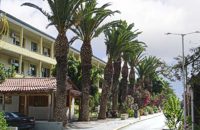 Knossou Av. Iraklion at 12.6km (N) The General Hospital of Heraklion "Venizeleio & Pananio", named after the great statesman Eleftherios Venizelos, is one of the largest hospitals in Crete with 500 organic beds. It is located 4km away from Heraklion center on the road to Knossos, and occupies an area of 25,000 sq. meters. Venizeleio hospital provides high quality health services to citizens in a friendly and human environment. It was established in 1953 by a donation of Cretans of America and worked initially for Pulmonary Diseases. It was for many years the major hospital in East Crete. Telephone: (+30) 2813 408000 Website: www.venizeleio.gr/  Pediada, Iraklion at 13km (E) 330 m above sea level, just out of Kasteli (1.5 km) to the east, lies the village of Archangelos (GR: Αρχάγγελος) with 433 residents. It was founded in 961 by the military forces of Nikiphoros Phocas and was originally named ‘Varvaro’, and was still known by that name in 1583, where the Chandax Register puts it down as a village of the Pediada district with 37 inhabitants. Its name was changed only recently, in 1961, to Archangelos, and the main village church in the square is dedicated to the Archangel Michael. There is another smaller and older church, that of the Panaghia, with Byzantine wall paintings. Remains of ancient mills can still be seen. In a location known as Trochalos, archaeological finds have brought to light a series of Minoan tools dating back to the first and second Late Minoan periods. As in every Cretan village, raki and ‘mezedes’ are always available at the kapheneions. The feast of Michail Archangelos on November 8th is celebrated with much feasting in the village. 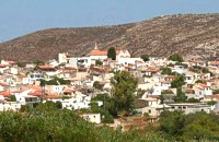 Pediada, Iraklion at 13.1km (NE) The village of Smári (GR: Σμάρι) is a traditional Cretan village, only 10 km away from Kasteli and has 375 inhabitants. In it you will find beautiful old stone houses that have been restored, picturesque little alleys, ruins of older buildings and pottery workshops where you can purchase copies of Byzantine and Minoan ceramics. There are also some interesting churches with wonderful frescoes like the one dedicated to Sotir Christos, the Koimisi tis Panagias and Agios Giorgos. The earliest reference to the village of Smari dates back to 1375. There is a lively Cretan feast on July 20th in honour of Profitis Ilias, with much rejoicing, singing and dancing. 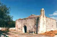 Pediada, Iraklion at 13.7km (E) At an altitude of 380m, with 63 inhabitants, Liliano (GR: Λιλιανό) is first mentioned in the Turkish census of 1671. The Basilica with its three naves, dedicated to Saint John, was built in the 12th -13th centuries and is one of the oldest and the most interesting in Crete. The stones used in its construction came from earlier buildings. The three naves, with the middle nave higher than the other two, are supported by columns in Ionic style. The narthex in front is lower with wider arches, whereas the door and windows have pointed arches. 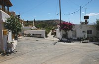 Pediada, Iraklion at 14.1km (E) Village of the area of Kastelli with 115 residents, Agia Paraskevi is situated 5 km northeast of Kastelli at an altitude of 400m. It is first mentioned in the Turkish census of 1671 as Agia Paraskevi tou Xourdou with 17 haratsia (head tax). It is very possible that Santa Venerata, a village mentioned in 1463 by Cardinal Bissarion, is the name by which Agia Paraskevi was known at that period. 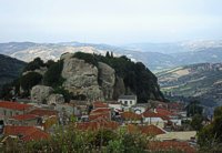 Kenourgiou, Iraklion at 14.1km (W) Agios Thomás (GR: Αγιος Θωμάς) lies at 530 m above sea level. It is 30 km away from Heraklion and has a panoramic view over the whole area to the SE of Aghia Varvara. Agios Thomas is a very old village and the first reference we have of it, is in a document of 1371, where it is quoted as a feudal property of Petrus de Medio, and again in a document dated 1380. Later, it figures in all the Venetian censi of the 16th and 17th centuries. In 1881, and in 1900, it figures as part of the Megali Vrisi municipality, with 344 inhabitants. From 1920, it figures in all the censi as a community with a continuously growing number of inhabitants. Nowadays there are over 800 inhabitants. 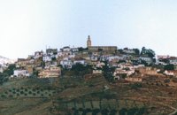 Malevizi, Iraklion at 14.3km (W) Agios Myron, with 708 inhabitants, lies 18 km from the city of Iraklion to the south west. Its one of the most important villages of the area with interesting town planning and impressive samples of traditional architecture. Built between two hills it commands a panoramic view and the school's clock, its main characteristic, is visible from almost everywhere in the area of Malevizi. 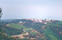 Malevizi, Iraklion at 14.3km (NW) Petrokéfalo (GR: Πετροκέφαλο) lies 16km from Iraklion and 3km from Agios Myron at 340m a.s.l with 248 inhabitants. It is built on a rocky hillside. The hill' shape resembles to a human head and it is supposed that the village owes its name to this (petrokefali = stone head) . The settlement was fortified and lately were discovered significant ancient findings. The patron Saint is "Agia Paraskevi" and there is a village feast on the 8th September in her honour.
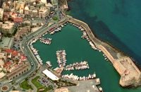 North - Central Crete at 14.4km (N) Iraklion (Heraklion or Herakleion GR: Ηράκλειον) is the largest urban centre in Crete, the capital of the region and the economic centre of the island. The first European civilisation, the Minoan civilisation, flourished on this land 5000 years ago. Currently the population of Iraklion is approximately 150.000 people. It is a very dynamic and cosmopolitan town, particularly during the summer period when thousands of visitors can be seen shopping in the market or visiting the museums and other places of interest. Today Heraklion is the top choice for tourist destinations in the Mediterranean. The city is also the commercial and scientific centre of the island. During the last 20 years the city has made remarkable progress in the academic and technological fields...
Image Library
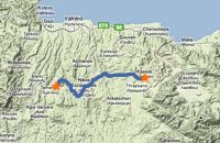 by Richard Ellis at 14.4km (E) 9th June- I rested for a day in the Kalliopi hotel, tended to my feet as best I could and tried to “carb-load” as instructed by my tri-athlete daughter...I made the decision to take as direct a route as I could towards Profitis Ilias in order to make my rendez-vous with Triantafyllos at Rouvas the following evening. This meant leaving the official E4 and bypassing Archanes and Ghiouktas and all the interesting historical stuff. Distance: 38.5 km Time: 11.5 hrs. Mov av 5 km/hr Height overnight: 175m. 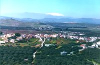 Pediada, Iraklion at 14.5km (E) Kastelli (GR: Καστέλλι) is a small town in the countryside of the province of Pediada. It has over 2000 inhabitants and provides all the modern facilities and public services its residents and/or visitors may need. Many events are organized through the year by the municipality, the school and the cultural centre. In August a special festival, known as the Feast of Xenitemenou (ex-patriot feast) includes concerts, folklore, exhibitions and theatre plays.
 Malevizi, Iraklion at 14.8km (W) Pyrgou lies 20 km from Iraklion and 1km from Agios Myron at 400m a.s.l with 354 inhabitants. It is built on a hillside overlooking the area, with panoramic view to the village of Kroussonas and the ravine of "Agia Irini". At the village's perimeter there are well maintained tower-like houses. 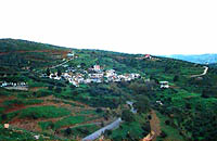 Gouves, Iraklion at 14.8km (NE) Vorou (or Voritsi) lies at a height of 230 m. above sea-level and counted 62 inhabitants in 1981 and 48 in 2001. It is 25 kms away from Heraklion. To get there, you follow the National Road to Aghios Nikolaos and at kms 17.7 turn right, taking the road Gouves-Skotino- Vorou. Nowadays it is known as Voritsi but this name is not official. The name Vorou, on the other hand, in the district of Pediados is mentioned by Barozzi in 1577. At the beginning of this century there lived a wise man and a healer in the village of Voritsi. His name was Giorgos Konstantoulakis and people flocked from all over to Crete to seek his advice.
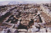 Pediada, Iraklion at 14.9km (NE) Smari has a very long history and was inhabited, according to reliable sources, from the proto-Minoan period onwards. The archeological relics in the Akropolis of the hill called Profitis Elias, excavated under the direction of the Archeologist D. Hatzi Vallianou, indicate a continuous human presence from the Middle-Minoan period to about 630 B.C. 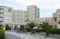 Stavrakia, Iraklion at 15km (NW) The University Hospital of Heraklion (Pa.G.N.I.) is the largest hospital facility in Crete and one of the largest public hospitals in the country. The Pa.G.N.I. provides secondary and tertiary health care in a wide range of clinical specialties, diagnostic and laboratory tests. It is located 8km away from the city of Heraklion in the area of Stavrakia, next to the School of Medicine of the University of Crete Telephone: +30 2813 402111 & 2810 392111 Website: www.pagnh.gr/  Pediada, Iraklion at 15km (E) Polythéa (GR: Πολυθέα) is located 500 m NE of Kastelli at an altitude of 335m.N Nowadays Polythea has become part of Kasteli and it has 364 inhabitants. Fr. Barozzi mentions it as Apigaiduri in 1577, belonging to the Pediada district and it continues to be known with that name until 1940, when it is re-baptized with its current name, Polythea. The previous name of the village, Pigaidouri, is originated by the word ‘pigaidi', which is Cretan for ‘pigadi', which means ‘a well'. It is a nice name that propably has been changed due to the fact that people thought it was a reference to ‘gaidouri', which means ‘donkey'. Apart from the ubiquitous raki and mezedes served at the kapheneions, you can also find rooms for rent. A typical Cretan feast is held here on August 15th for the Virgin Mary (Assumption). |
||
|
| ||


)
C
O
N
T
E
N
T
S
O
N
T
E
N
T
S