interkriti®
YOUR GATEWAY TO CRETE
HOME
CRETE FACTS
NAVIGATE
EXPLORE

Agia Galini
Triopetra
Kissamos
Chryssi Isl.
Agia Marina
Balos
Gavdos isl.
Georgioupolis
SAMARIA
IDA Mtn
Palaiochora
Agia Roumeli
Sfakaki
Bali
Kalamaki
Matala
Lassithi
Plateau Lendas
Tsoutsouros
Vianos
Myrtos
Sfakia
Plakias
Ierapetra
Makrygialos
ZAKROS
Vai
Sitia
Agios Nikolaos
Elounda
MALIA
Hersonissos
Gouves
Chania
Rethymnon
Heraklion
GORTYN
FESTOS
KNOSSOS
|
|
Crete
List Grid Map
Found
128
- Showing :
61 - 80
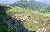 Kasteli, Pediados at 32.6km (W) The ancient city of Lyktos or Lyttos (GR: Λύκτος / Λύττος) was one of the most ancient and powerful towns in Crete. Although the excavations in the area reveal traces of habitation from the Hellenistic years onwards (630 B.C.), the archeologists Georgios Rethemiotakis and Angeliki Lempesi have excavated traces of habitation from the time of the destruction of Lyttos by the Knossians (219 B.C.) in excavated residences of the Hellenistic period. From the Roman period, the city was subject to new workings as testified by the architectural remnants and the many inscriptions and statues discovered. Numerous vestiges of ancient structures, objects, and broken marbles are seen, as well as an immense arch of a Roman aqueduct, by which the water was carried across a deep valley by means of a wide marble channel. Traces of the aqueduct which brought its water supply from Kournia, near Krasi village, are still visible today in the rural road to Kastamonitsa village. Lyktos had also a theatre, built in the slope of the hill the design of which we know only from the drawings of Belli (1586). Finally, the most important discovery is that of a room of nearly 14 metres by 11.40 metres, with marble flooring and a series of four stone platforms along its two longer sides. The room was erected, according to the inscription that was found at the site, at the beginning of the second century B.C. This room was identified as the chamber of the Roman deputies of the city and was very probably destroyed by an earthquake at 365 AD. Lyktos appears to have still been inhabited in the 7th Century AD as indicated by the excavation of late-roman shops in the area. (Late Roman Empire, 284-610 AD) 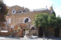 Hersonissos, Iraklion, Crete at 33.1km (NW) The Cretan Open-air Museum 'Lychnostatis' aims to promote the understanding and awareness of the Cretan folk cultural heritage. Its scope lies on the Cretan Folk Tradition and Ethnology, the Cretan Nature and Environment and the Cretan Folk Culture. Located in Hersonissos, one of the principal tourist areas in Crete, the museum is, apart from a valuable tourist asset, an exemplary self - motivated conduct on tradition, culture and environment of the island. 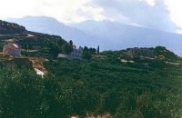 Sitia, East Crete at 33.2km (E) Etiá (or Ethiá GR: Ετιά) is a small settlement situated 2 klm away from the village of Papagianades driving to the village of Armeni. In a Venetian census was recorded with a population of 564. The village of Etia was at peak of its power around the Venetian occupation and from the presence of the St. John and St. Aikaterini churches one assumes that the village also existed through the Byzantine period as well. The village used to be private property of the De Mezzo family, a venetian family, where they built their three-storeyed house, the Seragio Serai House, which used to host Turkish officers as well during the Turkish occupation and can be seen nowadays. This House is considered to be one of the most important samples of the Venetian architecture in Crete. The church of St. Aikaterini used to be occupied by the Turks as a mosque until the Cretan revolution in 1897. At the south of village of Etia there is the hill of Etiani Kefala at an altitude of 715 m. where it used to be a sacred place but unfortunately nowadays looted. 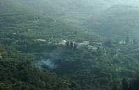 Pediada, Iraklion at 33.2km (W) A beautiful small settlement, with 48 people, Epano Karouziana (GR: Επάνω Καρουζανά) lies at an altitude of 380m and is located at 40km from Herakleion. It is mentioned for the first time in 1842, its name was taken by a family name "Karouzos" common in the village. The village offers a spectacular view, picturesque paved lanes, traditional kafeneia and taverns and is a popular with tourists, especially in the summer when many Cretan evenings are organized with local music and dance. 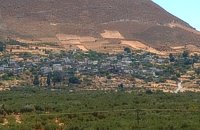 Pediada, Iraklion at 33.3km (W) Geraki (GR: Γεράκι). This lovely village of 375 inhabitants is located on the western slopes of the Lassithi mountains between the peaks of Afendi (1578 m) and Sarakinos (1588 m) in a beautiful glen, 520m above sea level and only 9km SE of Kastelli. It features an interesting Byzantine church, dedicated to the Archangel Michael (Archangelos Michail) with wall paintings that have not been maintained and some interesting (movable) icons by the local painter, Sepis. The active cultural centre of Geraki organizes many events during the summer season. Twice a year the village has a typical Cretan feast in honour of its patron saints: Agia Paraskevi on July 26th and Michail Archangelos on 8th November. The village produces agricultural products and great cheese that led to a specific cheese celebration. From Geraki you can also reach the lovely chapel of Agia Anna, driving through a particularly beautiful landscape with a spectacular view over the Geraki glen and fresh running water, a place ideal for a picnic. Image Library
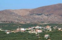
 Pediada, Iraklion at 33.3km (W) Built at 510 m with 319 people Ksidás (GR: Ξυδάς) also known as Lyttos, is located at 3 km from Kastelli in the foothills of the site of the ancient town Lyttos. The first mention of the village goes back to 1368AD, with the name Ksidas. A burial site was discovered when the road was being constructed, at Chomatolakkos, belonging to late Roman period. Two gold rings have also been found here, the one with stone, showing the portrait of an emperor holding a spear, and the other with a hoop, showing two interlocking hands. A bronze ring with a Greek inscription, along with golden plates and bronze coins, were also found at this site. Image Library
 Sitia, East Lassithi at 33.4km (SE) The Monastery of Kapsa is located 40 km from the town of Sitia at the exit of the Pervolakia Gorge built against the steep rocks overlooking the Libyan sea. The exact time of the foundation of the monastery is still unknown, while some believe that it was in the 15th century. Until 1841 there were only a small chapel dedicated to the Saint John the Baptist and a few cells. Image Library
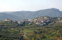
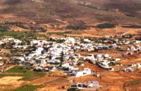
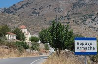 Pediada, Iraklion at 33.5km (W) Armacha (GR: Αρμάχα) lies at 490 m above sea level, at a distance of 7km from Kastelli, with 110 residents (census 2001) and is first referred to by Barozzi in 1577. Armacha is rich in the production of agricultural and livestock products. The Metropolitan Bishop, Tirnovos Voulgaria Ilarionas Kabanaris Sinitis was born, and is also buried here. A man of advanced learning, he wanted to translate the Bible to Demotic Greek. 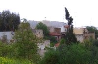 Pediada, Iraklion at 34.1km (W) Anbother beautiful small settlement, with 38 people, Kato Karouziana (GR: Κάτω Καρουζανά) lies at an altitude of 300m and is located at 49km from Herakleion and 1km from Epano Karouzana. It offers a spectacular view to the Kastelli plain, picturesque paved lanes, traditional kafeneia and taverns and is a popular with tourists, especially in the summer when many Cretan evenings are organized with local music and dance. 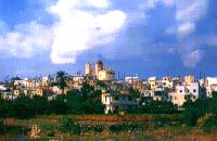 Sitia, East Lassithi at 34.2km (E) Piskokéfalo (GR: Πισκοκέφαλο), a principal village located 3 km south of Sitia. Piskokefalo is the birth place of the great poet Vincentzos Kornaros, who wrote the masterpiece of Medieval poetry, "Erotokritos". The village is mentioned at the census of 1577 by Fr. Barozzi, and became the seat of the commanding officer, after the destruction of the town of Sitia in 1538 by the pirate Chairentin Barbarossa. Nowadays Piskokefalo is a beautiful village where a stop is worthwhile. The visitor can see the house of Kornaros, enjoy a coffee or a meal at the village's square, visit the spring at Zou, the old water mill, the church of "Agia Anna" and the small chapel of "Panagia Trapezounta".  masterpiece of the Cretan Renaissance at 34.3km (E) Erotokritos (GR: Ερωτόκριτος) has been characterized as a masterpiece of the Greek language which unites the magic of myth and a deep understanding of everyday life. It expresses the "threefold ideal which is bravery, beauty and wisdom." A work rooted deeply in authentic Greek traditions, humanity, true feeling and pure love for life and freedom. The story takes place in Athens where King Herakles lives with his wife Artemis and their very beautiful daughter Aretousa, with whom the handsome and brave young man Erotokritos, son of the king's advisor, has fallen in love. After many difficulties and trials, the couple is married amidst celebrations and magnificent contests. The world of this work is the ideal Greek world of friendship, pure feelings, authentic Greek traditions. It is the world of the beauty of Athens and Crete which is "the throne of virtue and the river of wisdom." The language of this work is authentic Greek and Cretan, a synthesis and conscious effort of the poet to express lofty human feelings and values with simplicity, directness and truth. The poem was written by Vitsentzos Kornaros (1553-1613/14) a noble Cretan from Sitia with a very strong presence in Greek letters.  Cretan poet of the Greek Renaissance at 34.3km (E) Vitsentzos or Vikentios Kornáros (GR: Βιτσέντζος or Βικέντιος Κορνάρος) or Vincenzo Cornaro (March 29, 1553 – 1613/1614) was a Cretan poet of the Greek Renaissance who wrote the romantic epic poem Erotokritos. He was a leading figure of the Cretan Renaissance. Not many biographical sources exist about Kornaros himself apart from the last verses of Erotokritos. It is believed that he was born to a wealthy family in Trapezonda near Sitia, in 1553, and lived there roughly up to 1590. He then moved to Candia (present Iraklion), where he married to Marietta Zeno. Together they had two daughters named Helen and Katerina. Image Library
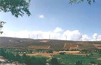 Sitia, East Crete at 34.4km (E) The picturesque hilly village of Arméni (GR: Αρμένοι) is situated at the plateau of Ziros, 27 km from Sitia through Handra and 23 km through the villages of Papagianades and Etia. It was first recorded in a venetian census in 1583 with a population of 428. Today the village has approx. 400 inhabitants. The sightseer is impressed by the numerous windmills in the area. The church of Agia Sofia which used to be one of the most important churches of the Eastern Crete is also in Armeni. Amongst its icons, the Holy Mother presents interesting art features. The Cave of Holy Spirit is also in the area of the village of Armeni. In the wider area you can also visit the Etia settlement. 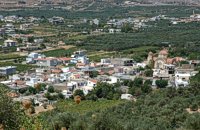 Pediada, Iraklion at 34.5km (W) Diavaide (GR: Διαβαϊδέ) has 120 inhabitants and lies very near to Kasteli (700m to the SE) at 355m above sea level. The earliest reference to the name is found in the Ducal Archives at Chandax in 1378. Another document in the same archives mentions a certain G. Dochiano, inhabitant of Diavaide. In an inscription, found in the Byzantine church of Agios Georgios Sfakiotis, the name of the village is clearly mentioned, indicating that Diavaide existed well before the Turkish occupation. In that church there is a unique fresco of Byzantine art that represents Saint George and Saint Demeter passing through the sea on their horses, while at their feet lie various sea creatures; crabs, lobsters, and other fish, a strange phenomenon indeed, considering that the village is so far away from the sea. There is also the church of Agios Nikolaos in the village dated to the same period. The village took part in all the main fights by Crete against the enemies of its freedom, while during German occupation the high college of Kastelli continued to operate in Diavaide houses. The cultural association of the village, one of the first in this area, strives to maintain the cultural traditions and the continuity of village history through the years. 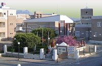 Sitia, Lassithi at 34.8km (E) The hospital provides full medical treatment and services. Website: www.ghsitia.gr Xerokamares, 72300 SitiaTel : 2843 3 40 100 FAX : 2843 0 25 352 - 2843 3 40 200 E-mail: ghsitia@ghsitia.gr 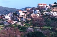 Pediada, Iraklion at 34.8km (W) Bizariano (GR: Μπιτζαριανό) is a traditional small village of about 24 inhabitants in the area of Kasteli Pediada, 320 m above sea level and about 3 km to the north of Kasteli on the road to Hersonissos. A pretty village with stone houses, graphic lanes and courtyards covered in flowers. It is first mentioned in 1881, as Bizariano, Municipality of Kasteli, with 55 Christian inhabitants. In 1951, it changes its name to Pigi. Its first name is that of a family, Bizariano. Close to the village, in a beautiful spot full of lush vegetation, evergreen plane trees and gushing water, stands the ancient church of Agios Pandeleimonas, with its three naves. Two rows of arches supported by columns without capitals separate the naves. Another column is made exclusively of capitals, apparently brought in from other churches or temples. Practically all the middle outside wall is decorated with inscriptions, Byzantine reliefs and crosses. Agios Panteleimon (External) Agios Panteleimon (External) Agios Panteleimon (interior) The artistic highlight of the church of Saint Panteleimon are its fresco scenes painted on the walls which are among the oldest in Crete, although very few frescoes remain. In the lower section of the arch, there is the representation of the three Hierarchs, shown on full length, with vertical inscriptions on it. On the two side walls there are the representations of Saints in a colossal size. These scenes were designed to be a source of biblical education to the faithful, who would have been illiterate at that time. Image Library
 Pediada, Iraklion at 34.8km (W) Polythéa (GR: Πολυθέα) is located 500 m NE of Kastelli at an altitude of 335m.N Nowadays Polythea has become part of Kasteli and it has 364 inhabitants. Fr. Barozzi mentions it as Apigaiduri in 1577, belonging to the Pediada district and it continues to be known with that name until 1940, when it is re-baptized with its current name, Polythea. The previous name of the village, Pigaidouri, is originated by the word ‘pigaidi', which is Cretan for ‘pigadi', which means ‘a well'. It is a nice name that propably has been changed due to the fact that people thought it was a reference to ‘gaidouri', which means ‘donkey'. Apart from the ubiquitous raki and mezedes served at the kapheneions, you can also find rooms for rent. A typical Cretan feast is held here on August 15th for the Virgin Mary (Assumption). 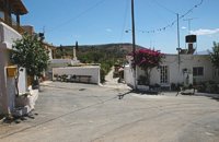 Pediada, Iraklion at 35.1km (W) Village of the area of Kastelli with 115 residents, Agia Paraskevi is situated 5 km northeast of Kastelli at an altitude of 400m. It is first mentioned in the Turkish census of 1671 as Agia Paraskevi tou Xourdou with 17 haratsia (head tax). It is very possible that Santa Venerata, a village mentioned in 1463 by Cardinal Bissarion, is the name by which Agia Paraskevi was known at that period. 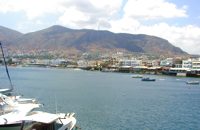 Pediada, North - East Iraklion at 35.2km (NW) The most popular tourist resort in Crete. Nice beaches, sights and facilities for all tastes and ages. Together with Malia, are the party places for young visitors. Close to Hersonissos there are three small traditional village, those of Piskopiano, Koutouloufari and Old Hersonissos.
 Sitia, East Lassithi at 35.2km (E) The village of Handras (or Chandras (GR: Χανδράς) is in the Municipality of Lefki at the Armeni-Handras plateau and 27 km from the town of Sitia. First recorded in a venetian census in 1583 as Candra and Chandra with a population of 399 like today. Ancient Minoan sites were found at the Plakalonia area as well as at the Gras and Katrani places. There is a peak sanctuary at the hill of Xykefalo between Handras and Kasteliona at an altitude of 705 m. In spite of its looting a lot of ancient objects were found. The cave of Panagia Gouda is at the Handra region. This region includes the communities of Voila, Agios Panteleimonas and Pano Panteli. At Pano Panteli there is an old church the Metamorfosis in which there is an inscription that says: Petro Abramo was here in 1486. |
||
|
| ||


)
)
)
C
O
N
T
E
N
T
S
O
N
T
E
N
T
S