interkriti®
YOUR GATEWAY TO CRETE
HOME
CRETE FACTS
NAVIGATE
EXPLORE

Agia Galini
Triopetra
Kissamos
Chryssi Isl.
Agia Marina
Balos
Gavdos isl.
Georgioupolis
SAMARIA
IDA Mtn
Palaiochora
Agia Roumeli
Sfakaki
Bali
Kalamaki
Matala
Lassithi
Plateau Lendas
Tsoutsouros
Vianos
Myrtos
Sfakia
Plakias
Ierapetra
Makrygialos
ZAKROS
Vai
Sitia
Agios Nikolaos
Elounda
MALIA
Hersonissos
Gouves
Chania
Rethymnon
Heraklion
GORTYN
FESTOS
KNOSSOS
|
|
Crete
List Grid Map
Found
102
- Showing :
61 - 80
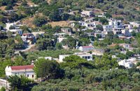
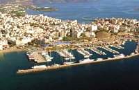 Agios Nikolaos, Lassithi at 23.6km (SE) Well protected Marina by all weather condition, build to European standards and capable to accommodating up to 255 boats all year round. The Marina of Aghios Nikolaos is located in the heart of the town, provides all the necessary facilities for a pleasant short or long stay for yacht passengers and a safe environment for the boats. Facilities: Water/Electricity:Each berth has access to a service box where fresh water and 220 / 380 volt electricity available. 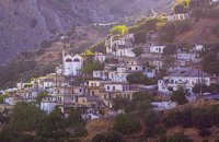 Ierapetra, Lassithi at 25.1km (S) At a mountainous, precipitous site, in the west mountain slopes of Dikti, at an altitude of 550 m above sea level and at 2 km from the village of Malles, is built the village Christos (GR: Χριστός – Christ). Christos is a beautiful, verdurous village, with many running waters, traditional, unchanged by time, with narrow sloping cobbled alleys. Image Library
 Ierapetra, Lassithi at 25.2km (S) One of the largest villages of Crete, in the north of the valley of the river Sarantapichos. It is 28 km away from Ierapetra and 40 km away from Aghios Nikolaos, in a verdurous slope within immense olive groves, with an unlimited view to the valley of Myrtos, the Libyan Sea and the mountain peaks that surround it. 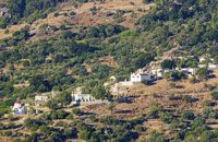 Ierapetra, Lassithi at 25.7km (S) It is a small village with few residents, loacated 4 km to the west of the village Christos at an altitude of 600 m. The residents of Metaxohori (GR: Μεταξοχώρι, or Parsás - GR: Παρσάς) have immigrated to the plains of Ierapetra, in Stomio, Ammoudares and Xerokampos and work in the glasshouses. The village has been renamed in 1955 from Parsas to Metaxohori to honor the Ecumenical Patriarch Meletios Metaxakis who was born here. 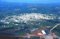 Central Iraklion at 26.1km (SW) The town of Arkalochori (GR: Αρκαλοχώρι) with a population of 2.881 is located 33km away from Heraklion, on the provincial road linking Heraklion and Viannos, at 395m above sea level. Its inhabitants are mostly involved in agriculture, but in commerce and arts as well. Arkalochori is one of the most developing towns in the prefecture of Iraklion both in economic and cultural sectors and is the administrative center of the area. Events such as the Pancretan Agricultural and Commercial Exhibition, that takes place here are of great significance and interest for the whole island. The town offers a full range of modern facilities to its residents and visitors.
Image Library
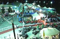 Arkalohori at 26.3km (SW) A modern exhibition and congressional centre offering 8000 square meters of total space, 1500 of them being indoors. Among many events that take place in this centre is the Pancretan Agricultural and Commercial Exhibition of Arkalochori held every two years at the end of August. The exhibition attracts a large number of enterprises, manufacturers and services participating and is being visited by over 30,000 visitors from all over Crete. It is considered to contribute essentially in the rapid commercial and cultural development of the wider area. Photo The Municipal Open Theatre Located in the area of the exhibition centre the theatre is of semicircular shape with a capacity of approximately 1000 seats. The facility offers also a canteen, toilets, dressing-rooms for the actors, store room of scene and backstage.The cultural events that the Municipality organises every summer, attract visitors not only from the wider area but also from Iraklion city. Photo Photo 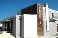 Myrtia. Iraklion at 26.5km (W) The Nikos Kazantzakis Museum is dedicated to the great Greek writer, poet and philosopher Nikos Kazantzakis. It was founded in 1983 and it is located at the village Myrtia in Iraklion, next to his father's house. The museum contains some of his personal belongings (pipes, glasses, pens, etc.) and a rich collection of his manuscripts and letters, first Greek editions of his books, documents from theatrical productions of his works, copies of TV series and movies based on his novels, portraits of Nikos Kazantzakis, copies of press releases and articles on his life and work. 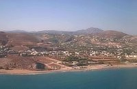 Iraklion at 27km (W) This 2 km long sandy beach was for years and still is the favorite beach of the people of Heraklion town. It is named after the river "Karteros" which outflows at the west end of it near the airport. The water is clean, the seabed is sandy with smoothly shelving and swimming is safe. The access is free in most parts except for some areas that are reserved for military personnel and the municipal beach "Akti" where visitors should pay an entrance fee in order to use the facilities. At the east end there are some very good taverns offering fresh fish among their specialties and are very popular with locals and tourists alike.
Image Library
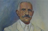 born in Viannos at 27.6km (S) Author and journalist(1862-1920). He was born in the village Ano Viannos in 1862. In his childhood he moved with his family in Piraeus. Quite soon though, only 3 years later, they got back at their special homeland and there, he finished the elementary school. Though he'd started attending high school in Iraklion, he finished it in Varvakeio School, in Athens. His first novel was published in the newspaper 'Estia', in 1884. He was enrolled in the Philosophy School, but he never graduated. In 1885 he got back in Crete, where he took a job as a teacher in Modi, Kydonias. His revolutionary character motivated him into writing patriotic articles in the local paper, an act that infuriated the Turkish occupants to such an extent that he had to flee in Athens, only this time he stayed permanently. In Athens he worked for several newspapers like 'Estia', 'Asty' and 'Embros'. For more than 20 years he kept writing chronicles, which helped him win respect among the intellectuals. He used to use the pseudonym 'Diavatis' (Passer-by). During his long literary career he wrote: 'Gramvoussa, i epanastasis en Kriti' (Gramvoussa, the revolution in Crete), 'I olokaftossis tou Arkadiou' (The Holocaust of Arkadi), 'Otan imoun daskalos' (When I was a teacher), 'Proti Agapi' (First Love), 'Eno diavaina' (When I was passing by), 'O Patouchas', 'Zampeliou Kai Kritovoulidou, Istoria Kritikon Epanastaseon' (Zampeliou and Kritovoulidou, Cretan Revolutions History), 'Imere kindynon kai fovou' (Days in danger and terror). Kondylakis’ entire work is collected in his 'Apanta' (Collected works).Ioannis Kondylakis died in Irakleion, in 1920. 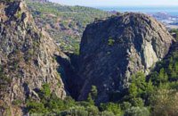 Ierapetra, Lassithi at 27.6km (S) A monument of natural beauty that attract a lot of local and foreign visitors. The gorge of Sarakina (GR: Σαρακίνα) is one of the most beautiful in Crete. Its steep, vertical walls in some parts reach a height up to 250 m. Its widest opening is no more than 15 metres while in some places it’s so narrow that its sides seem to join each other. Its rich flora and fauna, the dittany, the wild birds that nest there, the running water make the route through the gorge a worthwhile experience. 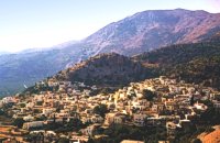 South east Iraklion at 27.7km (S) Historical place with outstanding natural beauty, unspoiled villages and great beaches. The town of Ano Viannos is built amphitheatrically on the southern slopes of Dikti mountain at 560 m. above sea in a distance of 65km from Iraklion and 40km from Ierapetra. It preserves the traditional character with the narrow paved streets, the stone built houses - especially the "Plaka' quarter - the old kefeneios with tables under the plane trees and old churches such as Agios Georgios and Agia Pelagia with wall paintings dating back to the 14th century. There are a few accommodation facilities, banks, medical center, taverns, gas stations, shops etc. Ano Viannos is the seat of the municipality of Viannos.
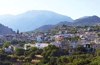
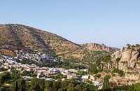 Ierapetra, Lassithi at 28.6km (SE) One of the most beautiful parts of the hinterland of Ierapetra is occupied by the picturesque village of Kalamafka. It is situated on the edge of the Lassithi mountains, an area known for its impressive diversity in landscape. Kalamafka sits at an altitude of 480 meters, 15 kilometers from the town of Ierapetra and 25 kilometers from Agios Nikolaos. Kalamafka is a picturesque, large, and prosperous village surrounded by unique natural beauty. The springs at Kefalovryso, with its plane trees and lush vegetation, as well as its old historical churches, gorges, and springs, attract visitors due to the oasis-like coolness it offers in this otherwise dry and hot region. The village's wealth lies in its water sources and the vitality of its residents, who resist urbanization. Another reason for Kalamafka's enduring population is its advantageous location, as it is centrally positioned between the north and south coasts of the island, drawing daily visitors from Ierapetra and Agios Nikolaos. History: The village derives its name from "Kali Afkla," a wooden channel that was once used to transfer water from one riverbank to another at the springs of Kefalovryso. Another explanation for the name is that the rock formation on Kastelos Hill resembles a Greek Orthodox priest's hat (kalymafki). Kalamafka, known as ancient Larisa, has been inhabited since the Minoan era. In the Psathi area, along the road to Ierapetra, archaeological findings such as human skulls, clay pots, spearheads, and various grave goods from the sub-Minoan era have been discovered. The geographer Strabo mentions Kalamafka, ancient Larisa, as follows: "And in Crete there is the city of Larisa, which now is united with Ierapytna, and from which the plain below, called Larision, takes its name." The god protector of ancient Larisa was Asclepius, and this is why the Medical Association of Lassithi has adopted the figure of a statuette discovered on the Kastelos peak, which overlooks the village and served as a peak sanctuary according to Mr. Michalis Pytikakis. Larisa was conquered around the 3rd century B.C. by Ierapytna, and its residents were relocated as per the terms of the treaty. Evidence from subsequent historical periods suggests that the Kalamafka area has been continuously inhabited due to the presence of the water sources of Kefalovryso. Place names like Kastelos, Mesokastela, and Larisakia attest to its historical significance. Kastelos Hill, serving as the seat of a feudal lord during the Venetian rule, had 435 residents in 1583. It boasted several notable Byzantine and post-Byzantine churches, along with numerous chapels. During the Turkish rule, it was a breeding ground for prominent chieftains like Nikolaos Foniadakis and Ioannis Baritakis. The village's history is marked by struggles and sacrifices that cannot be easily summarized. Today, Kalamafka is a vibrant village with a growing population. It has a two-seat school, a nursery school, a cultural association, numerous coffee houses, and seven taverns. The natural landscape, often referred to as "Chinese" due to its small rock pillars with bonsais, stone formations, and Kastelos Hill with its 224 steps, is considered a monument of natural history. Kalamafka offers visitors a wealth of attractions, including caves, rock paintings, the Havgas gorge, an ancient olive press, and the churches of Saint John and Saint Anthony. The taverns, shaded by plane trees and surrounded by running water, serve traditional and delicious local dishes, including the traditional "klostenios" halva and skyfomakarounes (local pasta). The sounds of the lyra, violin, and lute add to the ambiance, pleasing both locals and foreigners. There are indeed many compelling reasons to visit Kalamafka. By Toby Robert Image Library
 Ierapetra, Lassithi at 29.2km (S) Deep inside the valley of the river Sarantapihos is built the village Mythoi. It is 22 km away from Ierapetra, it is a small village, in a verdurous landscape,with a beautiful square under the shade of age-old planes. It is said that the village took its name from the plant “Minthi”, or mint, which is abundant there.However, it may have been named thus because of its many legends, traditions, and myths (mythoi), the most prevalent one being the Sarantapihos’ one. A mythical giant, forty ells tall, like another Talos or Akritas Digenis, he protected the residents from raids. There are the place names “Tou Sarantapihoui Patounia” (Sarantapihos’ footprint) and “Tou Sarantapihou to Mnima”(Sarantapihos’ grave). There is evidence of ancient habitation at the site “Leniko” where traces of walls can be seen. Also, in an excavation, the head of a woman of the Roman period has been found. At the sites Kastelou Haraki and Orfanou to Spiliari claypots, oil lamps, e.t.c. have been found. The site called Sarakina above Mythoi was a fortress, a hideout of Saracen pirates. The village’s modern history is rich in contributions to the struggles against the conquerors. It nurtured the chieftains Emmanouil Xenikakis, Ioannis Hatzakis, Emmanouil Christakis andothers. During the German Occupation, residents of Mythoi took part in the guerilla corpses of the United Resistance of Captain Bantouvas. In the battle of Symi, one of the most heroic figures was lost, Apostolos Vagionakis, who stood up to the enemy’s bullets for the ideals of our unsubdued Crete. They paid the price of their participation to the struggles during the German Occupation,as 4 persons were executed, including the old and bedridden Nikolaos Ioannou Christakis. The community of Mythoi is today a Local Department of the Municipality of Ierapetra, in 1900 it had 360 Christian residents, in 1951 it had 423 and in 2001it had 287. In the north of Mythoi, around 6 km away, there is the settlementKarydi with the famous Monastery of Panagia (Our Lady) Karydiani and now abandoned summer residences. The mountainous settlement “Minos”, which is situated in a verdurous small plateau below the Afentis peak of the Lasithi mountains, also belongs to the Community of Mythoi.The village Mythoi is a lively village with a rich social and cultural life. It has a cultural association, a football team and field, and a modern olive press. The village’s square with its old plane trees, the mulberry trees, the old fountain,the traditional coffee-houses with the raki and the local dishes, is a place of reference for the residents of Mythoi. The sights, the wild natural landscapes in the north of the village, the famous gorge of Sarakina, a monument of natural beauty, attract a lot of local and foreign visitors. The gorge of Sarakina is one of the most beautiful in Crete. Its steep, vertical sides cause awe, and reach a height of up to 250 m. Its widest opening is no more than 15 m while in some places it’s so narrow that its sides seem joined. Its rich flora and fauna, dittany,the wild birds that nest there and the route inside the gorge are breath-taking. Its promotion is a foremost goal of the Local Department and the Municipality of Ierapetra, of the residents of the village, who head to the future with optimism and anticipation for the development of their place. Source:The Municipality of Ierapetra. 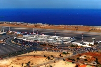 Iraklion ( Nea Alikarnassos) at 29.3km (W) Heraklion International Airport, "Nikos Kazantzakis" (Greek: Κρατικός Αερολιμένας Ηρακλείου, "Νίκος Καζαντζάκης") or Nikos Kazantzakis International Airport (IATA: HER, ICAO: LGIR) is the primary airport on the island of Crete, Greece. It is located about 5km from the main city of Heraklion. Heraklion International Airport is is one of the biggest in Greece and receives approximately 15% of the total tourist traffic of Greece. There are many airlines currently operating flights from Athens and Thessaloniki to Iraklion (Olympic Airways, Aegean Airlines and others), while during the high season there are flights from/to Rhodes, Mykonos, Santorini and other Greek islands. There are also international airlines that connects Iraklion to other European cities. During the summer season there are numerous chartered flights to Iraklion from all over Europe (mainly Germany, the United Kingdom, Russia, and Holland). During the summer months there is a huge increase in air traffic that peaks in August (approximately 130 flights per day). Major car-rental companies have desks at the airport. Taxi and public bus are available for transfer from/to Iraklion. 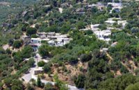 Ierapetra, Lassithi at 29.7km (S) A small village built at an altitude of 540 m in the south parts of the mountain Dikti at the borders of the province of Ierapetra-Viannos. The imposing mountains above the village, the south horizon among the olive-covered hills and in the lower villages, the cool climate create in you a sensation of bodily and spiritual well-being at this balcony of the Cretan nature. Five settlements, two of them uninhabited today, constituted the Community of Riza, now a Local Department of the Municipality of Ierapetra. 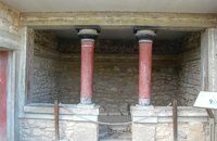 Knossos Palace at 29.8km (S) This house belongs to the New Palace Period (1700-1450 B.C.) and was functionally related to the Palace. In its restored part with two columns, there was a bench on which some object of worship had probably been set up. There was a paved hall in front with a double pier - and - door partition.
Image Library
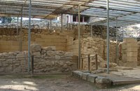 Knossos Palace at 29.8km (S) The south-east house belongs to the New Palace period (1700-1450 B.C.). It was well built and decorated with wall-paintings of lillies. It had a pier-and-door partition, a pillar room and storage rooms. A little behind it are other houses of the Old Palace period (1900-1700 B.C.) such as the house of the "Sacrificed Oxen", named after the remains of a sacrifice found there (horns of a bull and a tripod table of offerings) and the "House of the Fallen Blocks", after the blocks that had fallen from the facade of the palace due to an earthquake. Next to "South-East House" there are houses of the Old Palace period (1900-1700 B.C.), such as that of the "Monolithic Pillars" in front of the steps. Under the small roof is a Minoan, possibly smelting kiln. 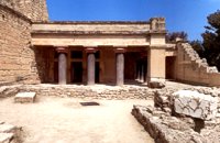 Knossos Palace at 29.8km (S) The "Hall of the Double Axes" was so named by Evans due to the double axe signs engraved on the walls of the light-well at its rear. He also thought that it was the place of residence of the King of Knossos. The central area has openings on three sides and is therefore called a "polythyron" (system with multiple doorways). It has a slab floor and its walls were embellished with gypsum slabs and frescoes. The area between the "polythyron" and the light-well was used as a reception hall. Traces of a wooden construction were found here. Evans reconstructed a wooden throne at this spot. Pictures: 1, 2 According to the archaeological finds, the arrangement of the apartments on the upper floor was similar to those on the ground floor. Image Library
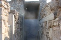 Knossos Palace at 29.8km (S) Here is the so-called "School Room", an area where, according to Evans, scribes were taught to write on clay tablets. He supposed that they kneaded the clay in the built mortar next to the bench. It is more likely, however that it was a workshop for ceramics or wall-painting. Behind the "School Room" is the "Lapidary's Workshop", where blocks of crude or semi-worked lapis lacedaemoniae (spartan basalt) and stone tools were brought to light. According to Evans, the main workshop lay on the upper floor from which vases and large stone amphora had fallen to the ground floor. 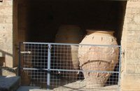 Knossos Palace at 29.8km (S) Here the excavators found a number of very large storage jars (Pithoi) and Evans named the place the "Magazines of the Giant Pithoi". These magazines are one of the older parts of the palace. The pithoi stand out for their size, the number of handles and the richness of their relief decoration with ropes and discs. To the right of the magazines a staircase which has been reconstructed by Evans descends to the east entrance of the Palace. The entrance is a robust construction that gives the impression of a "bastion". From this point it would have been easy to reach an important building of the palatial period, the so-called "Royal Villa" which lies outside the main archaeological site. Image Library
|
||
|
| ||


)
)
)
;)
;)
';top.fotoWin('/dbsf/pages_pics/15/1512321/giant_pithoi01.jpg');)
C
O
N
T
E
N
T
S
O
N
T
E
N
T
S