interkriti®
YOUR GATEWAY TO CRETE
HOME
CRETE FACTS
NAVIGATE
EXPLORE

Agia Galini
Triopetra
Kissamos
Chryssi Isl.
Agia Marina
Balos
Gavdos isl.
Georgioupolis
SAMARIA
IDA Mtn
Palaiochora
Agia Roumeli
Sfakaki
Bali
Kalamaki
Matala
Lassithi
Plateau Lendas
Tsoutsouros
Vianos
Myrtos
Sfakia
Plakias
Ierapetra
Makrygialos
ZAKROS
Vai
Sitia
Agios Nikolaos
Elounda
MALIA
Hersonissos
Gouves
Chania
Rethymnon
Heraklion
GORTYN
FESTOS
KNOSSOS
|
|
Crete
: Regional Interest
List Grid Map
Found
93
- Showing :
61 - 80
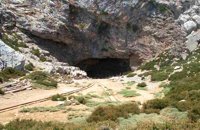 Psiloritis Mountain at 42.3km (E) At 1538m above sea level, 20 km. south of the traditional town of Anogia , on the plateau of Nida, of Mountain Psiloritis, lies this sacred cave, where according to mythology, Rhea, Zeus' mother, hid the new born Zeus in this cave in order to protect him from his father Kronos (Saturn), who was in the habit of swallowing his children because he feared they might deprive him of his power. Hidden in that cave Zeus grew up being fed with the milk of the goat Amalthia, while the 'Kourites" covered the child's crying through banging their copper shields. Image Library
 Omalos, Hania at 42.5km (W) Xylóskalo (Ksyloskalo GR: Ξυλόσκαλο) is the point where the Samarian gorge starts. It is located on the Lefka Ori (White Mountains) in the plateau of Omalos, 43 km from the city of Hania at 1250m above sea level. It is also the entrance to the gorge. There are two tourist lodges where visitors can rest and have food or coffee and take panoramic pictures of the gorge and the White Mountains. There is also the information center of the National Park and a parking area. Xyloskalo means the "wooden stair" and refers to a wooden staircase built by the locals in order to facilitate the entrance to the gorge as at this point the cliffs are very steep. Today this part of the path is made of stones and it has a wooden handrail. About 1km before Xyloskalo a dirt road leads, after 5 km, to the Kallergis mountain lodge at 1680m a.s.l. 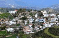 Messara, Iraklion South at 42.6km (SE) Kamilari is a quiet, traditional village, with a panoramic view to the endless olive groves of the Messara valley on the one side, and to the Libyan sea on the other side. It has been inhabited since the Minoan period. One of the seven wise men of the ancient world, Epimenidis, a great wise man and a soothsayer, lived in a small community outside Kamilari, called Metohi.
 Messara, Iraklion South at 42.7km (SE) The village of Pitsidia is located 65 km southwest of Iraklion at an altitude of 80 m a.s.l, just before the magnificent bay of Messara. The village with aproximately 700 inhabitants is the oldest village of the area and is refered (by S. Spanakis) that it was the place where the soldiers of Nikiforos Fokas, commander of the Byzantine army, settled. The army, famous for its bravery, came from Pisidia of the south Asia Minor, and this is probably the origin of the name Pitsidia.
Image Library
 Voroi, Messara, Iraklion at 43km (E) The exhibited objects in the Museum come from all over Crete. These objects show that the folk culture of Crete is characterized by an amalgam of influences in which Minoan (2000-1000 BC), Archaic (1000-500 BC) and Byzantine models prevail, especially in agriculture, stock breeding, pottery and basketry.
 Messara, Iraklion South at 43.1km (E) Vori is a beautiful, traditional village of the county of Pirgiotissas in the Messara Valley. It is located 60 km south of Iraklion and in the western part of the Messara Valley. The village stretches in a slope, by the side of a small river. The archaeological site of Phaistos is 2 km to the south and the coast of Messara 4 km to the west.
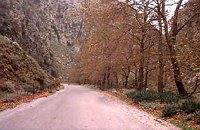 Kydonia,Chania at 43.2km (NW) Within a few distance from the village of Perivolia, starts the gorgeous canyon of Therisso (Theriano faragi or Eleftherios Venizelos Gorge), which leads to the village of Therisso at 580m a.s.l. Six kilometers long, the gorge stretches like a snake, with high, almost vertical walls, and rich flora and fauna.It was a difficult to trespass gate, for the invaders, and that is the reason why Therisso was the center of the Cretan rebels during the 19th Century. The authorities has recently renamed the gorge, giving to it the name of the great Cretan statesman, Eleftherios Venizelos, who's name is strongly related with the area. 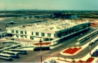 Akrotiri, Chania at 43.7km (NW) Chania International Airport, "Ioannis Daskalogiannis" (IATA: CHQ, ICAO: LGSA) is an international airport located 14km east from Hania, near Souda on the Akrotiri penisula. It is named after Ioannis Daskalogiannis, a Cretan revolutionary against Ottoman rule in the 18th century and is a joint civil - military airport (Souda Air Base). Access:By public bus and Taxi (~16 euros) Airport facilities: Police Station, Parking, Snack bar, ATM, Dutyfree, gift - souvenir shops, local nutrition products. Telephones:Information desk +30 28210 83800 - 83805 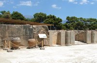 Palace and Archaeological Site at 43.8km (E) The archaeological site, the palace, the findings - The Festos Disc. According to mythology, Phaistos (or Festos) was the seat of king Radamanthis, brother of king Minos. It was also the city that gave birth to the great wise man and soothsayer Epimenidis, one of the seven wise men of the ancient world.Excavations by archaeologists have unearthed ruins of the Neolithic times (3.000 B.C.).
Image Library
 Hania at 44.8km (NW) A guide to the area of Akrotiri. Tourist facilities, regional information and image gallery. Akrotiri with its scenic landscape provides a relaxing, refined country break away from the pressures of urban life. Its numerous monasteries, from the oldest in Crete, played a significant role in the history of the area. Gorges of outstanding beauty offer a unique hiking experience, breathtaking views and the joy of exploration...
Image Library
 Messara, Iraklion South at 44.8km (SE) Its 1000 years history comes to life for the visitor, who has the chance to admire its monuments, and old houses, perfectly preserved through the centuries. In the village square , you can sit and enjoy your coffee in the traditional coffee shop, while children can play in the playground next to the school. You can also visit the church of Agios Ioannis in the same square. There are quite few rooms for rent in the village and tavernas serving traditional Cretan dishes.
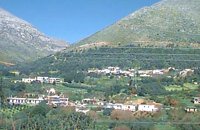 Mylopotamos, Rethymno at 45km (NE) Apladianá (GR: Απλαδιανά) is a small village built at the foot of the two Kouloukona heights. The settlement stretches out along the old national road, where it developed after the opening of the new national road. It comprises cafes, tavernas, and accommodation facilities included in the Countryside Tourism programs. It is worth your while, however, to visit the old village, climbing there on foot or by car. Picturesque, narrow streets, wonderful old houses with interesting architectural elements, old cisterns and churches will reward your efforts. The old village built on a height of 260 m above sea-level has 175 inhabitants and the settlement along the old national road, known as "Kampos ton Apladianon", has 78 inhabitants. It is 40 kilometres away from Rethymnon and is located at the foot of the highest peak of the Kouloukona mountain in the Tallaios range. Historical background Already as far back as 1368 we find a mention of the Aplada family, the founders of the present village and in the topographical maps of the Civil Engineering Services of Rethymnon it figures as Pladiana. The settlement is not mentioned in the 16th and 17th cent. documents. In the 1881 census, Apladiana is attributed to the commune of Garazo, with 57 inhabitants and in 1900 it is referred to as the Apladiana Commune which, together with the Cheliana settlement, had 153 inhabitants. 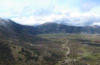 White Mountains, Hania at 45.2km (W) The famous - mainly due to the gorge of Samaria- plateau of Omalos (GR: Ομαλός) is surrounded by the high crowns of the Lefka Ori (White Mountains) at 1,040 to 1,250 meters and is just 38 km from the town of Chania. It extends to the counties of Sfakia, Selino and Kydonia in the prefecture of Hania. Its shape is nearly rectangular with a perimeter of about 25kms and a diameter of approximately 4 kms. It can be reached by car from the north (Neratzoporo) and from the south (Agios Theodoros).
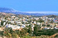
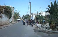
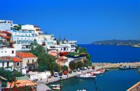 Rethymnon North coast at 45.3km (NE) Bali is a small fishing village, about 40 km west of Iraklion and 37km east of Rethymno easily accessed from the international road. It has a small picturesque harbour and lots of small coves with wonderful clear beaches. Recent years Bali has been developed to a popular tourist resort but it is still preserves its traditional character. Ideal place for family holidays, with small hotels and lovely taverns serving fresh fish and local specialties. 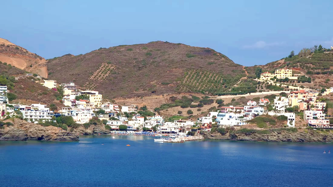 The Venetians called the place "Atali", from its ancient name which was "Astali", while its current name was given by the Ottomans. There is also the Atali Monastery nearby, which retains the medieval name of the place and is dedicated to Saint John. The monastery is built on a small elevated peninsula overlooking the bay and the Cretan sea. Image Library
 Chania at 45.3km (NW) The village of Mournies is a principal village, located 3.8 km south of Hania at 40m a.s.l. It took the name "Mournies" from the numerous mulberry trees, that use to be here even today. At the beginning of the 17th century, Mournies was famous for its beautiful villas, belonging to local noblemen. One of them, located southeast of the village, was the imposing three storey villa of "Koukounara". It had beautiful flowery gardens, fountains, statues ..., a real paradise, where many famous persons were received hospitality, amongst them the glorious Mme Ortans, the empress Eugene of Napoleon the third, queen Olga of Greece, and the king Constantinos in 1913. The villa today, being restored, houses a department of the Geek Navy. Mournies was the birth place of one of the greatest statesman of the new Hellenic Republic, Eleftherios Venizelos. Venizelos' influence on the history of Greece was paramount, from his participation to the talks with the Ottomans that resulted to granting Crete independence in 1897, to the final union of Crete with Greece in 1913. The house of Venizelos located in Mournies is going to be a museum, and many personal items of the politician are going to be on display there. 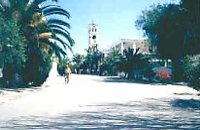 Moires, Messara at 45.4km (E) The monastery of Panagia Kaliviani is located at the 59th km on the road Iraklion-Phaistos. The monastery was built during the second Byzantine period. The small Byzantine chapel was painted with frescoes but most of them are today destroyed. The chapel was deserted until, during the Turkish occupation in 1873, an old small icon of the Annunciation of the Holy Mother was miraculously found there.and the monastery became a place of worship.  Anogia at 45.6km (E) The artistic events, which take place every year in the first week of July at the same place called Fourni and in the Cretan village of Anogia. The poet, songwriter and singer from Anogia, who they call "Loudovikos from Anogia" wants to make the history of the young martyr, who supersedes his fear in love known to the public. And because 1.900 years have passed since the martyrdom of Yakinthos, he decided to honor the Saint of Love and sing together with him of the poetry of love.(www.yakinthia.com)
 Voriza, South - West Iraklion at 45.8km (E) Close historical bonds link this monastery to that of Vrontisiou. The Varsamonerou Monastery lies in the surrounding fields of the village Voriza, 54.5 kms from Heraklion. The monastery is abandoned and, though its cells have been destroyed, its church has some of the most remarkable wall paintings in Crete.
 Gavdos, SW Crete at 45.9km (SW) The only inhabited island of Crete with approx. 40 permanent residents. There are some nice beaches with fine sand, a few rooms and apartments to rent and some taverns. Apart from the harbor Karave, there are three village on the islet, Kastri (the capital), Vatsiana and Ambelos. The landmark of Gavdos is the Light House built in 1880. According to Callimachus, this is the ancient isle of Ogygia where, as Homer claims in "Odyssey", the nymph Calypso lived. Distance from Sfakia 22 nautical miles and from Paleohora 32 n.miles. Ferry connection from Sfakia (Tel. 28250 91292) and Paleohora (Tel. 28230 41214). Gavdos island video (Youtube) Image Library
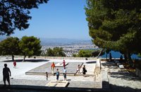 Akrotiri, Chania at 46.3km (NW) At the magical and historical location of Profitis Ilias, in Akrotiri, at the east of Hania lays the tomb of Eleftherios Venizelos, one of the most long-standing prime ministers of Greece and whose political life was focused on doubling the size of Greek territory and on the creation of a contemporary State. Eleftherios Venizelos himself had designated this position to be his resting place before his death. For the visitor, it affords a panoramic view of the rich green plain of Hania, the imposing White Mountains, the Cretan Sea, the town of Hania and the Chalepa quarter which is the location of the house in which the great politician spent most of his life and today is the headquarters of the National Research Foundation 'Eleftherios K. Venizelos'. Image Library
|

|
|
|
| ||

)
C
O
N
T
E
N
T
S
O
N
T
E
N
T
S