interkriti®
YOUR GATEWAY TO CRETE
HOME
CRETE FACTS
NAVIGATE
EXPLORE

Agia Galini
Triopetra
Kissamos
Chryssi Isl.
Agia Marina
Balos
Gavdos isl.
Georgioupolis
SAMARIA
IDA Mtn
Palaiochora
Agia Roumeli
Sfakaki
Bali
Kalamaki
Matala
Lassithi
Plateau Lendas
Tsoutsouros
Vianos
Myrtos
Sfakia
Plakias
Ierapetra
Makrygialos
ZAKROS
Vai
Sitia
Agios Nikolaos
Elounda
MALIA
Hersonissos
Gouves
Chania
Rethymnon
Heraklion
GORTYN
FESTOS
KNOSSOS
|
|
Crete
: Sightseeing
List Grid Map
Found
77
- Showing :
61 - 77
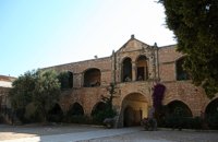 Rethymno at 35.5km (W) The Monastery of Arkádi (GR:Αρκάδι) built during the last Venetian period, it consists of a large set of fortress-like buildings. The main building included the cells, the warehouses where the agricultural products were treated and stored, the stables. In a word, it was a well-equipped little fortress where people could find refuge in times of trouble. There is an impressive church, with two naves dedicated to Saint Constantine and Saint Helen, and to Our Lord. Due to the holocaust it suffered in 1866, Arkadi has become the island's most famous monastery.
Image Library
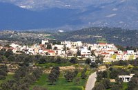 Messara, Iraklion South at 36.6km (SW) Its 1000 years history comes to life for the visitor, who has the chance to admire its monuments, and old houses, perfectly preserved through the centuries. In the village square , you can sit and enjoy your coffee in the traditional coffee shop, while children can play in the playground next to the school. You can also visit the church of Agios Ioannis in the same square. There are quite few rooms for rent in the village and tavernas serving traditional Cretan dishes.
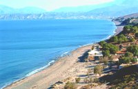 Messara Bay, Iraklion at 39.6km (SW) One of the most beautiful sandy beaches of Crete, extends from a clump of rocks riveted in the shallow waters in the south to the Kalamaki settlement in the North. In Minoan times there used to be the ancient port of Phaistos. The antiquities lie just a few meters away from the sea.
Image Library
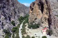
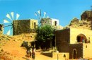 Seli Ampelou, Lassithi Plateau at 40.8km (E) It is the most significant group of windmills preserved on Crete. It occupies the northern entrance to the Lasithi plateau and is the landmark of the whole area. Today 24 windmills are preserved (out of the original 26), 7 of which extend to the south of the road that enters the plateau while the rest are built to the north of it. All the mills belong to the one-sided type of windmill, that grinds in a standard position, always on the same direction of the wind. Windmills of this type are preserved on Crete and on Carpathos but the Cretan ones are generally more carefully built and more elegant. The group of windmills has been declared a work of art since 1986. The mills belong to individuals and some of them have been restored while others still remain half-ruined. Source: The Hellenic Ministry of Culture 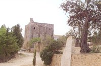 Messara plain, South - East Iraklion at 41.3km (SW) The monastery of Odigitria is a monastery of great importance and historical value and one of the oldest in Crete. It is located at the west edge of the Asterousia mountains at an altitude of 250 m. The monastery was surrounded by walls, part of them still stands. The temple of the monastery is dedicated to the assumption of Holly-Mother and to the Saint Apostles (Peter & Paul). Inside the temple there are valuable frescoes, icons of famous painters and iconostasis. The monastery is connected with the legendary freedom fighter 'Ksopateras' (1788 - 1828) In the area of the monastery at Agioi Eftihianoi was found an ancient (Early Minoan) cemetery. 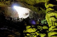 Psychro, Lassithi Plateau at 41.4km (E) The cave of Psychro is one of the most important cult places of Minoan Crete. The excavators and several scholars identify the cave as the famous "Diktaian Cave", where Zeus was born and brought up with the aid of Amaltheia and the Kouretes, and which is connected with myths as this of the seer Epimenides who "slept" here, or the coupling of Zeus with Europa.
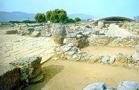
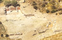 Lentas, South Iraklion at 41.6km (S) The first habitation of the site dates from the Neolithic and Early Minoan period (3rd millenium B.C.). In the late Classical period (beginning of the 4th century B.C.) the Gortynians established the sanctuary of Asklepios at the harbour. During the tremendous earthquake of 46 B.C. the city was destroyed and subsequently rebuilt. In the Early Christian and Byzantine periods, a small settlement developed and the basilica was erected. The most important monuments of the site are: The Temple of Asklepios., the "Treasury"., the Fountain, a large, three-aisled basilica, an Early Minoan settlement (2600-2000 B.C.), the West Stoa, the North Stoa, the Nymphaion and two large, mud-brick cisterns. 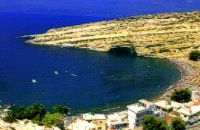 Messara, South - West Iraklion at 41.8km (SW) Matala (GR: Μάταλα) was the ancient port of Phaistos and Gortys and a former fishing community which has developed into a modern holiday center. It is located 4 km south-west of the village of Pitsidia and 75 km from Iraklion. It is built on the coast line of the Messara bay inside a small and picturesque inlet. During the 60's the caves of Matala were hosting a hippie commune.
 Archaeological site in Malia, Iraklion at 42.8km (E) The Palace of Malia, which covered an area of 7,500 sq.m. , was the third- largest of the Minoan Palaces and is considered the most "provincial" from the architectural point of view. The first Palace was built in 1900 BC and destroyed in 1700 BC when a new Palace was built. Following the fate of the other palaces in Crete it was also destroyed in 1450 BC. and the present ruins are mainly those of the new palace.
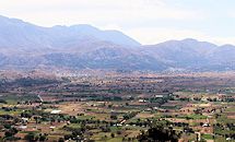 Lassithi, Dikti Mountains at 43.7km (E) The Lassithi Plateau (GR: Οροπέδιο Λασιθίου, Oropedio Lasithiou), is a high endorheic plateau, located in eastern Crete, Greece on the mountain range of Dikti at an average altitude of 840 m, and in a distance of around 55km from Heraklion and 50km from Agios Nikolaos. The plateau is elliptical in shape with an E-W axis of 11km and the N-S of 7km. The plateau of Lassithi is renowned for its exceptional agricultural produce, the thousands (almost 15000) windmills that used to be there in the past, its significant historical role and for the unique cave of Psychro also known as "Diktaion Andron". Image Library
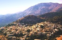 South east Iraklion at 44.5km (SE) Historical place with outstanding natural beauty, unspoiled villages and great beaches. The town of Ano Viannos is built amphitheatrically on the southern slopes of Dikti mountain at 560 m. above sea in a distance of 65km from Iraklion and 40km from Ierapetra. It preserves the traditional character with the narrow paved streets, the stone built houses - especially the "Plaka' quarter - the old kefeneios with tables under the plane trees and old churches such as Agios Georgios and Agia Pelagia with wall paintings dating back to the 14th century. There are a few accommodation facilities, banks, medical center, taverns, gas stations, shops etc. Ano Viannos is the seat of the municipality of Viannos.
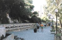 Spili, Rethymno at 45km (W) Spili (GR:Σπήλι) is 30 km away from Rethymnon, along the road that goes from Rethymnon to Armenoi and then Spili. The town has about 800 inhabitants and it lies at a height of 430 m above sea level, at the foothills of Mount Vorizi, which belongs to the Kedros chain. The landmark of the town is the square at Kefalovrissi with the 25 fountains each one in the shape of a lion's head. The square is named after Thanassis Skordalos (1920-1998), a popular lyra player and composer born in Spili. Spili is a modern town, with all the facilities and services required by the locals and by the large number of visitors. Image Library
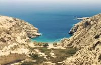 South - coast Iraklion at 46.5km (SW) Martsalo (GR: Μάρτσαλο, Mártsalo) is located on the mass of the Asterousia Mountains between Kefali (Cape Lithino) and Agiofarago. It is an impressive gorge about two kilometers long, which belongs to the hermitages of the Holy Monastery of Odigitria. Inside the gorge there is rich vegetation as well as a small palm forest in the middle of its route. The impressive cliffs are home to a large number of caves (similar to eagles' nests) inhabited by many of the area's ascetics. Gorge Martsalo is particularly steep and rough and ends at the Libyan Sea, where there is a small protected cove with a sandy- pebbly beach. Image Library
 South - coast Iraklion at 46.7km (SW) Agiofaraggo (GR: Αγιοφάραγγο the gorge of Saints) is a small gorge at the southern shores of Heraklion close to the village and the beach of Kaloi Limenes and 6 kilometers south of the Monastery of Odigitria. Image Library
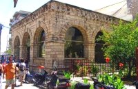
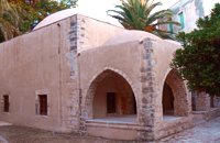 Rethymnon Old Town at 49.6km (W) The Mosque took its name from the Turkish commander of the marine operations to conquer Rethymno, in 1646. During the Venetian Period, the Mosque became a monastery dedicated to St. Barbara. West from the central building, there is the deserted minaret of the mosque. The fountain of the Mosque is attached to the roofed entrance of the Mosque's garden, where believers washed before entering the Mosque and provided the area with fresh spring water. Image Library
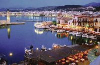 Rethymnon town at 49.9km (W) Rethymnon old port was of great strategic importance during the Venetian period. It was only able to accommodate small ships. From 1300 until today, the Venetian port has undergone numerous constructions. The 1618 wall that surrounds the port from the east is restored today with some recent interventions and additions. The original lighthouse was constructed during the Turkish period and was later replaced by another one. The building on the southeast part of the port was constructed in 1931 and functioned as a customs office. On the same location it is estimated that there was a quarantine house during the Venetian period. The vaulted spaces on the two or three-floor buildings at the port have been transformed to little and picturesque fish taverns, where visitors can enjoy the secrets of the Cretan cuisine.
 Rethymnon Old Town at 50km (W) Loggia has been built during the 16th century and was designed by the famous architect Michel Sanmicheli. Loggia was an eminent building of the city centre and has been a meeting point for the nobles to discuss political and economical issues. The building is very well preserved; it is square and has arches on its three sides (besides its west side). The consoles of its eaves are spectacular. During the Turkish occupation the loggia became a mosque and a minaret was constructed, which was later demolished in 1930. The past 40 decades the building of Loggia hosted the archaeological museum of the city, which has now moved to a building next to Fortezza. Today loggia hosts a market of archaeological art copies.
|
||
|
| ||


C
O
N
T
E
N
T
S
O
N
T
E
N
T
S