interkriti®
YOUR GATEWAY TO CRETE
HOME
CRETE FACTS
NAVIGATE
EXPLORE

Agia Galini
Triopetra
Kissamos
Chryssi Isl.
Agia Marina
Balos
Gavdos isl.
Georgioupolis
SAMARIA
IDA Mtn
Palaiochora
Agia Roumeli
Sfakaki
Bali
Kalamaki
Matala
Lassithi
Plateau Lendas
Tsoutsouros
Vianos
Myrtos
Sfakia
Plakias
Ierapetra
Makrygialos
ZAKROS
Vai
Sitia
Agios Nikolaos
Elounda
MALIA
Hersonissos
Gouves
Chania
Rethymnon
Heraklion
GORTYN
FESTOS
KNOSSOS
|
|
Crete
List Grid Map
Found
93
- Showing :
81 - 93
 Hania at 43.1km (NE) A guide to the area of Akrotiri. Tourist facilities, regional information and image gallery. Akrotiri with its scenic landscape provides a relaxing, refined country break away from the pressures of urban life. Its numerous monasteries, from the oldest in Crete, played a significant role in the history of the area. Gorges of outstanding beauty offer a unique hiking experience, breathtaking views and the joy of exploration...
Image Library
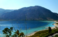 Apokoronas, Hania at 43.3km (E) Crete's only freshwater lake, Lake Kournás (GR: Λίμνη Κουρνά), is relatively large, with a perimeter of 3.5 km. Although almost all touristic leaflets say that it is possible to walk around the lake, that is not true. At least not at the end of the rain season (winter). There is a nature preserve on the Southwest of the lake. But there is a rustic road from the North of the lake to the Hills on the West of the lake too. Image Library
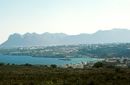
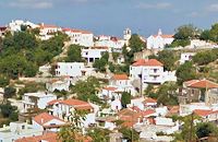
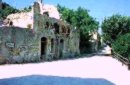
 Apokoronas, Hania at 43.3km (NE) The community of Kefalas (GR:Κεφαλάς) is situated in Apokoronas, Hania, approximately 4 km to the east of Vamos. During the Venetian occupation higher and lower Kefalas were classed as two separate villages, however, today they have become one. It is a large village built in an outstanding position facing the sea with architecture dominated by the influence of the early and late years of the Turkish occupation. This influence is well preserved despite the existence of other architectural styles. The church of Timios Stavros (16th century) is the oldest building of the village while the more recent churches of Panagia, Agios Antonios, and Michael the archangel, works of the reputed Kefalas craftsmen, are examples of folk architecture of the 19th century. A further example of the work of the same craftsmen is the Public School of Kefalas, which in accordance with the decision of the county council of Hania will house the Environmental Educational Centre of the prefecture, a foundation that will play a definitive role in the development of the municipality of Vamos. Other interesting communities are Paleloni and Drapanos in the direction of Kokino Horio. The road from Paleloni leads to Embrosgialo, a relatively easily accessible place, along the steep coastline, which extends to Georgioupoli. 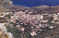 Apokoronas, Hania at 43.9km (NE) Kókino Horio (GR: Κόκκινο Χωρίο), which is located at a higher altitude, has maintained its traditional architectural style even more so than the other villages with its narrow roads, beautiful gates and tiled roofs. A group of cisterns, built in a sloping field, gather the rainwater, an interesting example of local architecture, dealing with the permanent problem of lack of water. Above Kokino Horio one can see the strangely shaped hill Drapanokefala or Calapodha (so named during the venetian occupation). The coastline northwest of the village is an extremely interesting place for a stroll due to the ground formation and the caves, such as the cave of Petsi (or Karavotopos). Another cave called Katalimata, located at the centre of the village, is also an interesting site. At cape Drapano, approximately 10 metres under water, is the impressive Elephant cave, an area 60mx60m full of stalactites and stalagmites of various shapes and colours. Video - The Elephants' Cave 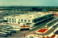 Akrotiri, Chania at 44km (NE) Chania International Airport, "Ioannis Daskalogiannis" (IATA: CHQ, ICAO: LGSA) is an international airport located 14km east from Hania, near Souda on the Akrotiri penisula. It is named after Ioannis Daskalogiannis, a Cretan revolutionary against Ottoman rule in the 18th century and is a joint civil - military airport (Souda Air Base). Access:By public bus and Taxi (~16 euros) Airport facilities: Police Station, Parking, Snack bar, ATM, Dutyfree, gift - souvenir shops, local nutrition products. Telephones:Information desk +30 28210 83800 - 83805 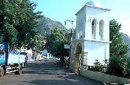 Rethymnon at 44.6km (E) It is built at 500m a.s.l. and 37km away from the city of Rethymno, with 400 inhabitants most of them farmers and stock breeders. It took its name due to its position, "MYRIOKEFALA" means myriads of heads (here :Hills). It is the birth place of George Maravelakis, a great fighter of the 1866 revolution against the turks. The monastery of Miriokefala, an interesting sight, devoted to the Holly Mother, was established by Ai Kir Giannis (a Cretan Saint) in the 11th century. There are many icons of Byzantine art, among them this of Holly Mother.
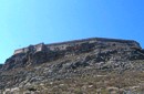 Gramvoussa Cape, Kisssamos at 45.2km (NW) Due to its strategic location, Gramvoussa was fortified by the Venetians, who built a well-fortified castle on the top of a steepy rock at an altitude of 137 m. Construction on the castle of Gramvoussa started in 1579 and ended in 1582.
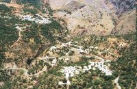 Rethymno south at 45.8km (E) Two small villages, Epano & Kato (Upper & Lower) Rodakino halfway from Plakias to Frangokastelo, overlooking the bay of Korakas. Rodakino is 42 kms from Rethimnon, 27 kms from Hora Sfakion and 13 kms from Fragokastello. Rodakino is surrounded by small beaches some of them accessible only by foot, were visitors can isolate themselves from any trace of civilization. There are some small hotels and rooms to rent available and a couple of tavernas. The road to Rodakino is asphalt paved and there is a bus service to Rodakino from Rethimnon twice a day. In the village the visitor can find a taxi station, and a gasoline station. A doctor is available for medical emergencies on the village of Plakias approximately 15 kms from Rodakino. Rodakino played its own part during the eons, in the fighting of the Cretans against all the invaders. The village was totally destroyed during the Venetian occupation, with only one resident escaping to Peloponnese in Greece . Years after the destruction he returned to the site of the village, and he rebuilt it. In Kourkoylo one of the quarters of the village the first rising of the flag of the revolution against the Turks was raised on May 24th 1821. During the second World War the kidnapped German general Craipe was sent away from the bay of Korakas to the Middle East. Image Library
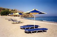 Rodakino, South Rethymno at 46.3km (E) At the end of the canyon that traverses the area of Rodakino lies the beach of Korakas at the bay of the same name. It is a nice, wide and 400m long beach, with clear waters and small grayish sand and pebbles. There are a few accommodation options in family run apartment complexes and a few taverns on the beach front. Umbrellas and sun beds are also available at the eastern part. The headland to the east separate Korakas Beach from another lovely beach named "Klimata". At the east side of that headland there is a small fishing harbour and along its coast there are sharp rocks in the shape of a crow's beak (Kórakas GR: Κόρακας, means crow) thus giving the name to the bay. Image Library
 Rethymnon North at 47.7km (E) A beautiful small town in the county of Rethymno with great views, natural water springs and lush vegetation. It's located at 260m a.s.l. between the rivers "Mousselas" and "Petres", 22km from the national road and 5km from Episkopi. Argiroupolis is the site of the ancient city of Lapa.
 by Richard Ellis at 47.7km (E) 28th August - Because we had researched this bit in May, it wasn't so daunting to leave the tarmac-bound E4 and to launch off uphill to make the old crossing (not yet on any map) between here and Askyfou. The first gully climb up to 3,300 ft was quite straight forward as we had done it before. Distance: 22.4 km Time: 8 hrs. 35mins. Mov av 3.7 km/hr Height overnight: 714m.  Rethymnon North at 48.4km (E) Episkopi is a small town of the prefecture and county of Rethymno. It is located at the old national road of Rethymno - Hania, 17 km away from the city of Rethymno. The town is built at 120 m a.s.l. overlooking the northern coast of Crete, and the green and fertile valley of Mousselas river.
 Rethymnon at 49.7km (E) Zouridi is a village of the county of Rethymno, located 19,5 km away from the city, built at 260m a.s.l. with 90 inhabitants. Here excavations unearthed findings from the post palace period, and the Roman period as well as many venetian houses. Nowadays the village is characterized as a preservable settlement, and buildings such as the old high school are going to be restored.
|
||
|
| ||


;)
;)
;)
;)
;)
C
O
N
T
E
N
T
S
O
N
T
E
N
T
S