interkriti®
YOUR GATEWAY TO CRETE
HOME
CRETE FACTS
NAVIGATE
EXPLORE

Agia Galini
Triopetra
Kissamos
Chryssi Isl.
Agia Marina
Balos
Gavdos isl.
Georgioupolis
SAMARIA
IDA Mtn
Palaiochora
Agia Roumeli
Sfakaki
Bali
Kalamaki
Matala
Lassithi
Plateau Lendas
Tsoutsouros
Vianos
Myrtos
Sfakia
Plakias
Ierapetra
Makrygialos
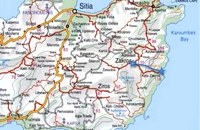
ZAKROS
Vai
Sitia
Agios Nikolaos
Elounda
MALIA
Hersonissos
Gouves
Chania
Rethymnon
Heraklion
GORTYN
FESTOS
KNOSSOS
|
|
Crete
List Grid Map
Found
116
- Showing :
101 - 116
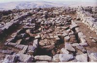
 Hersonissos, Iraklion, Crete at 45.9km (NW) The Cretan Open-air Museum 'Lychnostatis' aims to promote the understanding and awareness of the Cretan folk cultural heritage. Its scope lies on the Cretan Folk Tradition and Ethnology, the Cretan Nature and Environment and the Cretan Folk Culture. Located in Hersonissos, one of the principal tourist areas in Crete, the museum is, apart from a valuable tourist asset, an exemplary self - motivated conduct on tradition, culture and environment of the island. 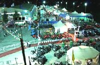 Arkalohori at 46.5km (W) A modern exhibition and congressional centre offering 8000 square meters of total space, 1500 of them being indoors. Among many events that take place in this centre is the Pancretan Agricultural and Commercial Exhibition of Arkalochori held every two years at the end of August. The exhibition attracts a large number of enterprises, manufacturers and services participating and is being visited by over 30,000 visitors from all over Crete. It is considered to contribute essentially in the rapid commercial and cultural development of the wider area. Photo The Municipal Open Theatre Located in the area of the exhibition centre the theatre is of semicircular shape with a capacity of approximately 1000 seats. The facility offers also a canteen, toilets, dressing-rooms for the actors, store room of scene and backstage.The cultural events that the Municipality organises every summer, attract visitors not only from the wider area but also from Iraklion city. Photo Photo 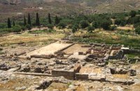 Sitia, East Crete at 46.8km (E) Like the other Cretan palaces, the palace of Zakros, was first built in about 1900 B.C. The present ruins seen by the visitor belong to the second building phase, in about 1600 BC. The total area of the palace, including ancillary buildings, is approximately 10,000 sq.m. It was not only the permanent residence of the royal family, but also the administrative, as well as commercial and religious centre of the surrounding area. The long term excavations have yielded over 10,000 objects, many of them considered unique, which are now on display in the Iraklion and Sitia museums. Image Library
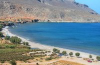 Kato Zakros at 47km (E) Small coastal village at the eastern edge of Crete. Here in 1961 a great Greek archaeoligist, N.Platon, unearthed the fourth largest Minoan Palace. Nowadays in Kato Zakros (GR: Κάτω Ζάκρος) live a few people, occuping with farming, and fishing. There are a few taverns and cafe bars available for the visitors as well as a few rooms for rent. The scenery is great and the sandy beach with crystal clear water is one of the nicest in eastern Crete. Apart from a visit to the Minoan site the visitors can take a walk through the imposing gorge of the dead or follow the path along the coast to the cave of Pelekita
Image Library
 Richard Ellis walk: Day 1 at 47km (E) The E4 path out of Zakros starts a short way south of Hotel Zakros on the main road and is signed up to the right along with signs for old water mills and the like. You have to poke about a bit in the upper levels of Zakros to be certain of being on the right path but upwards and westwards is the key. Distance:6.7 km Time: 1.5 hrs. Mov av 4.9 km/hr Height overnight: 225 m. 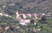 Pediada, Iraklion at 47.1km (NW) To the east of Smari, at 400 m above sea level, with 99 inhabitants, Lagou (GR: Λαγού) is first mentioned in the Turkish census of 1671 with 4 haratsia (head tax). The journey to the village is charming getting you through areas of impressive wild landscape, and the typical old stone houses of Lagou, through the combined efforts of the members of the cultural centre, are being restored to their original traditional form so as to get the well deserved honour of being considered a protected traditional settlement. Image Library
 Pediada, Iraklion at 47.3km (NW) Smari has a very long history and was inhabited, according to reliable sources, from the proto-Minoan period onwards. The archeological relics in the Akropolis of the hill called Profitis Elias, excavated under the direction of the Archeologist D. Hatzi Vallianou, indicate a continuous human presence from the Middle-Minoan period to about 630 B.C. 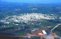 Central Iraklion at 47.6km (W) The town of Arkalochori (GR: Αρκαλοχώρι) with a population of 2.881 is located 33km away from Heraklion, on the provincial road linking Heraklion and Viannos, at 395m above sea level. Its inhabitants are mostly involved in agriculture, but in commerce and arts as well. Arkalochori is one of the most developing towns in the prefecture of Iraklion both in economic and cultural sectors and is the administrative center of the area. Events such as the Pancretan Agricultural and Commercial Exhibition, that takes place here are of great significance and interest for the whole island. The town offers a full range of modern facilities to its residents and visitors.
Image Library
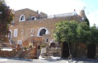
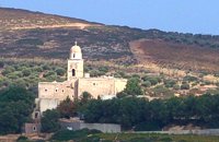 Sitia at 47.8km (NE) It is an historical monastery of the 15th century, which collapsed in the earthquake of 1612 and was rebuilt with the financial aid of the Venetians. During the Ottoman conquest of Crete, the monastery was destroyed and devastated by the Turks. In 1704 the monastery was declared stauropegion. During the Ottoman occupation there was a school in the monastery, while, after 1870, it was founded there a school of mutual teaching. The Monastery is a stauropegion fortress. The main building of 800 m2 has three floors, which are divided into cells, guest - houses, kitchens, the abbot' s residence and warehouses. The katholicon is a two-aisled church; the northern aisle is dedicated to the Virgin, and the southern posterior aisle, to St John the Theologian. The monastery' s characteristic bell tower bears relief crowns and crosses with inscriptions and the date 1558. In the Monastery, there is also an interesting Museum.
Image Library
The Crete Golf Club Hersonissos, Pediada at 47.9km (NW) 18 holes in a desert course design. Each hole individually sculptured, seamlessly blending into the existing landscape...The new Bob Hunt masterpiece (head of design at the PGA Golf Management Ltd of Great Britain), is best described as a desert golf course hewn out of rolling landscape little more than half an hour from the international airport of Heraklion. It boasts a series of memorable holes that will test every aspect of a golfer's repertoire and offers stunning views over mountainous landscape that has hardly changed since the Minoan era back in 2600 to 1100 BC. 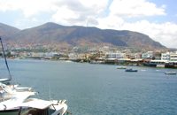 Pediada, North - East Iraklion at 48km (NW) The most popular tourist resort in Crete. Nice beaches, sights and facilities for all tastes and ages. Together with Malia, are the party places for young visitors. Close to Hersonissos there are three small traditional village, those of Piskopiano, Koutouloufari and Old Hersonissos.
 Pediada, Iraklion at 48.1km (NW) Apostoloi (GR: Αποστόλοι) is a village in the area of Kasteli, 360 m above sea level. It has about 490 inhabitants, and is located on the 32 km of the road leading to Kasteli in the NW part of Apostolianos Kampos, among vineyards and olive groves. Until recently tannery was a main activity among the villagers. The earliest reference to the name is to be found in a contract drawn in 1279, where Sancti Apostoli et Sophoro were lands belonging to the Venetian lord Leonardus Gradonicus, who gave them and leased them to Petro Quinino. There is another mention of the name in a document dated to 1378. It is also quoted by Fr. Barozzi in 1577 as forming part of the Pediada district. The name of the village finds its origins in the name of an old church dedicated to the Saint Apostles. The present church was built on the same site in the 19th century, in 1876. The church of Agios Giorgos is Byzantine and has wall paintings. According to village tradition, on the night of Easter in 1841, the Turks caught the Cretan leader of the revolution for the Eastern part of the island, Giorgos Vassilakis, or Vassilakogiorgi and hanged him from a fig tree.The village kapheneions serve particularly good raki and on June 29th there is a great feast in the honour of the Saint Apostles, Peter and Paul. 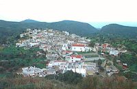 Gouves, Iraklion at 48.5km (NW) At a height of 320 m above sea-level, Kalo Chorio (GR: Καλό Χωριό) λιεσ 25.7 kms. from Heraklion, to the right at the cross-roads at km 16.7 on the National Road to Agios Nikolaos and on the road to Gouves- Koxare- Kalo Chorio. The present name does not figure in old Venetian documents, though there is a reference in the 1367 Duke’s archives of Chandax to a Kalo Horio, without however naming the district. The villagers maintain that the village was called Stravorina in the old days, and indeed there is a reference by Barozzi in 1577 to a village Stravorina in the district of Pediados. In the 1583 Register, the village Stravorina is mentioned as having 76 inhabitants and in the Turkish census of 1671 Istavrine is quoted as having 21 "charatsa" (A Turkish word referring to a tax paid by the head of each family; hence 21 families). However, Chourmouzis Vizantios in 1842 mentions Kalo Chorio, the present name was therefore given in the decade 1830-1840. The village counted 298 inhabitants in 1981 which is also the current population. The Maza hill-top, south-east of the village, is 457 metres high. According to archaeologists (among them the famous N. Platon) and on the basis of recent finds, the name Maza comes from pre-Hellenic years and means Mother Earth. The pile of stones on the hill was, according to N.Platon, a town from the 10th to the 8th c. BC. The highest part was undoubtedly used as a shrine in Middle-Minoan years, and clay figurines and offerings were found there. The shrine lay quite close to the town. The shrine stopped being used in Proto-Geometric years. Northeast of the village, by the country road that leads from Kasteli to Hersonissos, traces of ancient installations have also been found along with remnants of water tanks by a source that is still in use today. These water tanks, probably belonged to Hersonissos aqueduct, parts of which are still visible today in Aposelemi valley. There is as well an interesting gorge close to Kalo Chorio, in the valley of Aposselemis river, worth seeing for nature lovers. 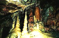 Zakros, Sitia, East Crete at 48.8km (E) The cave, with impressive stalagmites and stalactites, is located near the sea (~200m), at Pelekitá (GR: Πελεκητά), a place 3km away from the Palace of Zakros (~1 hour walk)and above the small bay of Karoumbi. In this cave were discovered signs of neolithic habitation. Its entrance is at 105m above sea, it is 310m long and its area is approximately 4.500m2. A little further there was found also the quarry from where the ancients took the stones to built their Palace (hence the name "Pelekita"). The cave is also known as "Sikias Spilios" (the fig tree's cave) due to the fig tree that is located at its entrance. The view to the sea from there is magnificent.
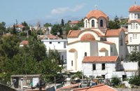
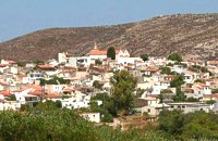 Pediada, Iraklion at 49km (NW) The village of Smári (GR: Σμάρι) is a traditional Cretan village, only 10 km away from Kasteli and has 375 inhabitants. In it you will find beautiful old stone houses that have been restored, picturesque little alleys, ruins of older buildings and pottery workshops where you can purchase copies of Byzantine and Minoan ceramics. There are also some interesting churches with wonderful frescoes like the one dedicated to Sotir Christos, the Koimisi tis Panagias and Agios Giorgos. The earliest reference to the village of Smari dates back to 1375. There is a lively Cretan feast on July 20th in honour of Profitis Ilias, with much rejoicing, singing and dancing. 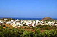 Sitia, East Lassithi at 49.8km (NE) Palekastro (Palaíkastro GR: Παλαίκαστρο) is a lively, unpretentious town, at the east coast of Crete 20 km. away from Sitia and the seat of the Municipality of Itanos. It was named after an old castle. Its sources main income is agriculture and tourism. Although the town is growing, it manages and retain its character and charm. The town's square is the center of activities and is lined with cafes and taverns. Many a pleasant hour can be passed here, watching the world go by. During the summer months, weddings are often held in the village, with the huge wedding feast taking place in the square, to which everyone is invited. A chance to try your hand at Cretan dancing! |
||
|
| ||


)
)
)
';top.fotoWin('/dbsf/pages_pics/15/1522205/aposselemi_gorge01.jpg','');)
C
O
N
T
E
N
T
S
O
N
T
E
N
T
S