interkriti®
YOUR GATEWAY TO CRETE
HOME
CRETE FACTS
NAVIGATE
EXPLORE

Agia Galini
Triopetra
Kissamos
Chryssi Isl.
Agia Marina
Balos
Gavdos isl.
Georgioupolis
SAMARIA
IDA Mtn
Palaiochora
Agia Roumeli
Sfakaki
Bali
Kalamaki
Matala
Lassithi
Plateau Lendas
Tsoutsouros
Vianos
Myrtos
Sfakia
Plakias
Ierapetra
Makrygialos
ZAKROS
Vai
Sitia
Agios Nikolaos
Elounda
MALIA
Hersonissos
Gouves
Chania
Rethymnon
Heraklion
GORTYN
FESTOS
KNOSSOS
|
|
Crete
List Grid Map
Found
154
- Showing :
121 - 140
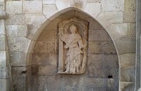 Iraklion Old Town at 26.6km (NW) It was made by Giovanni Sagredo between 1602-1604, part of it has been built in the Northwest corner of today's Loggia (Town Hall) and it is decorated with a carved female statue which according to Gerola's description probably with the left hand she was holding a shield, while with the right one a kind of a big hammer for display, representing the personification of Crete.
 Heraklion old town at 26.6km (NW) The Basilica of Saint Mark is one of the most important Venetian buildings-monuments in Heraklion. Today it houses the city’s Municipal Art Gallery. The Venetians, wishing to consolidate their dominance over their new colony (Heraklion) and to express their gratitude and love for their mother country, built a church in the city’s centre dedicated to Saint Mark, patron saint of Venice. The Basilica managed to survive various earthquakes which afflicted Heraklion over the centuries with only minor repairs. During the Turkish rule it was converted into a mosque, the Defterdar Mosque, named after Defterdar Ahmet Pasha, the head of the financial department. The Ottomans demolished the bell-tower of the basilica and raised a minaret in its place, which in its turn was taken down by the residents of Heraklion after the liberation of the island in their attempt to erase the unpleasant reminders and symbols of the Turkish occupation.
Image Library
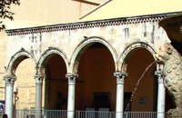
 Heraklion old town at 26.6km (NW) It is an essential public building in every Venetian city, which was not absent even from the colonies. For Candia, Loggia is considered to be one of the most elegant architectural monuments of the Venetian period, a representative sample of the palladian style. During the Venetian period, Loggia was the official meeting place of sovereigns and nobility where they discussed various topics that had to do with economic matters, commercial, and political ones.
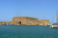 Iraklion Venetian port at 26.7km (NW) A seaside fortress situated at the entrance of the old harbour. It was built by the Venetians, before the construction of the new Venetian fortification, in order to protect the pier and the port. It took its last shape in the years between 1523 - 1540 replacing another construction destroyed by an earthquake. Image Library
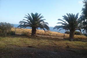 Krassas, Tsoutsouros at 26.7km (S) Palm House is a beautiful stone-built house on the south coast of Ceete. It is built on a tree-lined plot with panoramic sea views ,ideal for comfortable accommodation for 4 people. Its distance from the sea is only 300 meters.
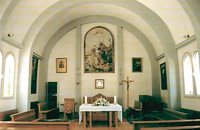 Heraklion Old Town at 26.7km (NW) The Heraklion Catholic church is located at 2, Patros Antoniou street close to the old port of the city. It is dedicated to Saint John the Baptist and was first built in 1888. In the 1959 earthquake the church suffered serious damages and had to be demolished and rebuilt. The pastor at that time, Father George Roussos, built the present church in 1961-1962. Father Petros Roussos, who was Pastor from 1980 to 2008 refurbished also the Capuchin Monastery that stands next to the church.  Iraklion city, Heraklion at 26.7km (NW) In the heart of the city center of Heraklion, opposite the church of Agios Minas, is the Museum of traditional music, instruments, research & documentation with the characteristic title 'Thirathen'. The Museum was founded in 2012 with its headquarters in the historic village of Krousonas, in the Municipality of Malevizi. In December 2023, it opened its doors to the public, in its new space in the center of the city of Heraklion. Heraklion Chamber of Commerce and Industry Iraklion at 26.7km (NW) The Heraklion Chamber of Commerce and Industry constitutes an advisory and consultatory body for both the State and its member-enterprises. Its objective is to represent, follow up and promote industry, manufacture, trade and services aiming at the growth of the local and national economy. It houses also The European Information Center. 9 koronaiou Str., GR 71202, Heraclion Crete, Greece PO BOX: 1154-71110 tel.: + 30 2810 229013 / fax + 30 2810 222914 e-mail: info@ebeh.gr, http://www.ebeh.gr 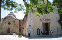 Iraklion at 26.7km (NW) Agia Ekaterini church and Exhibition of Byzantine Art and Ecclesiastical objects. A small sinaitic church of St. Catherine with a Basilica design, houses an exhibition with works of art from the Cretan renaissance. Among the exhibits are some of the most important icons of the Cretan School, ecclesiastical books and manuscripts, vestments, ecclesiastical vessels and relics, wall-paintings, wood-carvings and sculpture.  Iraklion Old Town at 26.7km (NW) The Cathedral of St. Minas:The small church of St. Minas did not meet the religious needs of the constantly growing Christian community, so the demand arose for the erection of a new cathedral. The plot for the new church used to be a garden that belonged to a Turk from whom it was bought. The architect was Athanasios Moussis and in 1862 the foundation stone of one of the most magnificent and impressive Greek churches was laid. The outbreak of the Cretan revolution of 1866 demanded the stopping of the building work which will continue in 1883 in order to be completed in 1895, when the inauguration of the exquisite temple took place. The church is of the cruciform type with a dome based on a high spandrel, while internally there are also elements of a three aisle basilica. It has two bell towers, one in the northeastern corner and the other in the southeastern one. The right aisle is dedicated to Apostle Titos and the left one to St. Ten Martyrs of Crete. The inside of the church has gone through many changes with new additions. With plans of the architect Anastasios Orlandos the woodcut icon screen was replaced by another one made of marble, the same happened with the bishop's seat. The religious painting of the church was assigned to St. Kartakis who followed faithfully the principles and the models of the Byzantine icon painting. The hundredth anniversary from the inauguration of the Cathedral Church of St. Minas (1995) was celebrated with every solemnity that is suited in an equal occasion and more specifically to one of the most glorious and imposing Greek churches. Image Library
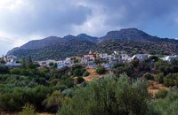 Ierapetra, Lassithi at 26.7km (SE) Mournies (GR: Μουρνιές - meaning: mulberry trees) is a village of the western Ierapetra. It is located north of Myrtos, and 25 kilometers away from Ierapetra at 275m (elevation), built on the southeastern outskirts of the Lasithi mountains, with beautiful views of the Libyan Sea and the plains of Ierapetra. It has a mild climate, without extremes, ideal both for permanent residence and for holidays. The landscape is hilly plenty of olive trees. In the 2001 census it had 83 residents. Mournies is a beautiful, historic, picturesque and traditional village with cafes, a square with a war memorial, an old fountain, and narrow streets branching off the main street of the village. Mournies was named after the Mulberry tree which however is not abundant in the area. 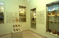 Iraklion town at 26.9km (NW) The history and culture of Crete, from the first centuries of the Christian era to our present time. An exceptional museum featuring a collection of extremely precious objects, a must see for every visitor to Crete. The museum is housed in a two storey neoclassical building, which was constructed in 1903 on the site of an earlier mansion.
 Krasas, Tsoutsouros at 26.9km (S) Seaside Houses located an hour drive (60kms) from Heraklion's airport at Tsoutsouros village. The houses are on the top of a headland separating two bays with magnificent beaches - the one almost private! - constituting a majestic scenery of virgin Crete with both sea and mountain view. Unique place for those who seek privacy, peace and romantic mood. The houses are fully equipped and have large shaded verandas. Prices from € 160/ night (2people) 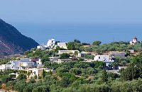 Ierapetra, Lassithi at 26.9km (SE) A stately village built in settlements, 22 km away from Ierapetra, at an altitudeof 225 m, next to the Ierapetra-Vianos provincial road. A green landscape,overgrown with olive trees, with an unlimited view of the Libyan Sea, to thesurrounding areas Koleitos, Kakon Oros, to the beaches Vatos and Kallikovrechtis.An almost abandoned village, with old houses built of stone, with chiseled doorframes and coats of arms bearing the Christian cross and proving its old gloryand history.Giannis Dimitromanolakis, an author from Gdohia, writes:“Gdohia sprouted right opposite the beach of the Libyan Sea. Nothing wouldhave been better for the pirates, who, like diabolical ghosts, emerged into thenight to kill and prey. The village’s history is dipped in blood, as it often sufferedfrom the raids of the pirates from the Barbary Coast. It took the name Gdohiafrom the catastrophes, from the verb “gdyno”, to skin, to set fire, to devastate.”Gdohia’s course in time has evidence of struggles, sacrifices and holocausts toshow. It was not only exposed to the pirates but it was situated on the naturalsouth passage going from the Viannos area to the Ierapetra area. This meantthat the hordes of barbarous conquerors burnt and devastated it, along withthe other Symiana villages, as they are called, in the West Ierapetra.Gdohia’s settlements are built leaving a distance between each other: KatoGdohia or Pitropiana, taking their name from the Epitropakis family livingthere, Pefkiana or Grysboliana, from the Grysbolakis family, Dimitromanolianafrom the Dimitromanolakis family, Daskaliana from the Daskalakis family,Papadiana from the Papadakis family. Great stonecutters, stoneworkers,famous for their art, Gdohia’s residents built the mansions of the whole areaand the famous bridge of Myrtos using stones from the quarries of Kolleitos.The miraculous church of Panagia (Our Lady) Evaggelistria of Gdohia, a workof art and a great ecclesiastical monument is also built by Gdohia’s residents.Gdohia village, once the seat of a Community, today a Local Department ofthe Municipality of Ierapetra, presents an exceptional sight-seeing interest. Itprovides natural landscapes, beautiful beaches, picturesque little churches onthe hills, a spacious square with palm trees, seats and a war memorial forthe fallen fighters of the liberation wars. In the 1881 census, 296 residents areregistered and 73 in 2001. Gdohia’s permanent residents, along with someforeigners’ families who have bought and renovated old houses, struggle forthe village’s development which gradually acquires the necessary infrastructures.A village with rich history and civilization, with vast olive groves, a nicemild climate, both during summer and winter, it hopes to come back to life.The old mansions, half-wrecked and burned in the German Occupation, standas if they were sculptures, a painting with the deep blue Libyan Sea serving asa background, narrate the flourishing, the glory and the history of Gdohia andwait to be inhabited again.
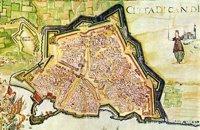 Iraklion at 26.9km (NW) The fortified enclosure of the Venetian Chandakas of the 15th century, which is still preserved today, is one of the most significant monuments of its kind in the whole Mediterranean basin. Triangular in shape, with its base at the sea, the mighty enceinte has a perimeter of about 5.5 kilometres. The hallmark of the defensive layout are the bastions, linked by curtain walls decorated at many points by escutcheons and the lion of St. Mark, symbol of Venetian omnipotence. The gates in the enceinte, which served to link the town to the countryside, still stand as important architectural monuments. To this day, the walls that withstood the Ottoman siege in the mid-17th century mark out the boundary of the old town. 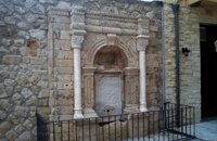 Iraklion Old Town at 26.9km (NW) It was built in the end of the 17th century. Today it is found behind the Historical Museum of the city. It is decorated with two columns with floral capitals, while in between them and inside an arched construction there is a marble plaque with relief decoration. The water was running from a specially made hole at the bottom of the plaque, into a marble basin.
Image Library
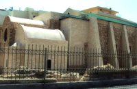 Iraklion Old Town at 26.9km (NW) It is situated approximately in the middle of the seaside wall. It was built from the first years of the venetian domination and belonged to the monastic order of Dominicans (Domenicani Predicatori). It was one of the most important and biggest Catholic monasteries of the city. The earthquake of 1508 caused a lot of damages to the temple. It consists of a long aisle which is roofed by a two slope roof and ends at a sanctuary roofed by two vaults. To the north and south wall of the temple there are windows of different types that were opened either during the Turkish period, or even earlier. Image Library
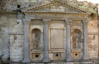 Iraklion at 27km (NW) The «General Provisioner» Antonio Priuli made it in 1666 and it is situated today behind the "Bodosakeio" Primary School (in the area of the Venetian Dermata Gate). He decorated it with round and square columns with Corinthian type capitals, while a triangular pediment crowns the whole construction. From both sides of the columns there are niches with their metopes elaborately decorated. In the middle of the fountain there is a Turkish inscription where there is a reference to the name of the Turkish pasha who managed to bring water again in the fountain.
 by Richard Ellis at 27.1km (W) 10th June- I packed up the tent early after a noisy night of competing dogs and was on the road by 0615. After 3 or 4 kilometres on a mix of dirt roads and tarmac roads, I managed to find the concrete road which is the official E4 (marked with paint on a concrete watertank) up from Pirgos and a couple of hours later I was in Venerato having a frappe in the café by the turn to Kerasia.. Distance:35.8km Time: 13.75 hrs. Mov av 3.9 km/hr Height overnight: 945m. Max. height: 1600m Petra & Fos pizzeria - cafe bar
Tsoutsouros at 27.2km (S) Delicious pizza in the wood heated oven, wonderful surroundings, ice cold beer, just by the libyan sea.
|

|
|
|
| ||

C
O
N
T
E
N
T
S
O
N
T
E
N
T
S