interkriti®
YOUR GATEWAY TO CRETE
HOME
CRETE FACTS
NAVIGATE
EXPLORE

Agia Galini
Triopetra
Kissamos
Chryssi Isl.
Agia Marina
Balos
Gavdos isl.
Georgioupolis
SAMARIA
IDA Mtn
Palaiochora
Agia Roumeli
Sfakaki
Bali
Kalamaki
Matala
Lassithi
Plateau Lendas
Tsoutsouros
Vianos
Myrtos
Sfakia
Plakias
Ierapetra
Makrygialos
ZAKROS
Vai
Sitia
Agios Nikolaos
Elounda
MALIA
Hersonissos
Gouves
Chania
Rethymnon
Heraklion
GORTYN
FESTOS
KNOSSOS
|
|
Crete
: Regional Interest
List Grid Map
Found
72
- Showing :
1 - 20
 Pediada, North - East Iraklion at 0km (N) The most popular tourist resort in Crete. Nice beaches, sights and facilities for all tastes and ages. Together with Malia, are the party places for young visitors. Close to Hersonissos there are three small traditional village, those of Piskopiano, Koutouloufari and Old Hersonissos.
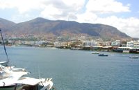
 Hersonissos, Iraklion, Crete at 2.1km (SE) The Cretan Open-air Museum 'Lychnostatis' aims to promote the understanding and awareness of the Cretan folk cultural heritage. Its scope lies on the Cretan Folk Tradition and Ethnology, the Cretan Nature and Environment and the Cretan Folk Culture. Located in Hersonissos, one of the principal tourist areas in Crete, the museum is, apart from a valuable tourist asset, an exemplary self - motivated conduct on tradition, culture and environment of the island. 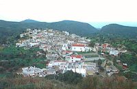 Gouves, Iraklion at 6.3km (SW) At a height of 320 m above sea-level, Kalo Chorio (GR: Καλό Χωριό) λιεσ 25.7 kms. from Heraklion, to the right at the cross-roads at km 16.7 on the National Road to Agios Nikolaos and on the road to Gouves- Koxare- Kalo Chorio. The present name does not figure in old Venetian documents, though there is a reference in the 1367 Duke’s archives of Chandax to a Kalo Horio, without however naming the district. The villagers maintain that the village was called Stravorina in the old days, and indeed there is a reference by Barozzi in 1577 to a village Stravorina in the district of Pediados. In the 1583 Register, the village Stravorina is mentioned as having 76 inhabitants and in the Turkish census of 1671 Istavrine is quoted as having 21 "charatsa" (A Turkish word referring to a tax paid by the head of each family; hence 21 families). However, Chourmouzis Vizantios in 1842 mentions Kalo Chorio, the present name was therefore given in the decade 1830-1840. The village counted 298 inhabitants in 1981 which is also the current population. The Maza hill-top, south-east of the village, is 457 metres high. According to archaeologists (among them the famous N. Platon) and on the basis of recent finds, the name Maza comes from pre-Hellenic years and means Mother Earth. The pile of stones on the hill was, according to N.Platon, a town from the 10th to the 8th c. BC. The highest part was undoubtedly used as a shrine in Middle-Minoan years, and clay figurines and offerings were found there. The shrine lay quite close to the town. The shrine stopped being used in Proto-Geometric years. Northeast of the village, by the country road that leads from Kasteli to Hersonissos, traces of ancient installations have also been found along with remnants of water tanks by a source that is still in use today. These water tanks, probably belonged to Hersonissos aqueduct, parts of which are still visible today in Aposelemi valley. There is as well an interesting gorge close to Kalo Chorio, in the valley of Aposselemis river, worth seeing for nature lovers. 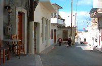 Gouves, Iraklion at 7.1km (W) Pano Gouves (GR: Πάνω Γούβες) is a village of the district of Pediada in the prefecture of Iraklion at a height of 100 metres above sea-level. It lies twenty kms away from Iraklion, to the right at 17.3 kms on the National Road to Aghios Nikolaos. The village is built on the western flanks of the Ederi hill (322 m.). The name comes from "edera" which means ivy and symbolises affection. The name Gouves, on the other hand, comes from Gouva and means a hollow in the earth. It also means, in Crete, a hole in which during the middle ages, people stored their wheat. The earliest reference we have of the village is that of "Guves" in 1387 documents of the Duke’s archives in Chandax. Later on, in 1577, Fr. Barozzi mentions "Guvos" in the district of Pediados, and then "Guves" in the 1583 Register, with 252 inhabitants. Finally, in 1630, Vassilikata refers to "Vuves’. This is the birthplace of the poet Ioannis Konstantinidis. There are several outstanding churches in the village, among them: Zoodochos Pigis, Aghios Giorgos, Aghios Ioannis and Panayia (dedicated to the birth of Our Lady). 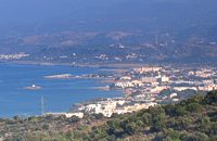 Pediada, North - East Iraklion at 7.3km (SE) The famous tourist resort with all types of accommodations. Great beaches and a lively party atmosphere particularly in August. Becomes pretty quiet and peaceful during the rest of the season and there is a nice and picturesque part of the old village that preserves the traditional character. Malia has also a significant agricultural production and is famous for its bananas, potatoes and bottled water.
 Gouves, Iraklion at 7.8km (W) At a height of 140m. above sea-level, this village has 142 inhabitants and is 22.5 kms away from Iraklion. According to the villagers, the name comes from the church of Aghios Nikolaos Skotino at the entrance of a cave. It was built at the end of the Venetian period. Today an extra wing has been added, dedicated to Aghios Charalambos. This church of Aghios Nikolaos Skotino presumably functioned as a "Hedge School" (or "Hidden School") under Turkish rule when education had been banned. When the locals said: "We are going to Skotino (which also means "darkness")", they meant they were going to school. Turkish administration refers to this place as Skotino Perasma in 1671. Very close to the village (1.5 km) the cave of Aghia Paraskevi draws crowds of tourists and is well worth a visit. 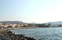 Gouves Beach, North - East Iraklion at 8km (W) Káto Goúves (GR: Κάτω Γούβες or simply Gouves) is a modern tourist resort with a complete tourist infrastructure to meet all demands. Organised beaches, large modern hotels, family apartments, restaurants, small tavernas, recreation centres, sports centre, shops, car and motorbikes for rent, small ports (marinas) for small boats, in a word Kato Gouves provides everything the visitors require to spend an agreeable and carefree holiday, enjoying the sunshine by day and the thrilling night-life in the numerous bars in the area. Just a few kilometers inland there are picturesque traditional villages, historic monasteries, caves and other natural beauties. Image Library
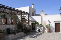 Voritsi, Gouves at 8.4km (SW) Kyra Eleoússa (GR: Κυρά Ελεούσα) Monastery is located close to the village Voroú or Voritsi. Due to its historical value the monastery and the outside area which covers 1000m has acquired protected status. Kyra Eleoussa is built according to feudal architectural style, and despite some interventions over the years it maintains many original architectural features. It is first referred in a document dating from 1606. At first it belonged to the monastery of Agia Ekaterini of Sinai but later it became part of Agarathos monastery. 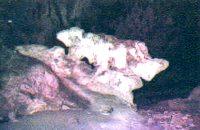 Skotino,Gouves, Iraklion at 8.6km (W) This is one of the three largest caves in the prefecture of Heraklion. It lies at half an hour distance to the north-west from the village of Skotino and is at a height of 225 m. above sea-level. The entrance to the cave is impressive: a large arch, 27 m wide and 10 m high. To the right one can see the ruins of an ancient chapel on which the modern chapel dedicated to Aghia Paraskevi was built. There is a feast held in front of the chapel on July 26th .
 Pediada, Iraklion at 8.8km (SW) To the east of Smari, at 400 m above sea level, with 99 inhabitants, Lagou (GR: Λαγού) is first mentioned in the Turkish census of 1671 with 4 haratsia (head tax). The journey to the village is charming getting you through areas of impressive wild landscape, and the typical old stone houses of Lagou, through the combined efforts of the members of the cultural centre, are being restored to their original traditional form so as to get the well deserved honour of being considered a protected traditional settlement. Image Library
 Gouves, Iraklion at 9km (SW) Vorou (or Voritsi) lies at a height of 230 m. above sea-level and counted 62 inhabitants in 1981 and 48 in 2001. It is 25 kms away from Heraklion. To get there, you follow the National Road to Aghios Nikolaos and at kms 17.7 turn right, taking the road Gouves-Skotino- Vorou. Nowadays it is known as Voritsi but this name is not official. The name Vorou, on the other hand, in the district of Pediados is mentioned by Barozzi in 1577. At the beginning of this century there lived a wise man and a healer in the village of Voritsi. His name was Giorgos Konstantoulakis and people flocked from all over to Crete to seek his advice.
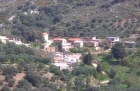
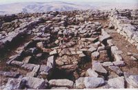 Pediada, Iraklion at 9.4km (SW) Smari has a very long history and was inhabited, according to reliable sources, from the proto-Minoan period onwards. The archeological relics in the Akropolis of the hill called Profitis Elias, excavated under the direction of the Archeologist D. Hatzi Vallianou, indicate a continuous human presence from the Middle-Minoan period to about 630 B.C. 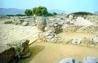 Archaeological site in Malia, Iraklion at 9.5km (E) The Palace of Malia, which covered an area of 7,500 sq.m. , was the third- largest of the Minoan Palaces and is considered the most "provincial" from the architectural point of view. The first Palace was built in 1900 BC and destroyed in 1700 BC when a new Palace was built. Following the fate of the other palaces in Crete it was also destroyed in 1450 BC. and the present ruins are mainly those of the new palace.
 Gournes, Iraklion at 10km (W) A modern competitive organisation, IMBBC (part of the Hellenic Centre for Marine Research - www.hcmr.gr) is widely recognized as one of the leading institutes in the Mediterranean. Its installations are located at Gournes, near Heraklion, Crete, where its laboratories, administration, library and conference facilities cover 1.500 m2. It has a wide range of state-of-the-art facilities needed to carry out its basic and applied research. 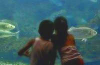 Gournes at 10.1km (W) The CretAquarium - Thalassocosmos (GR: Θαλασσόκοσμος) was officially opened in December 2005. It provides its visitors with a special experience, a trip to the underwater world of the Mediterranean Sea and its creatures. It is a unique park whose focus is on science, education, culture and recreation and whose goal is to promote, share and spread knowledge concerning the marine environment. Image Library
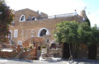
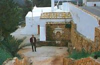
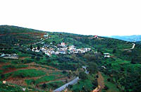
 Pediada, Iraklion at 10.2km (S) A beautiful small settlement, with 48 people, Epano Karouziana (GR: Επάνω Καρουζανά) lies at an altitude of 380m and is located at 40km from Herakleion. It is mentioned for the first time in 1842, its name was taken by a family name "Karouzos" common in the village. The village offers a spectacular view, picturesque paved lanes, traditional kafeneia and taverns and is a popular with tourists, especially in the summer when many Cretan evenings are organized with local music and dance. 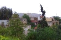 Pediada, Iraklion at 10.5km (S) Anbother beautiful small settlement, with 38 people, Kato Karouziana (GR: Κάτω Καρουζανά) lies at an altitude of 300m and is located at 49km from Herakleion and 1km from Epano Karouzana. It offers a spectacular view to the Kastelli plain, picturesque paved lanes, traditional kafeneia and taverns and is a popular with tourists, especially in the summer when many Cretan evenings are organized with local music and dance. 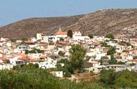 Pediada, Iraklion at 10.8km (SW) The village of Smári (GR: Σμάρι) is a traditional Cretan village, only 10 km away from Kasteli and has 375 inhabitants. In it you will find beautiful old stone houses that have been restored, picturesque little alleys, ruins of older buildings and pottery workshops where you can purchase copies of Byzantine and Minoan ceramics. There are also some interesting churches with wonderful frescoes like the one dedicated to Sotir Christos, the Koimisi tis Panagias and Agios Giorgos. The earliest reference to the village of Smari dates back to 1375. There is a lively Cretan feast on July 20th in honour of Profitis Ilias, with much rejoicing, singing and dancing. 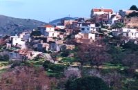 Pediada, Iraklion at 10.9km (S) Bizariano (GR: Μπιτζαριανό) is a traditional small village of about 24 inhabitants in the area of Kasteli Pediada, 320 m above sea level and about 3 km to the north of Kasteli on the road to Hersonissos. A pretty village with stone houses, graphic lanes and courtyards covered in flowers. It is first mentioned in 1881, as Bizariano, Municipality of Kasteli, with 55 Christian inhabitants. In 1951, it changes its name to Pigi. Its first name is that of a family, Bizariano. Close to the village, in a beautiful spot full of lush vegetation, evergreen plane trees and gushing water, stands the ancient church of Agios Pandeleimonas, with its three naves. Two rows of arches supported by columns without capitals separate the naves. Another column is made exclusively of capitals, apparently brought in from other churches or temples. Practically all the middle outside wall is decorated with inscriptions, Byzantine reliefs and crosses. Agios Panteleimon (External) Agios Panteleimon (External) Agios Panteleimon (interior) The artistic highlight of the church of Saint Panteleimon are its fresco scenes painted on the walls which are among the oldest in Crete, although very few frescoes remain. In the lower section of the arch, there is the representation of the three Hierarchs, shown on full length, with vertical inscriptions on it. On the two side walls there are the representations of Saints in a colossal size. These scenes were designed to be a source of biblical education to the faithful, who would have been illiterate at that time. Image Library
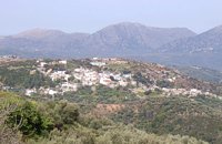 Pediada, Iraklion at 11.1km (S) Askoi (GR: Ασκοί) is small village in the municipality of Kasteli has 315 inhabitants. It lies in the foothills of the Dikti mountain, 11 km to the east of Kasteli and 8 km from Lyttos. Fr. Barozzi mentions it as Ascus, in the Pediada district, in 1577. Recently a ritual clay figurine of the Mid-Minoan period was fortuitously unearthed on a peak close to the village. The remains of a large building belonging to a peak sanctuary have been excavated at Amygdalokefalo to the NE of the village. A reference in a contract of 1271, mentions how Petri Comarii from the village (casali) Maski owes Ruggerino Temisano, resident in Chandax, 25 «mistata» of good Cretan wine from his vineyards in Maski. Among other natural beauties, the ravine at Aski is well worth seeing. On December 4th the village has a typical Cretan feast to honour Agia Varvara. And as in every Cretan village, raki and ‘mezedes’ are always available at the kafeneions. Image Library
|
||
|
| ||


';top.fotoWin('/dbsf/pages_pics/15/1522205/aposselemi_gorge01.jpg','');)
)
)
)
C
O
N
T
E
N
T
S
O
N
T
E
N
T
S