interkriti®
YOUR GATEWAY TO CRETE
HOME
CRETE FACTS
NAVIGATE
EXPLORE

Agia Galini
Triopetra
Kissamos
Chryssi Isl.
Agia Marina
Balos
Gavdos isl.
Georgioupolis
SAMARIA
IDA Mtn
Palaiochora
Agia Roumeli
Sfakaki
Bali
Kalamaki
Matala
Lassithi
Plateau Lendas
Tsoutsouros
Vianos
Myrtos
Sfakia
Plakias
Ierapetra
Makrygialos
ZAKROS
Vai
Sitia
Agios Nikolaos
Elounda
MALIA
Hersonissos
Gouves
Chania
Rethymnon
Heraklion
GORTYN
FESTOS
KNOSSOS
|
|
Crete
: Regional Interest
List Grid Map
Found
31
- Showing :
21 - 31
 Apokoronas, Hania at 20.8km (SE) The traditional little village of Vrisses lies approx. 35 km from Chania town. The old village square with its tall plane trees, the tavernas and kafenions is the perfect place to relax and enjoy the lush green landscape by the river Vrissanos and taste the renowned and particularly delicious local yogurt.
 Omalos, Hania at 21km (SW) Xylóskalo (Ksyloskalo GR: Ξυλόσκαλο) is the point where the Samarian gorge starts. It is located on the Lefka Ori (White Mountains) in the plateau of Omalos, 43 km from the city of Hania at 1250m above sea level. It is also the entrance to the gorge. There are two tourist lodges where visitors can rest and have food or coffee and take panoramic pictures of the gorge and the White Mountains. There is also the information center of the National Park and a parking area. Xyloskalo means the "wooden stair" and refers to a wooden staircase built by the locals in order to facilitate the entrance to the gorge as at this point the cliffs are very steep. Today this part of the path is made of stones and it has a wooden handrail. About 1km before Xyloskalo a dirt road leads, after 5 km, to the Kallergis mountain lodge at 1680m a.s.l.  Apokoronas, Hania at 22.5km (E) The community of Kefalas (GR:Κεφαλάς) is situated in Apokoronas, Hania, approximately 4 km to the east of Vamos. During the Venetian occupation higher and lower Kefalas were classed as two separate villages, however, today they have become one. It is a large village built in an outstanding position facing the sea with architecture dominated by the influence of the early and late years of the Turkish occupation. This influence is well preserved despite the existence of other architectural styles. The church of Timios Stavros (16th century) is the oldest building of the village while the more recent churches of Panagia, Agios Antonios, and Michael the archangel, works of the reputed Kefalas craftsmen, are examples of folk architecture of the 19th century. A further example of the work of the same craftsmen is the Public School of Kefalas, which in accordance with the decision of the county council of Hania will house the Environmental Educational Centre of the prefecture, a foundation that will play a definitive role in the development of the municipality of Vamos. Other interesting communities are Paleloni and Drapanos in the direction of Kokino Horio. The road from Paleloni leads to Embrosgialo, a relatively easily accessible place, along the steep coastline, which extends to Georgioupoli.  Sfakia, White Mountains at 26.1km (SE) It is located at an altitude of 750 m, 50 km SE from the city of Hania and 20 km from the village of Vryses. Its population is approximately 500 people. The small villages that constitute the community of Askifou are Kares, Ammoudari, Goni and Petres. The most touristic organised of them is Ammoudari with restaurants, gas station, and some rooms for rent.
 Apokoronas, Hania at 26.2km (SE) Georgioupolis lies at the northern coast of Crete, about 35km away from Hania and 20 km from Rethimno. It is a nice coastal village situated at the bay of Almiros, in a lovely green scenery. It has a sandy beach and attracts quite a few visitors in the summer time. It provides all the necessary facilities to the tourists.
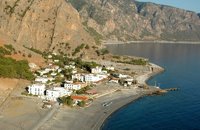 Sfakia, South Hania at 28.4km (S) Agia Rouméli (GR: Αγία Ρουμέλη)is a small fishing village, approximately two kms from the ending of Samaria Gorge. It is accessible only by boat from Paleohora, and from Hora Sfakion. It serves mainly as a stopover for visitors coming down the Samaria Gorge, and waiting for the boat to take them to Sfakia or Paleohora. However those who decide to stay for a couple of days or more will find apart from the unique scenery, a great beach with crystal clear water, plenty of interesting walks and a good choice of accommodations, taverns, cafés and stores. The place is also rich in history as it was inhabited since the antiquity. It is the site of the ancient city of Tárra (GR: Τάρρα), a famous cult place, that flourished from the Classical to the Roman times. Image Library
 Kissamos at 28.7km (W) A small village 21km away from Kastelli Kissamou,at 340 m. a.s.l with 57 permanent residents. The village is mentioned by Fr. Barozzi since 1577. A little before the village of Sassalos, starts the gorge of Salasse, a small one which leads to Tyflos river, and is worthy to walk.
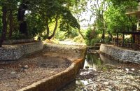
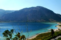 Apokoronas, Hania at 28.9km (SE) Crete's only freshwater lake, Lake Kournás (GR: Λίμνη Κουρνά), is relatively large, with a perimeter of 3.5 km. Although almost all touristic leaflets say that it is possible to walk around the lake, that is not true. At least not at the end of the rain season (winter). There is a nature preserve on the Southwest of the lake. But there is a rustic road from the North of the lake to the Hills on the West of the lake too. Image Library
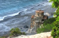 Sfakia, South Hania at 28.9km (S) Ágios Pávlos (GR: Άγιος Παύλος)is a beach on the shores of Sfakiá between Agia Rouméli and Loutró. The pine trees from the high cliffs above almost reach the sea and form a unique landscape. The beach is sandy with pebbles with no facilities except for a small tavern. It can be reached only on foot ( about 1 hour walk from Agia Roumeli) or by boat. The picturesque small church of Agios Pavlos (Saint Paul) a byzantine basilica of the 10th century A.D. with frescoes, lies just a few meters from the sea. It is built with stones from the beach itself on the spot where Saint Paul reportedly baptised people on his way to Rome.
Image Library
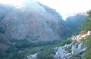
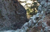 Sfakia, South Hania at 29.2km (SE) The ravine begins from the last houses of the village of Imbros and 8 km after it ends at the village of Komitades. Its crossing is smooth and entails no danger...
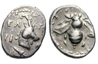 Selino, Hania at 29.2km (SW) Elyros ("Έλυρος" in Greek) is an ancient city, located in southwest Crete, in Kefala Hill, near the village Rodovani and is presently unexcavated. Elyros was flourishing at least as early as the Greek Classical Period, e.g. 500 to 350 BC. In the Classical Period Elyros was the most important ancient city in southwestern Crete, having about 16,000 inhabitants. It was an industrial and commercial city with large weapons production. Syia and Lissos were its harbours. Apollo, Phylakides and Philandros, sons of Apollo and nymph Akakallida, were worshiped there. In the third century BC Elyros was at war with Kydonia, an important center of Cretan power, located in the modern city of Chania. The citizens of Elyros sent to the Delphi Oracle, a bronze votive complex that represents a goat feeding the sons of Apollo when they were infants. It is also one of the thirty cities that signed the decree with Eumenes B’ in 183 BC.Elyros was also important during Roman times. A Roman statue, the Philosopher of Elyros was recovered here and is now in the Archaeological Museum of Chania. During Byzantine times, Elyros was the seat of an Archbishop and the remains of the bishopric church, a sixth century basilica, can still be seen in the centre of the old city. Robert Pashley was the first who identified the location of the city, near village Rodovani. Thenon studied more carefully the ruins of the city and discovered the inscription that says: “it seemed to the city of the Elyrians”. The output of its mint consists of silver drachms from the 3rd c. BC, which depict a wild goat and a bee; in addition to their function as religious symbols, these undoubtedly hint at the stock-raising activities in the region, particularly to this kind of wild goat, which can still be found in great numbers on the island. The bee also has reference to the abundant honey-production of Crete. |
||
|
| ||


;)
;)
;)
C
O
N
T
E
N
T
S
O
N
T
E
N
T
S