interkriti®
YOUR GATEWAY TO CRETE
HOME
CRETE FACTS
NAVIGATE
EXPLORE

Agia Galini
Triopetra
Kissamos
Chryssi Isl.
Agia Marina
Balos
Gavdos isl.
Georgioupolis
SAMARIA
IDA Mtn
Palaiochora
Agia Roumeli
Sfakaki
Bali
Kalamaki
Matala
Lassithi
Plateau Lendas
Tsoutsouros
Vianos
Myrtos
Sfakia
Plakias
Ierapetra
Makrygialos
ZAKROS
Vai
Sitia
Agios Nikolaos
Elounda
MALIA
Hersonissos
Gouves
Chania
Rethymnon
Heraklion
GORTYN
FESTOS
KNOSSOS
|
|
Crete
: Regional Interest
List Grid Map
Found
75
- Showing :
41 - 60
 Iraklion at 14.1km (NW) This 2 km long sandy beach was for years and still is the favorite beach of the people of Heraklion town. It is named after the river "Karteros" which outflows at the west end of it near the airport. The water is clean, the seabed is sandy with smoothly shelving and swimming is safe. The access is free in most parts except for some areas that are reserved for military personnel and the municipal beach "Akti" where visitors should pay an entrance fee in order to use the facilities. At the east end there are some very good taverns offering fresh fish among their specialties and are very popular with locals and tourists alike.
Image Library
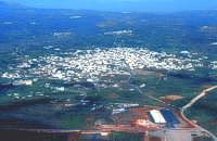 Central Iraklion at 15.8km (SW) The town of Arkalochori (GR: Αρκαλοχώρι) with a population of 2.881 is located 33km away from Heraklion, on the provincial road linking Heraklion and Viannos, at 395m above sea level. Its inhabitants are mostly involved in agriculture, but in commerce and arts as well. Arkalochori is one of the most developing towns in the prefecture of Iraklion both in economic and cultural sectors and is the administrative center of the area. Events such as the Pancretan Agricultural and Commercial Exhibition, that takes place here are of great significance and interest for the whole island. The town offers a full range of modern facilities to its residents and visitors.
Image Library
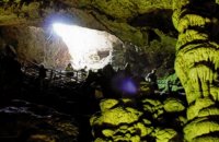 Psychro, Lassithi Plateau at 15.9km (SE) The cave of Psychro is one of the most important cult places of Minoan Crete. The excavators and several scholars identify the cave as the famous "Diktaian Cave", where Zeus was born and brought up with the aid of Amaltheia and the Kouretes, and which is connected with myths as this of the seer Epimenides who "slept" here, or the coupling of Zeus with Europa.
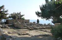
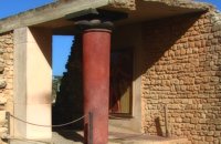 Palace and Archaeological site at 16.2km (W) The famous Palace of king Minos and the centre of the Minoan civilisation 5km south of Iraklion. The Great Palace covered an area of 20.000 sq. meters and had 1.400 rooms. Every section of the Palace had a specific use. In the west side of the Palace were the chambers of the ceremonies, of the administration and of the public storehouse...
Image Library
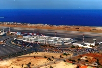 Iraklion ( Nea Alikarnassos) at 16.4km (NW) Heraklion International Airport, "Nikos Kazantzakis" (Greek: Κρατικός Αερολιμένας Ηρακλείου, "Νίκος Καζαντζάκης") or Nikos Kazantzakis International Airport (IATA: HER, ICAO: LGIR) is the primary airport on the island of Crete, Greece. It is located about 5km from the main city of Heraklion. Heraklion International Airport is is one of the biggest in Greece and receives approximately 15% of the total tourist traffic of Greece. There are many airlines currently operating flights from Athens and Thessaloniki to Iraklion (Olympic Airways, Aegean Airlines and others), while during the high season there are flights from/to Rhodes, Mykonos, Santorini and other Greek islands. There are also international airlines that connects Iraklion to other European cities. During the summer season there are numerous chartered flights to Iraklion from all over Europe (mainly Germany, the United Kingdom, Russia, and Holland). During the summer months there is a huge increase in air traffic that peaks in August (approximately 130 flights per day). Major car-rental companies have desks at the airport. Taxi and public bus are available for transfer from/to Iraklion. 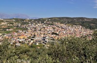 Archanes, Iraklion at 16.4km (W) A small traditional town (~4000 people) 15 km south of Iraklion on the foot of the sacred mountain Yiouhtas. Renowned for its excellent wine (from the varieties: vilana, kotsifali and madilari) and the archaeolocical sites and caves. In 1912, Xanthoudides noted the importance of Archanes, but Sir Arthur Evans was the first to characterize the site as palatial, declaring that Archanes was likely a Summer Palace for the Knossos kings. Spyridon Marinatos and N. Platon excavated minor areas in the region, but nothing supported Evans' theory. In 1964, J. Sakellarakis dug trial trenches at the Tourkoyeitonia site and uncovered the first evidence of a palace site. Since 1966, Archanes has been excavated by the Greek Archaeaological Society under the supervision of John Sakellarakis and Efi Sapouna-Sakellarakis. Links: http://www.archanes.gr/(GR) Image Library
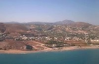
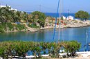 Mirabello, Lassithi at 16.5km (E) The village of Sissi, a picturesque village 40 km east of Heraklion and 25 km west of Ag. Nikolaos. Sissi is a beautiful fishing village with strange nature. On one side of the village the nature is wild, with a small river flowing into the sea, a number of palm trees on its banks, ducks and geese swimming peacefully. On the other side there are sandy and gravel beaches, caverns in the rocks and deep clear water, full of many kinds of fish. A place that gathers the nature of different places of Crete.
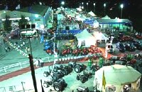 Arkalohori at 16.6km (S) A modern exhibition and congressional centre offering 8000 square meters of total space, 1500 of them being indoors. Among many events that take place in this centre is the Pancretan Agricultural and Commercial Exhibition of Arkalochori held every two years at the end of August. The exhibition attracts a large number of enterprises, manufacturers and services participating and is being visited by over 30,000 visitors from all over Crete. It is considered to contribute essentially in the rapid commercial and cultural development of the wider area. Photo The Municipal Open Theatre Located in the area of the exhibition centre the theatre is of semicircular shape with a capacity of approximately 1000 seats. The facility offers also a canteen, toilets, dressing-rooms for the actors, store room of scene and backstage.The cultural events that the Municipality organises every summer, attract visitors not only from the wider area but also from Iraklion city. Photo Photo 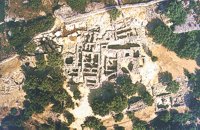 Archanes at 16.8km (W) Excavations at Phourni have brought to light 26 buildings, most of which had funerary use. The cemetery was used from 2400 B.C. until 1200 B.C. and each complex had more than one architectural phase. Most of the funerary buildings were used for many decades and contain successive burials. Excavations were begun in 1964 by Efi and John Sakellarakis and have been continued until today (1995) with short interruptions. Most of the buildings are preserved in good condition. 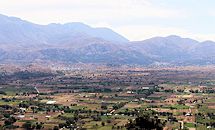 Lassithi, Dikti Mountains at 17.4km (SE) The Lassithi Plateau (GR: Οροπέδιο Λασιθίου, Oropedio Lasithiou), is a high endorheic plateau, located in eastern Crete, Greece on the mountain range of Dikti at an average altitude of 840 m, and in a distance of around 55km from Heraklion and 50km from Agios Nikolaos. The plateau is elliptical in shape with an E-W axis of 11km and the N-S of 7km. The plateau of Lassithi is renowned for its exceptional agricultural produce, the thousands (almost 15000) windmills that used to be there in the past, its significant historical role and for the unique cave of Psychro also known as "Diktaion Andron". Image Library
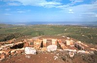 Archanes at 17.9km (W) Anemóspilia (GR: Aνεμόσπηλια). Anemospilia is an archeological site at the northern foot of Mount Yuchtas, in the prefecture of Heraklion in Crete. A rectangular building has been found which dates from the Minoan era and was destroyed by an earthquake in the 17th century BC. The building with three narrow chambers, each opening into a long corridor to the north, which extends along the whole width of the building. The area is enclosed with a stone wall and the whole structure has been interpreted as a shrine; in the central room was found a "xoanon" (statue) of the deity worshiped here. In the west room, where the altar stood, was uncovered, according to the excavator, the first human sacrifice to have ever taken place in Minoan times. (although this view has been challenged). The building at Anemospelia was used for only half a century, as it was suddenly destroyed by an earthquake in the middle of the 17th century B.C. The site was excavated in the summer of 1979 by John Sakellarakis.  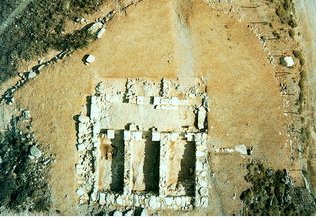 Aerial view 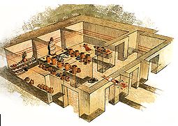 Shrine model Links: Minoan Religion (Foundation of the Hellenic World) 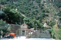 Mirabello, Lassithi at 18.2km (E) At the side of the gorge of Selinari, at the 42 km. of the national road Iraklion - Agios Nikolaos is the small old chapel and the newly founded monastery of Agios Georgios Selinaris. In the monastery there is also a home for the aged founded in 1963. The small chapel was probably founded early in the 16th century AD, and ever since it is a place of worshiping. The people passing through the chapel stop to light a candle to the saint. The chapel is considered miraculous, there are various legends concerning miracles related either with healing of sick people or with divine punishment of people that did not pay the respect due to the saint.
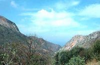 Selinari, Vrahassi at 18.4km (E) Near the beautiful village of Vrahasi there is the imposing gorge of Selinari, formed by the mountain of Anavlohos (625 m) to the north and the mountain Fonias o Detis (818 m) to the south. The symbol of Crete, the Cretan wild goat (Agrimi or kri-kri) and the Griffon Vulture are two rare species that used to reside in the gorge. The authorities in Vrahasi intend to establish a center of protection of the local fauna and flora at the gorge of Selinari and to develop a wildlife station, to provide observation of the Griffon Vulture colony at the east side of the gorge of Selinari. The hunting is forbidden in an area covering 10 sq.km. around the gorge. 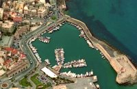 North - Central Crete at 18.7km (W) Iraklion (Heraklion or Herakleion GR: Ηράκλειον) is the largest urban centre in Crete, the capital of the region and the economic centre of the island. The first European civilisation, the Minoan civilisation, flourished on this land 5000 years ago. Currently the population of Iraklion is approximately 150.000 people. It is a very dynamic and cosmopolitan town, particularly during the summer period when thousands of visitors can be seen shopping in the market or visiting the museums and other places of interest. Today Heraklion is the top choice for tourist destinations in the Mediterranean. The city is also the commercial and scientific centre of the island. During the last 20 years the city has made remarkable progress in the academic and technological fields...
Image Library
 Archanes at 18.7km (SW) The Minoan villa at Vathypetro was most likely the residence of a local ruler. Its architecture is comparable to that of a "Little Palace": it has a central and west court, a small tripartite shrine, a three-columned portico, storerooms and workshops. It seems that the construction of the building was never completed. Interesting elements of its architecture are the installations of a wine-press in the south wing and an oil-press in the courtyard. 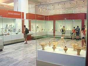 Heraklion city at 19.5km (W) The most magnificent collection of Minoan art and culture in the world, unique in beauty and completeness is housed in this museum. The exhibiton of the museum is organized in chronological order, ranging from the Neolithic period to the Roman era (4th century A.D.) and geographically, according to the provenance of the finds.
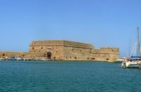 Iraklion Venetian port at 19.8km (W) A seaside fortress situated at the entrance of the old harbour. It was built by the Venetians, before the construction of the new Venetian fortification, in order to protect the pier and the port. It took its last shape in the years between 1523 - 1540 replacing another construction destroyed by an earthquake. Image Library
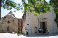
 Iraklion Old Town at 19.8km (W) With the recovery of Crete from Nikiforos Fokas (961AD), the seat of the bishopric is transferred from Gortyna to Chandakas, which became the capital of the island. The new cathedral, which is the most established and largest in the city, is dedicated to the Apostle Titos. Here, amongst other relics, there are gathered the Holy Skull of the Apostle and the miracle working icon of Messopapaditissas. Image Library
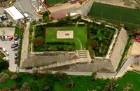 Iraklion at 19.9km (W) The bastion heart shaped in plan with an acute angle, has two "piazza bassa" and one cavalier. It defines the southeast and the highest part of the fortification. Its name is due to Gabriele Tadini Martinego (1520) who started the construction of a circular tower at the place of the later bastion. It was one of the strongest bastions (the others were that of Pantocratora and that of Vittouri) which also suffered the main attack and most of the bombardment from the Turks. On the top of the bastion itself there was made a cavalier (which looks like a smaller bastion), whose main purpose was the better defense and control of the area around the bastion. The grave of Nikos Kazantzakis, the famous Cretan writer, is situated on the highest point of the Venetian fortification at the Martinego cavalier. The inscription by the wooden cross reads: " I hope for nothing. I fear nothing. I am free ", a phrase taken from "The Odyssey" which Kazantzakis considered as one of his most significant works. The playgrounds of the Academy of the local football team "Ergotelis" are located today on the main bastion and in the ditch around the bastion are the botanical gardens of the city. Image Library
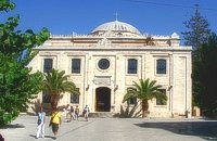
 Iraklion at 20km (W) Agia Ekaterini church and Exhibition of Byzantine Art and Ecclesiastical objects. A small sinaitic church of St. Catherine with a Basilica design, houses an exhibition with works of art from the Cretan renaissance. Among the exhibits are some of the most important icons of the Cretan School, ecclesiastical books and manuscripts, vestments, ecclesiastical vessels and relics, wall-paintings, wood-carvings and sculpture. |
||
|
| ||


)
)
)
C
O
N
T
E
N
T
S
O
N
T
E
N
T
S