interkriti®
YOUR GATEWAY TO CRETE
HOME
CRETE FACTS
NAVIGATE
EXPLORE

Agia Galini
Triopetra
Kissamos
Chryssi Isl.
Agia Marina
Balos
Gavdos isl.
Georgioupolis
SAMARIA
IDA Mtn
Palaiochora
Agia Roumeli
Sfakaki
Bali
Kalamaki
Matala
Lassithi
Plateau Lendas
Tsoutsouros
Vianos
Myrtos
Sfakia
Plakias
Ierapetra
Makrygialos
ZAKROS
Vai
Sitia
Agios Nikolaos
Elounda
MALIA
Hersonissos
Gouves
Chania
Rethymnon
Heraklion
GORTYN
FESTOS
KNOSSOS
|
|
Crete
List Grid Map
Found
77
- Showing :
61 - 77
 Kenourgiou, Iraklion at 24.1km (N) Agios Thomás (GR: Αγιος Θωμάς) lies at 530 m above sea level. It is 30 km away from Heraklion and has a panoramic view over the whole area to the SE of Aghia Varvara. Agios Thomas is a very old village and the first reference we have of it, is in a document of 1371, where it is quoted as a feudal property of Petrus de Medio, and again in a document dated 1380. Later, it figures in all the Venetian censi of the 16th and 17th centuries. In 1881, and in 1900, it figures as part of the Megali Vrisi municipality, with 344 inhabitants. From 1920, it figures in all the censi as a community with a continuously growing number of inhabitants. Nowadays there are over 800 inhabitants. 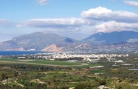 Messara, Iraklion South at 24.7km (NW) The town of Timpaki (GR: Τυμπάκι) is located in the west edge of the plain of Messara, 65.3km away from the city of Iraklion. It is a rich and busy town with significant economic activity especially due to the early vegetables production in the wider area. There are banks, a post office, medical centers, stores, schools, hotels, restaurants, ect to cover both the needs of the locals and visitors.
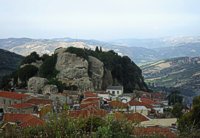
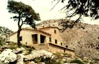
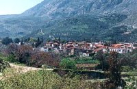
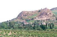 Kenouriou, Iraklion at 24.8km (N) Doúli (GR: Δούλι) is a village in Kenouriou county, located 38 km from Iraklion at an altitude of 440 m above sea level. The earliest reference to it, is to be found in the Duke's Archives of 1372, where it is mentioned as the feudal property of Nic. Venerio. The name figures in all the Venetian censi of the 16th and 17th centuries, as well as in the Turkish (1671) and Egyptian (1834) censi. In 1881, Douli forms part of the municipality of Megali Vrisi with about 170 inhabitants, and again in 1900 with only 21 inhabitants. As of 1920, Douli is a commune in its own right, and today Douli has about 240 residents. The patron saint of the village is Aghios Panteleimonas and the feast of the Saint is celebrated on July 27th.A visit to the old church of Aghios Nikolaos is also a must. For those interested in paleontology, there are fossils to be found at the location 'Pirgos'.  Kenourgiou, Iraklion at 24.9km (N) Priniás (GR: Πρινιάς) is a small village located 35km southwest of Iraklion town and 4km from Agia Varvara, at a height of 610 m above sea level. The village of Prinias lies on the border of three regions: Malevizi, Kenouriou and Monofatsi, and is recorded as forming part of all three regions in the censi. 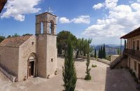 Zaros at 25km (N) This is one of Crete's most famous monasteries. It played an important role during the years of the Cretan Renaissance, both in the letters and the arts, and, during the last centuries of Venetian rule, it was known for its many scholars, artists and venerable monks.
 Voriza, South - West Iraklion at 25.3km (NW) Close historical bonds link this monastery to that of Vrontisiou. The Varsamonerou Monastery lies in the surrounding fields of the village Voriza, 54.5 kms from Heraklion. The monastery is abandoned and, though its cells have been destroyed, its church has some of the most remarkable wall paintings in Crete.
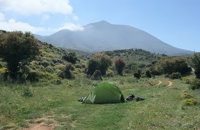 by Richard Ellis at 26.3km (N) 11th, 12th and 13th June- We had made camp in the yard beside the Aghios Ioannis chapel at Rouvas but, the following morning, it was quite clear that I wasn’t going to go any further on foot until the shin splint had settled down a bit. Minor surgery on the blisters exposed the full extent of those problems and I hung them out to dry in the sun while Triantafyllos went off looking for paths to put on his maps. I think I was lucky not to get infected blisters but Betadine is a great resource which I used extensively.
 by Richard Ellis at 26.3km (N) 14th June- The walk up from Rouvas is quite straightforward; once you have walked back down the stream from the Rouvas picnic area and turned right (north) up the dry river bed for two hundred yards, you scramble up a short, easy rock section (well sign posted) before the path continues up through open oak woodland (the Rouvas Forest) heading first for the Duo Prinoi chapel, which has a water tap, and then later up and over a ridge, beyond which a small dry water course leads up a steep sided valley to the flat lands of the Nidha plateau. Distance:12 km Time: 4.75 hrs. Mov av 3.7 km/hr Height overnight: 1,360m.  Monofatsi, South Iraklion at 26.9km (E) Maridaki (GR: Μαριδάκι) is a small coastal hamlet in the bay of Tsoutsouros on the southern coast of Iraklion prefecture. It is built at the end of the gorge of Ahendrias.
Image Library
 East Ida mountain, Iraklion at 27.7km (N) Prinos refuge at Prinos on Psiloritis mountain (Ida), is at 1100 metres. It can sleep 25 people, it has cooking facilities, two wood burning stoves for heating and a rainwater tank. Access is through the village of Ano Assites in Malevizi around 22km from Iraklion. From there a two kilometres of dirt road leads to a place called Melisses and then a one-and-a-half hour walk along a footpath signed with red marks, to the refuge. Prinos hut was built in 1962 and was renovated around 1992. It is run by the mountaineering club of Heraklion. The view from Prinos to the north and east is great. 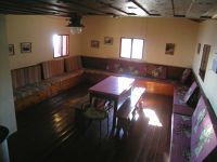 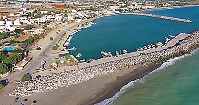 Messara bay, Iraklion South at 27.9km (NW) Kokkinos Pirgos (GR: Κόκκινος Πύργος) is a small coastal community, 2km away from Timbaki with a nice, long sandy beach, one of the longest in Crete, and a clear transparent sea. The part of the beach to the north west of the harbour is called Makrimaliana (or Kakoskalo) and the south east part of it is called Katalyki . The harbour in front of the village of Kokkinos Pirgos, offers docking facilities for sailing and fishing boats. There are hotels, restaurants, bars, etc. across the harbour and along the beach. You can always find good fresh fish in the taverns of the village. Kokkinos Pirgos (meaning red tower) , took its name from a castle that use to be there during the Middle Ages, which was built by red clay earth.
Image Library
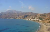 Monofatsi, South Iraklion at 28.2km (E) Tsoutsouros (GR: Τσούτσουρος) is a small village on the southern coast of Iraklion prefecture, with lovely beaches and a small harbour. The ancient city of Inatos, used to stand were Tsoutsouros is now. Inatos served as a port to Priansos a renowned city - state of the Hellenistic time, located near the village of Kasteliana. Tsoutsouros is a popular tourist resort especially with Greek families. There are many taverns and cafes most of them around the small harbour, and a good choice of apartments and hotels along the beach. Image Library
Petra & Fos pizzeria - cafe bar Tsoutsouros at 28.3km (E) Delicious pizza in the wood heated oven, wonderful surroundings, ice cold beer, just by the libyan sea.
 Malevizi, Iraklion at 28.9km (N) Ano Asites (GR: Ανω Ασίτες) lies 24km from Iraklion and 6km from Agios Myron at 480m a.s.l with 423 inhabitants. A big part of the surrounding area is covered by forest on the eastern side of the mountain Psiloritis. Near the village there is the Byzantine chapel of Agios Antonios located in the ravine with the same name a place of exceptional natural beauty. From here passes the European Hiking Path (E4) which leads to the shelter "Prinos" ( of the Mountaineering Club of Iraklion - altitude 1100 m a.s.l.) located in a holly (=prinos) forest.  Krassas, Tsoutsouros at 29.5km (E) Palm House is a beautiful stone-built house on the south coast of Ceete. It is built on a tree-lined plot with panoramic sea views ,ideal for comfortable accommodation for 4 people. Its distance from the sea is only 300 meters.
 Krasas, Tsoutsouros at 29.6km (E) Seaside Houses located an hour drive (60kms) from Heraklion's airport at Tsoutsouros village. The houses are on the top of a headland separating two bays with magnificent beaches - the one almost private! - constituting a majestic scenery of virgin Crete with both sea and mountain view. Unique place for those who seek privacy, peace and romantic mood. The houses are fully equipped and have large shaded verandas. Prices from € 160/ night (2people) 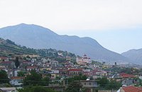 Malevizi, Iraklion at 29.8km (N) Kato Asites (GR: Κάτω Ασίτες lies 23km from Iraklion and 5km from Agios Myron at 450m a.s.l with 1113 inhabitants. Beautiful town with traditional architecture especially the quarters "Notiko", "Prinos" and "Kastella" close to the monastery of Gorgolaini. Other interesting sights are: The thermae of the king of Prinias, The uninhabited settlement of Nisi with traditional houses, the caves "Lesta spilios" at Marias aloni, "Astirakou spilios", "Sarakina" and "Katsivli spilios" at Lyssogremia and "Melissa", The chapels of "Panagia" aged 800 years, "Agios Antonios" aged 1000 years, "Agios Georgios" and "Agia Paraskevi". The patron Saint is "Agia Paraskevi" celebrated on the 26th July . |
||
|
| ||

)
)
C
O
N
T
E
N
T
S
O
N
T
E
N
T
S