interkriti®
YOUR GATEWAY TO CRETE
HOME
CRETE FACTS
NAVIGATE
EXPLORE

Agia Galini
Triopetra
Kissamos
Chryssi Isl.
Agia Marina
Balos
Gavdos isl.
Georgioupolis
SAMARIA
IDA Mtn
Palaiochora
Agia Roumeli
Sfakaki
Bali
Kalamaki
Matala
Lassithi
Plateau Lendas
Tsoutsouros
Vianos
Myrtos
Sfakia
Plakias
Ierapetra
Makrygialos
ZAKROS
Vai
Sitia
Agios Nikolaos
Elounda
MALIA
Hersonissos
Gouves
Chania
Rethymnon
Heraklion
GORTYN
FESTOS
KNOSSOS
|
|
Crete
List Grid Map
Found
123
- Showing :
101 - 120
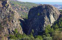 Ierapetra, Lassithi at 27.4km (S) A monument of natural beauty that attract a lot of local and foreign visitors. The gorge of Sarakina (GR: Σαρακίνα) is one of the most beautiful in Crete. Its steep, vertical walls in some parts reach a height up to 250 m. Its widest opening is no more than 15 metres while in some places it’s so narrow that its sides seem to join each other. Its rich flora and fauna, the dittany, the wild birds that nest there, the running water make the route through the gorge a worthwhile experience. 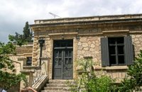 Knossos at 27.4km (S) Villa Ariadne was built at Knossos, Crete, by Sir Arthur Evans soon after he discovered the Minoan palace, when the site was his own private property. The villa became home, in turn, to John Pendlebury, who used it as a base for his excavations at Knossos and his explorations of the island. After Pendlebury's death at the hands of invading German paratroopers, the Villa Ariadne was taken over by General Karl Kreipe, who was living there when he was kidnapped by Patrick Leigh Fermor and his team. Ariadne villa is surrounded by the only existing Greek Edwardian garden, a large oasis of Cretan and other flora and shrubs in specific formations. The garden has been fully studied by the British School of Archaeology with the participation of special architects and agronomists from Heraklion. 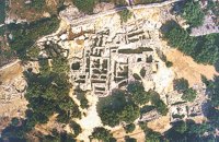 Archanes at 27.7km (W) Excavations at Phourni have brought to light 26 buildings, most of which had funerary use. The cemetery was used from 2400 B.C. until 1200 B.C. and each complex had more than one architectural phase. Most of the funerary buildings were used for many decades and contain successive burials. Excavations were begun in 1964 by Efi and John Sakellarakis and have been continued until today (1995) with short interruptions. Most of the buildings are preserved in good condition. 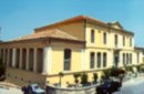 Archanes at 27.8km (W) An excellent specimen of a specialized building, one of the first structures erected during the period of the Cretan State. It was designed by the architect Salivero, one of Prince George's officials. The plans were completed in 1901 and the construction was accomplished thanks to donations of rich Archanians living in the U.S.A. The building is Pi-shaped in plan, has two storeys and a basement, it is built of stone and its roof is partially wooden and covered with tiles. It is a monumental but well balanced structure with many harmonic and elegant Neoclassical features. Since its construction, the building has been used as a school. During the German occupation it housed General Muller's division. Source: The Hellenic Ministry of Culture  Knossou Av. Iraklion at 27.9km (W) The General Hospital of Heraklion "Venizeleio & Pananio", named after the great statesman Eleftherios Venizelos, is one of the largest hospitals in Crete with 500 organic beds. It is located 4km away from Heraklion center on the road to Knossos, and occupies an area of 25,000 sq. meters. Venizeleio hospital provides high quality health services to citizens in a friendly and human environment. It was established in 1953 by a donation of Cretans of America and worked initially for Pulmonary Diseases. It was for many years the major hospital in East Crete. Telephone: (+30) 2813 408000 Website: www.venizeleio.gr/  Archane, Iraklion at 28km (W) The Archaeological Museum of Archanes opened in 1993. It occupies an area of 570 square meters and it is located at the Tzami quarter in the center of the settlement. There, for the first time in Crete, the archaeological finds from a single site are exhibited. While the exterior spaces of the building were adapted to a tasteful ensemble, in resemblance with the impressive modesty of the environment and the traditional ochre and rosy colour tonations of Archanes. The interior was thus arranged as to accommodate the most modern mode of exhibition, especially attractive for the visitor. 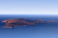 Iraklion north at 28.5km (NW) Dia (GR: Δία & Ντία) is an uninhabited island approximately 7 nautical miles north of Heraklion. It is surrounded by small rocky inlets and its maximum length is 5kms while its maximum width 3kms. Dia is one of NATURA's protected areas due to its status as a biotope for endemic plants and for plants with low dispersal within the Southern Aegean. Image Library
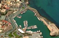
 Iraklion at 28.9km (W) Since 1985, with hard work, we have managed to become well known and trusted car hire company, not only in Crete but also amongst our numerous customers from Europe and other countries. We are the cheapest in town. We deliver to port, airport and hotels. Full insurance without excess. - New models, Safe Cars, Special Offers. No deposit required for booking. 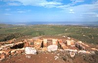 Archanes at 28.9km (W) Anemóspilia (GR: Aνεμόσπηλια). Anemospilia is an archeological site at the northern foot of Mount Yuchtas, in the prefecture of Heraklion in Crete. A rectangular building has been found which dates from the Minoan era and was destroyed by an earthquake in the 17th century BC. The building with three narrow chambers, each opening into a long corridor to the north, which extends along the whole width of the building. The area is enclosed with a stone wall and the whole structure has been interpreted as a shrine; in the central room was found a "xoanon" (statue) of the deity worshiped here. In the west room, where the altar stood, was uncovered, according to the excavator, the first human sacrifice to have ever taken place in Minoan times. (although this view has been challenged). The building at Anemospelia was used for only half a century, as it was suddenly destroyed by an earthquake in the middle of the 17th century B.C. The site was excavated in the summer of 1979 by John Sakellarakis.  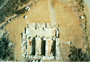 Aerial view 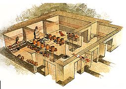 Shrine model Links: Minoan Religion (Foundation of the Hellenic World)  Ierapetra, Lassithi at 29km (S) Deep inside the valley of the river Sarantapihos is built the village Mythoi. It is 22 km away from Ierapetra, it is a small village, in a verdurous landscape,with a beautiful square under the shade of age-old planes. It is said that the village took its name from the plant “Minthi”, or mint, which is abundant there.However, it may have been named thus because of its many legends, traditions, and myths (mythoi), the most prevalent one being the Sarantapihos’ one. A mythical giant, forty ells tall, like another Talos or Akritas Digenis, he protected the residents from raids. There are the place names “Tou Sarantapihoui Patounia” (Sarantapihos’ footprint) and “Tou Sarantapihou to Mnima”(Sarantapihos’ grave). There is evidence of ancient habitation at the site “Leniko” where traces of walls can be seen. Also, in an excavation, the head of a woman of the Roman period has been found. At the sites Kastelou Haraki and Orfanou to Spiliari claypots, oil lamps, e.t.c. have been found. The site called Sarakina above Mythoi was a fortress, a hideout of Saracen pirates. The village’s modern history is rich in contributions to the struggles against the conquerors. It nurtured the chieftains Emmanouil Xenikakis, Ioannis Hatzakis, Emmanouil Christakis andothers. During the German Occupation, residents of Mythoi took part in the guerilla corpses of the United Resistance of Captain Bantouvas. In the battle of Symi, one of the most heroic figures was lost, Apostolos Vagionakis, who stood up to the enemy’s bullets for the ideals of our unsubdued Crete. They paid the price of their participation to the struggles during the German Occupation,as 4 persons were executed, including the old and bedridden Nikolaos Ioannou Christakis. The community of Mythoi is today a Local Department of the Municipality of Ierapetra, in 1900 it had 360 Christian residents, in 1951 it had 423 and in 2001it had 287. In the north of Mythoi, around 6 km away, there is the settlementKarydi with the famous Monastery of Panagia (Our Lady) Karydiani and now abandoned summer residences. The mountainous settlement “Minos”, which is situated in a verdurous small plateau below the Afentis peak of the Lasithi mountains, also belongs to the Community of Mythoi.The village Mythoi is a lively village with a rich social and cultural life. It has a cultural association, a football team and field, and a modern olive press. The village’s square with its old plane trees, the mulberry trees, the old fountain,the traditional coffee-houses with the raki and the local dishes, is a place of reference for the residents of Mythoi. The sights, the wild natural landscapes in the north of the village, the famous gorge of Sarakina, a monument of natural beauty, attract a lot of local and foreign visitors. The gorge of Sarakina is one of the most beautiful in Crete. Its steep, vertical sides cause awe, and reach a height of up to 250 m. Its widest opening is no more than 15 m while in some places it’s so narrow that its sides seem joined. Its rich flora and fauna, dittany,the wild birds that nest there and the route inside the gorge are breath-taking. Its promotion is a foremost goal of the Local Department and the Municipality of Ierapetra, of the residents of the village, who head to the future with optimism and anticipation for the development of their place. Source:The Municipality of Ierapetra. 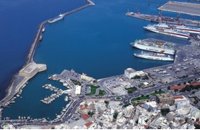 Iraklion at 29.2km (W) The Port of Heraklion is the main and most modern gateway for the transport of passengers and commodities on the island of Crete. There are three main companies that connect Iraklion to mainland Greece, Minoan Lines, Superfast Ferries and ANEK. During the winter months there are daily trips from Athens to Iraklion. The trip takes approximately 6 - 9 hours by ferry boat. The ships depart Athens in the evening (10.30 p.m.) and arrive in Iraklion at 5:00 - 6:00 a.m. There is also a weekly trip to Thessaloniki. During the summer season all companies operate also an extra daily trip that departs in the morning from Athens and arrives at Iraklion port in the afternoon. Finally various other companies operate ships connecting Iraklion with other island in the Aegean (Rodos, Santorini etc.). Daily cruises are also offered to the island of Santorini. Image Library
 North - Central Crete at 29.3km (W) Iraklion (Heraklion or Herakleion GR: Ηράκλειον) is the largest urban centre in Crete, the capital of the region and the economic centre of the island. The first European civilisation, the Minoan civilisation, flourished on this land 5000 years ago. Currently the population of Iraklion is approximately 150.000 people. It is a very dynamic and cosmopolitan town, particularly during the summer period when thousands of visitors can be seen shopping in the market or visiting the museums and other places of interest. Today Heraklion is the top choice for tourist destinations in the Mediterranean. The city is also the commercial and scientific centre of the island. During the last 20 years the city has made remarkable progress in the academic and technological fields...
Image Library
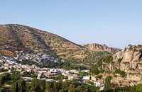 Ierapetra, Lassithi at 29.3km (SE) One of the most beautiful parts of the hinterland of Ierapetra is occupied by the picturesque village of Kalamafka. It is situated on the edge of the Lassithi mountains, an area known for its impressive diversity in landscape. Kalamafka sits at an altitude of 480 meters, 15 kilometers from the town of Ierapetra and 25 kilometers from Agios Nikolaos. Kalamafka is a picturesque, large, and prosperous village surrounded by unique natural beauty. The springs at Kefalovryso, with its plane trees and lush vegetation, as well as its old historical churches, gorges, and springs, attract visitors due to the oasis-like coolness it offers in this otherwise dry and hot region. The village's wealth lies in its water sources and the vitality of its residents, who resist urbanization. Another reason for Kalamafka's enduring population is its advantageous location, as it is centrally positioned between the north and south coasts of the island, drawing daily visitors from Ierapetra and Agios Nikolaos. History: The village derives its name from "Kali Afkla," a wooden channel that was once used to transfer water from one riverbank to another at the springs of Kefalovryso. Another explanation for the name is that the rock formation on Kastelos Hill resembles a Greek Orthodox priest's hat (kalymafki). Kalamafka, known as ancient Larisa, has been inhabited since the Minoan era. In the Psathi area, along the road to Ierapetra, archaeological findings such as human skulls, clay pots, spearheads, and various grave goods from the sub-Minoan era have been discovered. The geographer Strabo mentions Kalamafka, ancient Larisa, as follows: "And in Crete there is the city of Larisa, which now is united with Ierapytna, and from which the plain below, called Larision, takes its name." The god protector of ancient Larisa was Asclepius, and this is why the Medical Association of Lassithi has adopted the figure of a statuette discovered on the Kastelos peak, which overlooks the village and served as a peak sanctuary according to Mr. Michalis Pytikakis. Larisa was conquered around the 3rd century B.C. by Ierapytna, and its residents were relocated as per the terms of the treaty. Evidence from subsequent historical periods suggests that the Kalamafka area has been continuously inhabited due to the presence of the water sources of Kefalovryso. Place names like Kastelos, Mesokastela, and Larisakia attest to its historical significance. Kastelos Hill, serving as the seat of a feudal lord during the Venetian rule, had 435 residents in 1583. It boasted several notable Byzantine and post-Byzantine churches, along with numerous chapels. During the Turkish rule, it was a breeding ground for prominent chieftains like Nikolaos Foniadakis and Ioannis Baritakis. The village's history is marked by struggles and sacrifices that cannot be easily summarized. Today, Kalamafka is a vibrant village with a growing population. It has a two-seat school, a nursery school, a cultural association, numerous coffee houses, and seven taverns. The natural landscape, often referred to as "Chinese" due to its small rock pillars with bonsais, stone formations, and Kastelos Hill with its 224 steps, is considered a monument of natural history. Kalamafka offers visitors a wealth of attractions, including caves, rock paintings, the Havgas gorge, an ancient olive press, and the churches of Saint John and Saint Anthony. The taverns, shaded by plane trees and surrounded by running water, serve traditional and delicious local dishes, including the traditional "klostenios" halva and skyfomakarounes (local pasta). The sounds of the lyra, violin, and lute add to the ambiance, pleasing both locals and foreigners. There are indeed many compelling reasons to visit Kalamafka. By Toby Robert Image Library
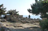 Archanes at 29.3km (W) The Minoan villa at Vathypetro was most likely the residence of a local ruler. Its architecture is comparable to that of a "Little Palace": it has a central and west court, a small tripartite shrine, a three-columned portico, storerooms and workshops. It seems that the construction of the building was never completed. Interesting elements of its architecture are the installations of a wine-press in the south wing and an oil-press in the courtyard. 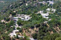 Ierapetra, Lassithi at 29.3km (S) A small village built at an altitude of 540 m in the south parts of the mountain Dikti at the borders of the province of Ierapetra-Viannos. The imposing mountains above the village, the south horizon among the olive-covered hills and in the lower villages, the cool climate create in you a sensation of bodily and spiritual well-being at this balcony of the Cretan nature. Five settlements, two of them uninhabited today, constituted the Community of Riza, now a Local Department of the Municipality of Ierapetra. 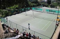 Iraklion at 29.9km (W) The Club was founded in 1928 by Stelios and Stefanos Perdikojiannis, Meletis Kokkinakis, and Nikos Pandelakis. Until 1940 it was operating as an independent part of the Union of Athletic Associations of Iraklion, having Mr George Voiolas as president. In 1946 it became an independent club under the name "Tennis Organization of Iraklion" , commonly "TENNIS", with department of tennis and table tennis. Later in 1968 two more departments were added, basketball and volleyball, and finally the department of chess in 1978. In 1975 the club was renamed to "Iraklion Sports Club". Today the most active departments are: Basketball, Tennis, Table tennis, Chess. Links: Official Site 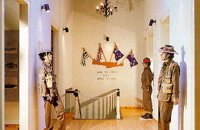 Heraklion at 29.9km (W) The Museum of the Battle of Crete and National Resistance (1941-1945) was founded by the Municipality of Heraklion in May 1994.The museum's aim is to collect, preserve and exhibit relics from 1941-1945 in an appropriate manner, as well as to document and disseminate information on the people's struggle during the Battle of Crete and the German-Italian occupation. In addition to presenting a range of material witnesses to the past, the museum aims to cultivate interest and respect for the history of Crete. Contact details: Doukos Beaufort and Merambellou Str. Tel. (+30)2810 246 554 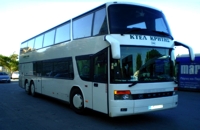 Heraklion Port at 29.9km (W) Crete Public Bus Services (KTEL) with modern air conditioned buses and experienced personnel, offer travelling people, secured, comfortable, quick & affordable transportation almost to the most remote spot of the island. The bus station at Iraklion is situated at the port only a few minutes walk from the town's center. Timetables : East Crete Timetables-KTEL Heraklio - Lassithi West Crete Timetables-KTEL Hania - Rethymnon 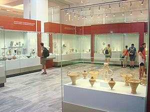 Heraklion city at 30km (W) The most magnificent collection of Minoan art and culture in the world, unique in beauty and completeness is housed in this museum. The exhibiton of the museum is organized in chronological order, ranging from the Neolithic period to the Roman era (4th century A.D.) and geographically, according to the provenance of the finds.
 Iraklion at 30km (W) The Emmetropia Mediterranean Lasik Eye Clinic, a private-sector ophthalmic surgery clinic, offers advanced vision correction in a patient-centered environment. Access to conventional and cutting-edge refractive surgery technologies such us Lasik, Lasek and more, for a wide range of vision problems, enable our physicians to optimize results by meeting each patient´s individual needs. |
||
|
| ||


C
O
N
T
E
N
T
S
O
N
T
E
N
T
S