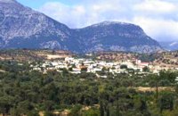
Zaros is a picturesque village located at the southern slope of the mountain IDI (Psiloritis) at 340m a.s.l, 45 km from Iraklion.
It has 2,241 permanent residents.
The main occupation of the inhabitants is farming and stock breeding, while there are quite a few traditional workshops of weaving, painting (icons), and musical instruments.
The name Zaros is considered to be prehellenic, and means the abundant water flow. It is clearly indicative of an age old history which is further verified by the Minoan findings in the Kourtes (Κούρτες) area, as well as the remnants of the Roman aqua ducts from which ancient Gortina got its water supply.
Access
There is regular bus transportation from Iraklion to Zaros. There is also daily bus schedules from/to Mires and Kamares.
You can also rent a car from Iraklion and take the road Iraklion -Mires- Festos. The crossroad from the village of Agia Varvara leads to Gergeri, Nivritos and after 16km to Zaros.
Facilities
There is a police station, post office, doctor's office, and pharmacy.
The visitor can find a hotel with all facilities, and many smaller ones in traditional style.
There are also taverns with cretan specialties and fresh salmon or trout from the local fish ponds.
Many cafes, bakery and grocery shops and Taxi station.
Worth seeing & Excursions
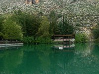
The visitor to Zaros has the opportunity to admire the wonderful mountainous landscape, the numerous monasteries and churches of the area, the traditional architectural style of the old houses, the small lake of Votomos, and experience the day to day life of local people.
With Zaros as a starting point, one can easily access most of the archaeological sites of Iraklion, and of course the gorgeous beaches of southern Crete.
Zaros is also the ideal place for those who love trekking, hiking and climbing, as the European Climbing route E4 crosses the village.
- The traditional neighbourhoods the worksops, the houses of the village, and the traditional productive activities.
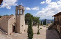
- The churches of Panagia, Agios Georgios, and Agia Kiriaki with the exquisite Templo wood carving and fascinating icons dating back to the previoius century.
- The traditional watermills one of which (in the area of Votomos) has been in working order since the 16 th century.
- The deserted settlements of Fari and Kourtes, south of Zaros, surrounded by beautyful landscape.
- The lake at the area of Votomos. A small man made lake, not far from the village, ideal for walking and pic-nic.
- From the springs of Votomos the ancient city Gortina got its water suply.
- Today a municipal enterprise, is bottling this water and sells it to the Cretan market and abroad, under the name "ZAROS".
- The Vrontissi monastery with the excuisite marble fountain and frescoes of the once renowned Cretan Fine Arts School. (Dradition says that Dominikos Theotokopoulos "EL GRECO" studied at this school)
- The now decrepit monastery of Varsamonero, with the temple of Agios Fanourios decorated with 15th century frescoes.
- The chapel of Agios Efthimios and the monastery of Agios Nikolaos, at the mouth of the gorge of Agios Nikolaos.
This gorge provides great climbing trails. The E4 European Climbing Route crosses the village and the gorge.
- Moreover the massifs of the greater region are lined with hiking trails of national interest which can be crossed with Zaros as starting point.
- The gorges of Kamares and Voriza, the renowned Rouva forest as well as the forests on the slopes of Samari on Psiloritis and the Nida plateau are some of the better known areas of mountain IDI which was considered to be sacred by the ancient Greek people.