The ancient settlement of Vasilike is one of the first Minoan settlements with town-planning. It occupies the top and slopes of a low hill near the village Vasilike, in the vicinity of the Minoan settlement of Gournia. The first settlement dates back to the Early Minoan II period (2600-2300 B.C.) and owed its development not only to the strategic position, controlling the Isthmus of Hierapetra, but also to the neighbouring fertile plains. The central building of the settlement was destroyed by fire in around 2300 B.C.
The hill was again occupied in the Middle Minoan period as attested by a building of the period (2200-1900 B.C.), while scant traces of habitation date to the Roman period.
The first excavation of the site was conducted by American archaeologists, first H. Boyd and later R.B. Seager, in the beginning of the 1900s. In 1970, the systematic excavation of the site was begun by A. Zois, under the auspices of the Athens Archaeological Society and is still in progress. The old excavation trenches were cleared and stratigraphically investigated.
The most important monuments of the site are:
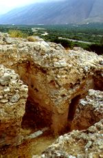
The "House on the Hilltop". A large building, which can be considered a forerunner (on a small scale, however) of the later Minoan palaces. Its orientation, with the corners pointing to the cordial points is possibly influenced by Oriental architecture. The rooms are rectangular, connected with long corridors. The south wing is the largest. Some of the oblong rooms can be considered magazines, others are personal quarters; the building includes a paved courtyard with a rock-cut well or light-well.
The interior surface of the walls was covered with red plaster, while the walls were reinforced with timber frame. The walls of the ground floor are built of small stones, bounded with clay and straw, while those of the upper storey were made of mud bricks.
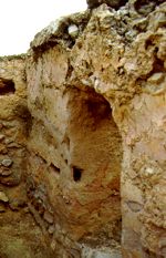
House A. It is a typical example of the Middle Minoan "agglutinative" architecture, with rooms added when needed; the plan of the houses, however, had a certain regularity. It is located at the junction of two streets and has a narrow doorway entered from the stepped street. It seems that the settlement had four main building phases, each represented by remains of houses . Especially in the Middle Minoan period, the houses must have extended to the whole of the east side of the hill.
Source:
The Hellenic Ministry of Culture