interkriti®
YOUR GATEWAY TO CRETE
HOME
CRETE FACTS
NAVIGATE
EXPLORE

Agia Galini
Triopetra
Kissamos
Chryssi Isl.
Agia Marina
Balos
Gavdos isl.
Georgioupolis
SAMARIA
IDA Mtn
Palaiochora
Agia Roumeli
Sfakaki
Bali
Kalamaki
Matala
Lassithi
Plateau Lendas
Tsoutsouros
Vianos
Myrtos
Sfakia
Plakias
Ierapetra
Makrygialos
ZAKROS
Vai
Sitia
Agios Nikolaos
Elounda
MALIA
Hersonissos
Gouves
Chania
Rethymnon
Heraklion
GORTYN
FESTOS
KNOSSOS
|
|
Crete
List Grid Map
Found
262
- Showing :
241 - 260
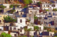 Ierapetra, Lassithi at 44.5km (SE) The village of the rising sun, as its name declares. The golden rays illuminate Anatoli, the hanging rocks, the Holy Cross church, Drygies, Karkasa, and give the impression that the sun keeps rising. It is an old, historical, traditional village, situated at 17 km in the north-west of Ierapetra, at an altitude of 600 m. Its housesare visible from the plain and seem like white doves, nested in the fortified mountain of Anatoli. A privileged place, it has been a cradle of men of letters, Notaries, University professors, with great history and civilization.In the 70s, most of Anatoli’s residents got down to the plain and worked in the glasshouse cultivations. They founded, along with residents from other villages the settlementsStomio, Nea Anatoli, Ammoudares. The small picturesque village Kalogeroi, which, according to tradition, was built by a Turkish Aga, is part of Anatoli. It is referenced sincethe era of the Venetian rule. In 1583, along with Kalogeroi, it had 666 residents. In 1951 it had 897 and in 2001, along with Nea Anatoli, it had 1235 residents. The Tower of theVenetian feudal lord still lies in ruins in the north of the village. It nurtured important men of letters, such as Antonios Damilas, scribe and printer, Neilos Damilas, scholarlypriest-monk in the Karkasia Monastery, Dimitrios Damilas, brother of Antonios, scribe and printer in Milan, who published the “Greek Grammar” in 1476, Anthimos Donos,and Ioannis Olokalos, whose notary documents have been recently published. The latter had his seat in Drygies, a wonderful location in the east of the village with runningwaters, a tavern with a view of Ierapetra and the little church of Saint Foteini. Anatoli was an important intellectual center, having a school during the Venetian rule and a secretschool during the Turkish rule.The area of Anatoli, a fortified position, produced great fighters during the Turkish rule, such as Emmanuel Lakerdas, general chief of Ierapetra, Iakovos Mahairas, AthanasiosBarberakis and Georgios Bekiaris.Its history and struggles were imortant in all the historical periods. It has many ecclesiastical monuments, Monasteries and Byzantine icons of great art.The old traditional settlement of Anatoli has remained untouched by time, with its stone-built houses, the alleys, the old Kato Vrysi. Five years ago, it entered a program ofrenovation, was characterized as a traditional settlement and today houses and tourist lodgings of exceptional esthetics are built in stone. In a few years, Anatoli of Ierapetra willbe one of the most beautiful villages of Crete, with its wonderful climate, its extraordinary view, its incomparable natural landscape on which the Museum of Natural Historyof Crete has worked and about which it published a relevant document.Anatoli as well as its residents have to this day been successful in the agricultural, tourist and intellectual sectors. Personalities coming from the village dominate the political,social and intellectual life of our country. Anatoli was a Municipality in the beginning of the 20th century, then a Community and today a Local Department ofthe Municipality of Ierapetra, building its future on solid foundations. Hosting important cultural events, with itshistorical, folkloric and musical contributions, it is a center of attraction of bothlocals and foreigners. With two taverns, two coffee houses, a renovatedold school and hospitable residents, it satisfies the most demandingvisitors. Anatoli is even rich in snails and wild mushrooms.
 Messara, Iraklion South at 45.8km (SW) The village of Pitsidia is located 65 km southwest of Iraklion at an altitude of 80 m a.s.l, just before the magnificent bay of Messara. The village with aproximately 700 inhabitants is the oldest village of the area and is refered (by S. Spanakis) that it was the place where the soldiers of Nikiforos Fokas, commander of the Byzantine army, settled. The army, famous for its bravery, came from Pisidia of the south Asia Minor, and this is probably the origin of the name Pitsidia.
Image Library
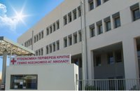 Agios Nikolaos, Lassithi at 45.9km (E) Agios Nikolaos General Hospital (GR: Γενικό Νοσοκομείο Αγίου Νικολάου) is located in Agios Nikolaos in the prefecture of Lassithi. The St. Nicholas Hospital is a large modern hospital that provides full medical treatment and services to the population of the area since 1940. 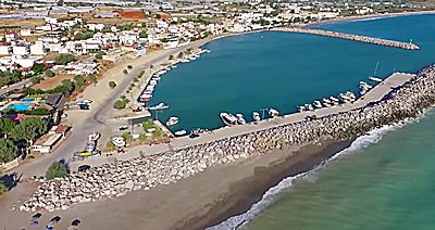 Messara bay, Iraklion South at 46.1km (W) Kokkinos Pirgos (GR: Κόκκινος Πύργος) is a small coastal community, 2km away from Timbaki with a nice, long sandy beach, one of the longest in Crete, and a clear transparent sea. The part of the beach to the north west of the harbour is called Makrimaliana (or Kakoskalo) and the south east part of it is called Katalyki . The harbour in front of the village of Kokkinos Pirgos, offers docking facilities for sailing and fishing boats. There are hotels, restaurants, bars, etc. across the harbour and along the beach. You can always find good fresh fish in the taverns of the village. Kokkinos Pirgos (meaning red tower) , took its name from a castle that use to be there during the Middle Ages, which was built by red clay earth.
Image Library
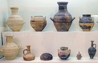 Agios Nikolaos, Lassithi at 46.1km (E) The Archaeological Museum of Aghios Nikolaos is one of the most important in Crete and has been in operation since 1969. It houses collections of very important archaeological finds from the whole of Eastern Crete, an area extending from Malia as far as Zakros. These are displayed in chronological order from the Neolithic period (5700 - 2800 B.C.) to the end of the Roman times (100 B.C. - 400 A.D.) Its showcases include more than 1350 vases from the 3rd millennium B.C. as well as gold and copper finds (the most ancient found in Crete).
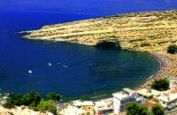
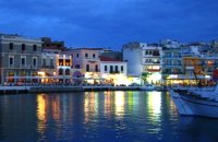 Agios Nikolaos, Lassithi at 46.4km (E) Lake Voulismeni (Gr: Λίμνη Βουλισμένη) or just "the Lake" for the locals, is located at the centre of the town of Agios Nikolaos. It has a circular shape of a diameter of 137 m and depth 64 m. The lake connects to the harbour of the town by a channel dug in 1870. A panoramic view of the lake can be seen from a small park situated above it. According to legend, the goddess Athena bathed in it. Every year at midnight turning to Orthodox Christian Easter day, the majority of the population of the town gathers around the lake to celebrate with fireworks, and firecrackers. It was reported that the German army during their withdrawal from the area at WW2, disposed parts of their weaponry and/or vehicles into the deep lake. A local urban legend has it that the lake is bottomless. That notion is potentially based on its impressively disproportional high depth compared to its width (64m depth on only 134m width) or/and on locals noticing disturbances at the surface or also the level of the water during the Santorini (Thera) earthquake of 1956. Because of the latter, many assume a possible geological relation of the two locations, but this claim has not been substantiated by known scientific surveys to date. Image Library
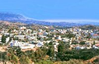
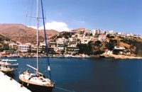
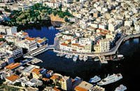 North East Crete, Lassithi at 46.5km (E) Agios Nikólaos (GR: Αγιος Νικόλαος), with 9.500 inhabitants, is the capital of the Lassithi province of Crete. It is built around a picturesque lake at the north-western side of the Mirabello bay, the biggest bay in Crete. Major administrative, cultural and communications center, Agios Nikolaos is one of the most developed tourist areas, not only in Crete but in Greece in general. Thanks to the beautiful coasts, the great sights and the cosmopolitan life, this lively city hosts every year thousands of visitors without losing one bit of its tranquility and traditional hospitality.
Image Library
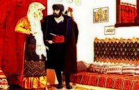 Agios Nikolaos, Lassithi at 46.5km (E) The Folk Art Museum of Aghios Nikolaos, in collaboration with the "Cultural Society of Eastern Crete", founded in 1978. All the original and important material was generously offered by the Touring Club of Aghios Nikolaos. Since then more objects have been added to the collection. A visit to the Folk Art Museum will help you to become familiar with the sort of work and activities the people of this area had in the old days. The Museum houses a rich and beautiful collection of hundreds of genuine samples of Cretan popular art and mainly hand woven and embroidered pieces, some of which are unique. 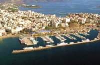 Agios Nikolaos, Lassithi at 46.5km (E) Well protected Marina by all weather condition, build to European standards and capable to accommodating up to 255 boats all year round. The Marina of Aghios Nikolaos is located in the heart of the town, provides all the necessary facilities for a pleasant short or long stay for yacht passengers and a safe environment for the boats. Facilities: Water/Electricity:Each berth has access to a service box where fresh water and 220 / 380 volt electricity available. 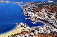 Mirabello Bay, Lassithi at 46.7km (E) The area is touristic developed with many shops, restaurants on the shore, bars and several excellent hotels famous for their comforts and the variety of amenities offered. The lagoon of Elounda is shaped between the coast and a small peninsula of 7-8 km length ... Spinalonga, since antiquity, has protected the harbor of ancient Olous.
 Messara bay, Iraklion South at 46.9km (SW) A small coastal village with a long sandy beach is becoming very popular with tourists due both its natural beauty and its proximity to Phaistos, Gortys and other important sites. There are quite few hotels, apartments etc and taverns, cafes by the beach.
 Messara plain, South - East Iraklion at 47.2km (SW) The monastery of Odigitria is a monastery of great importance and historical value and one of the oldest in Crete. It is located at the west edge of the Asterousia mountains at an altitude of 250 m. The monastery was surrounded by walls, part of them still stands. The temple of the monastery is dedicated to the assumption of Holly-Mother and to the Saint Apostles (Peter & Paul). Inside the temple there are valuable frescoes, icons of famous painters and iconostasis. The monastery is connected with the legendary freedom fighter 'Ksopateras' (1788 - 1828) In the area of the monastery at Agioi Eftihianoi was found an ancient (Early Minoan) cemetery. 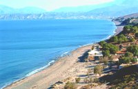 Messara Bay, Iraklion at 47.7km (SW) One of the most beautiful sandy beaches of Crete, extends from a clump of rocks riveted in the shallow waters in the south to the Kalamaki settlement in the North. In Minoan times there used to be the ancient port of Phaistos. The antiquities lie just a few meters away from the sea.
Image Library
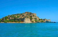 Elounda, Mirabello bay, Lassithi at 48.4km (E) The island of Spinalonga (Gr: Σπιναλόγκα), officially known as Kalydon (Καλυδών), is located in the Gulf of Elounda in north-eastern Crete, in Lasithi prefecture, next to the town of Elounda. The official Greek name of the island today is Kalydon. Originally, Spinalonga was not an island, it was part of the island of Crete. During Venetian occupation the island was carved out of the coast for defense purposes and a fort was built there. A popular name for the island since Venetian rule is Spinalonga. During Venetian rule, salt was harvested from salt pans around the island. The island has also been used as a leper colony. Spinalonga has appeared in novels, television series, and a short film.
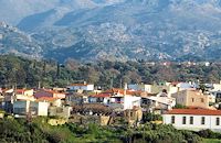 Mylopotamos, Rethymno at 48.7km (W) Margarites (GR: Μαργαρίτες) with 300 inhabitants, is located 27 kilometers from Rethymnon at 300 m above sea level near the amcient town of Eleftherna. Margarites, is a village with Venetian roots, mentioned by sixteenth-century travellers. In the nineteenth century, Margarites was a flourishing town, whose centuries-old ceramic tradition began at least as early as the Ottoman period. Margarites is undoubtedly the most important pottery centre in western Crete. 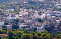 Ierapetra, Lassithi at 48.7km (E) Between OLEROS and OLERIA there is the village Meseleroi, which took its name from the ancient OLEROS. It is situated at 10 km in the north of Ierapetra at an altitude of 360 m. Ancient Oleros flourished during the classical times, to be conquered by thepowerful Ierapytna. Oleria was a place of worship for Oleria Athena, with its famous statue, venerated by the residents of Oleria and Ierapytna. Monastiraki (The archaeological site) Amari at 48.8km (W) Monastiraki lies in the valley of Amari, on the natural route leading from northern Crete to the Messara plain. Excavations have brought to light a centre of the Old Palace period (1950-1700 B.C.). which was destroyed by fire following an earthquake. The large number of storerooms and the existence of two archive rooms with many clay sealings indicate a palatial character for the site. Other finds on the top of a neighbouring hill suggest there must have been a religious centre in the area, as well. Image Library
 Messara, South - West Iraklion at 49.6km (SW) Matala (GR: Μάταλα) was the ancient port of Phaistos and Gortys and a former fishing community which has developed into a modern holiday center. It is located 4 km south-west of the village of Pitsidia and 75 km from Iraklion. It is built on the coast line of the Messara bay inside a small and picturesque inlet. During the 60's the caves of Matala were hosting a hippie commune.
 South Rethymnon at 49.7km (W) A seaside town of the municipality of Agios Vassilios. It is a well organized tourist resort with comfortable hotels, apartments, camping sites, tourist agencies, car-renting offices, restaurants, tavernas and other recreation centres, as well as all the facilities required by tourists and locals alike. There is also a port and port - custom authorities.
Image Library
 Mylopotamos, Rethymno at 49.7km (W) Eleftherna (Eleutherna GR: Ελεύθερνα) is located on the foothills of Mount Psiloritis, in the heartland of Crete, 25 km. southeastern of Rethymnon. It was inhabited continuously from the Sub-Neolithic period (4th millennium BC) down to the 12th cent. AD and its rich history is now summarized by five hundred selected artifacts unearthed from houses, shrines, public buildings and tombs.
|
||
|
| ||


C
O
N
T
E
N
T
S
O
N
T
E
N
T
S