interkriti®
YOUR GATEWAY TO CRETE
HOME
CRETE FACTS
NAVIGATE
EXPLORE

Agia Galini
Triopetra
Kissamos
Chryssi Isl.
Agia Marina
Balos
Gavdos isl.
Georgioupolis
SAMARIA
IDA Mtn
Palaiochora
Agia Roumeli
Sfakaki
Bali
Kalamaki
Matala
Lassithi
Plateau Lendas
Tsoutsouros
Vianos
Myrtos
Sfakia
Plakias
Ierapetra
Makrygialos
ZAKROS
Vai
Sitia
Agios Nikolaos
Elounda
MALIA
Hersonissos
Gouves
Chania
Rethymnon
Heraklion
GORTYN
FESTOS
KNOSSOS
|
|
Crete
List Grid Map
Found
206
- Showing :
61 - 80
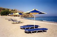
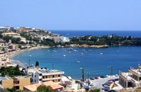
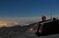 Idi mountain at 33.1km (SE) Located at the top (1750m) of Skinakas mountain of Idi (Ida) mounatin range, 60km from Heraklion. There are two telescopes and modern equipment and facilities both for research and educational activities in astronomy. It is a department of the University of Crete. Skinakas observatory offers a number of open days each year. This gives the opportunity to visitors to be introduced to the operation of the observatory, to get informed about the latest achievements in Astrophysics and to observe through the telescope. Open days for the year 2012: August 26 September 23 During the open days the Observatory facilities can be visited from 17:00 to 23:00. Due to low temperatures at the Skinakas altitude, warm clothes are highly recommended. The visitors will have the opportunity to be guided through the Observatory's infrastructure and follow a related presentation. The road to Skinakas Observatory is very narrow. Accident may occur and the space is limited on the top. For the reasons above, buses are not allowed (advised) to visit the Observatory during open days. Website : http://skinakas.physics.uoc.gr/ 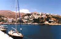 South Rethymnon at 33.3km (S) A seaside town of the municipality of Agios Vassilios. It is a well organized tourist resort with comfortable hotels, apartments, camping sites, tourist agencies, car-renting offices, restaurants, tavernas and other recreation centres, as well as all the facilities required by tourists and locals alike. There is also a port and port - custom authorities.
Image Library
 Malevizi, Iraklion at 33.6km (E) Dóxa (GR: Δόξα) is a pretty village built on a height of 400 metres above sea-level and 20 kilometres to the west of Heraklion on the road to the mountainous Milopotamos. The historical cave of Dóxa (GR: Δόξα) is located in a short distance from the village of Marathos on the road to Heraklion. It is at a height of 490 metres above sea-level, near a well-known taverna also called DOXA. The cave has a total length of 50 metres and impressive stalactites and stalagmites.  Rethymno south at 33.8km (SW) Two small villages, Epano & Kato (Upper & Lower) Rodakino halfway from Plakias to Frangokastelo, overlooking the bay of Korakas. Rodakino is 42 kms from Rethimnon, 27 kms from Hora Sfakion and 13 kms from Fragokastello. Rodakino is surrounded by small beaches some of them accessible only by foot, were visitors can isolate themselves from any trace of civilization. There are some small hotels and rooms to rent available and a couple of tavernas. The road to Rodakino is asphalt paved and there is a bus service to Rodakino from Rethimnon twice a day. In the village the visitor can find a taxi station, and a gasoline station. A doctor is available for medical emergencies on the village of Plakias approximately 15 kms from Rodakino. Rodakino played its own part during the eons, in the fighting of the Cretans against all the invaders. The village was totally destroyed during the Venetian occupation, with only one resident escaping to Peloponnese in Greece . Years after the destruction he returned to the site of the village, and he rebuilt it. In Kourkoylo one of the quarters of the village the first rising of the flag of the revolution against the Turks was raised on May 24th 1821. During the second World War the kidnapped German general Craipe was sent away from the bay of Korakas to the Middle East. Image Library
 Rodakino, South Rethymno at 34.6km (SW) At the end of the canyon that traverses the area of Rodakino lies the beach of Korakas at the bay of the same name. It is a nice, wide and 400m long beach, with clear waters and small grayish sand and pebbles. There are a few accommodation options in family run apartment complexes and a few taverns on the beach front. Umbrellas and sun beds are also available at the eastern part. The headland to the east separate Korakas Beach from another lovely beach named "Klimata". At the east side of that headland there is a small fishing harbour and along its coast there are sharp rocks in the shape of a crow's beak (Kórakas GR: Κόρακας, means crow) thus giving the name to the bay. Image Library
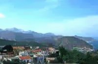 Malevizi, North - West Iraklion at 35km (E) Ahláda (GR: Αχλάδα) is a small village located 24 kms west of Iraklion at an altitude of 300 meters a.s.l. It is close to the tourist resorts of Agia Pelagia and Ligaria, and it has approximately 500 inhabitants, most of them farmers and stock breeders. The name of the village meaning wild pear tree is given probably due to the huge wild pear tree that used to be at the village. 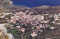 Apokoronas, Hania at 35.1km (W) Kókino Horio (GR: Κόκκινο Χωρίο), which is located at a higher altitude, has maintained its traditional architectural style even more so than the other villages with its narrow roads, beautiful gates and tiled roofs. A group of cisterns, built in a sloping field, gather the rainwater, an interesting example of local architecture, dealing with the permanent problem of lack of water. Above Kokino Horio one can see the strangely shaped hill Drapanokefala or Calapodha (so named during the venetian occupation). The coastline northwest of the village is an extremely interesting place for a stroll due to the ground formation and the caves, such as the cave of Petsi (or Karavotopos). Another cave called Katalimata, located at the centre of the village, is also an interesting site. At cape Drapano, approximately 10 metres under water, is the impressive Elephant cave, an area 60mx60m full of stalactites and stalagmites of various shapes and colours. Video - The Elephants' Cave  Sfakia, South Hania at 35.3km (SW) Kalikratis is a small mountainous village at the foot of the White Mountains (Lefka Ori) at an altitude of 750m above sea level. It is a traditional village with many well preserved stone houses. A German army of two thousand soldiers, invaded the village during the October of 1943 , burned it down and executed twenty men and nine women who did not manage to leave on time. A little to the south of the village starts the gorge of the same name which is part of the European hiking footpath (E4) and after some 4km walking ends at the village of Patsianos. 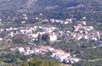 Apokoronas, Hania at 35.9km (W) Gavalohóri (GR: Γαβαλοχώρι) is an old big traditional village, with fine examples of traditional rural architecture and stone buildings that are well preserved. The village has been declared a traditional settlement and is awarded a protected status. Many interesting buildings still stand, such as the 18th century olive press, the church of Panagia (Virgin Mary) and that of Agios Sergios, the old school and the complex of the wells from the period of the Venetian occupation.
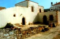 Gavalohori, Vamos, Apokoronas at 36km (W) The exhibition of the objects takes place according to the contemporary museum conception, with explanatory texts, photographs, plans, models, and is enriched with new exhibits every year. The Museum is divided into seven rooms, according to the following units: The Arched House, Silk, Pottery, Lace-making, Masonry and Stone carving, Church and Woodcarving.
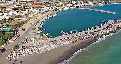 Messara bay, Iraklion South at 36km (S) Kokkinos Pirgos (GR: Κόκκινος Πύργος) is a small coastal community, 2km away from Timbaki with a nice, long sandy beach, one of the longest in Crete, and a clear transparent sea. The part of the beach to the north west of the harbour is called Makrimaliana (or Kakoskalo) and the south east part of it is called Katalyki . The harbour in front of the village of Kokkinos Pirgos, offers docking facilities for sailing and fishing boats. There are hotels, restaurants, bars, etc. across the harbour and along the beach. You can always find good fresh fish in the taverns of the village. Kokkinos Pirgos (meaning red tower) , took its name from a castle that use to be there during the Middle Ages, which was built by red clay earth.
Image Library
 Voriza, South - West Iraklion at 36.3km (SE) Close historical bonds link this monastery to that of Vrontisiou. The Varsamonerou Monastery lies in the surrounding fields of the village Voriza, 54.5 kms from Heraklion. The monastery is abandoned and, though its cells have been destroyed, its church has some of the most remarkable wall paintings in Crete.
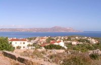 Apokoronas, Hania at 36.3km (W) Pláka (GR: Πλάκα) is a lovely village in the Apokoronas area, less than one kilometer away from Almyrida, with interesting architectural style, which is unfortunately changing due to intense building mainly for tourist purposes. Its ~300 permanent inhabitants, occupying mostly with farming, stock-breeding, fishing and lately with tourism. It has all the basic amenities, including excellent tavernas, bars, a grocery store and a kafeneion. Plaka is built on the slope of a hill at 70 m above sea, with a panoramic view of the bay of Souda. The surrounding environment has maintained its character well and is ideal for walks either inland or along the coast. Visitors can also admire a magical sunset from here. Every summer -at about the end of July- a two days traditional feast - The Plakiana - is organized to honour the memory of the great local lyra player Mihalis Papadakis or else Plakianos. During the feast guests enjoy Cretan dances and can visit the textile and ceramics exhibitions. The custom of Klidonas is celebrated at the end of June and the Carnival usually takes place in March. 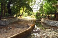 Apokoronas, Hania at 36.6km (W) The traditional little village of Vrisses lies approx. 35 km from Chania town. The old village square with its tall plane trees, the tavernas and kafenions is the perfect place to relax and enjoy the lush green landscape by the river Vrissanos and taste the renowned and particularly delicious local yogurt.
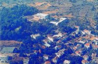 Apokoronas, Hania at 36.7km (W) Vámos (GR: Βάμος) is the capital of Apokoronas district is an exceptionally interesting village that the Ministry for the Environment, Physical Planning and Public Works has classed as traditional. It is more like a small town, very well preserved, with folk and neoclassical architectural elements. The initiative of a group of inhabitants to create an association for the preservation of the village as well as alternative tourism strategies is already paying off while constituting a model for further local progress. The famous art and cultural festivals are good opportunities for everyone to experience the hospitality and entertainment Vamos can offer.
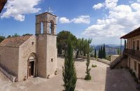 Zaros at 37.1km (SE) This is one of Crete's most famous monasteries. It played an important role during the years of the Cretan Renaissance, both in the letters and the arts, and, during the last centuries of Venetian rule, it was known for its many scholars, artists and venerable monks.
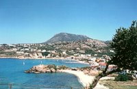 Apokoronas at 37.2km (W) A beautiful small sea side village with long sandy beach where wind surf, canoes, paddle boats, umbrellas and sun beds can be rented. The place provides all the facilities for the visitors with small hotels, rooms, apartments and many taverns with traditional food and fresh fish. Recent years it became very popular with expatriates and there is a significant development in the real estate sector.
Image Library
 Malevizi, North - West Iraklion at 37.4km (E) Agia Pelagia lies 20km west of Iraklion. The bay of Agia Pelagia is ideal for combining sea sports with relaxation. The visitor will find well trained instructors that offer lessons for sea sports such as water-ski, wind surf, canoe. Agia Pelagia offers unique high standard hotel facilities as well as many small hotels and pensions.
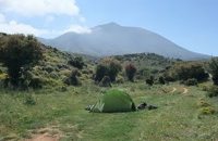 by Richard Ellis at 37.6km (SE) 11th, 12th and 13th June- We had made camp in the yard beside the Aghios Ioannis chapel at Rouvas but, the following morning, it was quite clear that I wasn’t going to go any further on foot until the shin splint had settled down a bit. Minor surgery on the blisters exposed the full extent of those problems and I hung them out to dry in the sun while Triantafyllos went off looking for paths to put on his maps. I think I was lucky not to get infected blisters but Betadine is a great resource which I used extensively.
 by Richard Ellis at 37.6km (SE) 14th June- The walk up from Rouvas is quite straightforward; once you have walked back down the stream from the Rouvas picnic area and turned right (north) up the dry river bed for two hundred yards, you scramble up a short, easy rock section (well sign posted) before the path continues up through open oak woodland (the Rouvas Forest) heading first for the Duo Prinoi chapel, which has a water tap, and then later up and over a ridge, beyond which a small dry water course leads up a steep sided valley to the flat lands of the Nidha plateau. Distance:12 km Time: 4.75 hrs. Mov av 3.7 km/hr Height overnight: 1,360m. |
||
|
| ||


;)
;)
;)
C
O
N
T
E
N
T
S
O
N
T
E
N
T
S