interkriti®
YOUR GATEWAY TO CRETE
HOME
CRETE FACTS
NAVIGATE
EXPLORE

Agia Galini
Triopetra
Kissamos
Chryssi Isl.
Agia Marina
Balos
Gavdos isl.
Georgioupolis
SAMARIA
IDA Mtn
Palaiochora
Agia Roumeli
Sfakaki
Bali
Kalamaki
Matala
Lassithi
Plateau Lendas
Tsoutsouros
Vianos
Myrtos
Sfakia
Plakias
Ierapetra
Makrygialos
ZAKROS
Vai
Sitia
Agios Nikolaos
Elounda
MALIA
Hersonissos
Gouves
Chania
Rethymnon
Heraklion
GORTYN
FESTOS
KNOSSOS
|
|
Crete
List Grid Map
Found
206
- Showing :
121 - 140
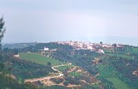 Malevizi, Iraklion at 42.2km (E) Petrokéfalo (GR: Πετροκέφαλο) lies 16km from Iraklion and 3km from Agios Myron at 340m a.s.l with 248 inhabitants. It is built on a rocky hillside. The hill' shape resembles to a human head and it is supposed that the village owes its name to this (petrokefali = stone head) . The settlement was fortified and lately were discovered significant ancient findings. The patron Saint is "Agia Paraskevi" and there is a village feast on the 8th September in her honour.
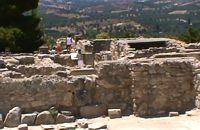 Phaistos Palace at 42.2km (SE) Almost the whole south part of the West Wing was dedicated to the shrines of the New Palace. The main architectural types of shrine are the "Bench Shrine" and the "Lustral Basin". The first type consists of small, rectangular rooms with low benches running round the walls, perhaps to support cult objects and figurines of the deity. On some of them were found female figurines, ritual vessels and "Offering Tables" (small altars). On the walls of some rooms are incised sacred symbols, such as the double Axe and the star. The "lustral Basin" type consists of rooms which are set somewhat lower than the surrounding structures, with a few steps leading down into them. The were usually lined with slabs of gypsum, giving them a highly - finished appearance. Although it is doubtful that these structures contained water, it is thought that they were used for purification rituals. There is a third type of Minoan shrine in the S-E part of the shrine wing. Its is a room with central pillars (Square, stone - built columns) thought to be a cult area, similar to the "Pillar Crypts" of the Palace of Knossos, where the sacred pillar was worshiped by pouring libations. 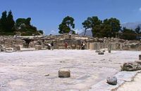 Phaistos Palace at 42.2km (SE) The great Central Court is a basic architectural element of Minoan palaces and the core around which the different wings are set. It was the focus of the economic, social and religious activity of the palace, the setting for events which could be watched from the windows and balconies. The Central Court of the Palace of Phaistos was built in the time of the Old Palace (1900-1700 BC). It was also used in the New Palace with minor alterations to its orientation and dimensions. It is a rectangular paved, open area with colonnades running along both its long sides, with alternating pillars and columns which supported open colonnades.On the west side of the court, two adjoining rectangular rooms with benches, open on to the Central Court, may have been "sitting rooms" for the spectators watching the events taking place in the Central Court. In the east colonnade of the court, some stone-built benches next to a water cistern may have formed islands of rest and recreation. The stepped structure in the NW corner of the court may have been an altar for the ceremonies which were held here. The pithoi (large storage jars) in front of it were found in buildings founded in the site of the Great Court after the destruction of the Palace. Image Library
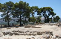 Phaistos Palace at 42.2km (SE) The east part of the North Wing forms the workshop area of the Palace. It consists of the East Court and a complex of small rooms which are believed to be the workshops of the New Palace (1700-1450 BC). Approximately in the centre of the court are the ruins of a horseshoe-shaped kiln. The elongated rectangular building with 6 rooms on the west side of the court appears to have been used for the workshops of the kiln craftsmen. The square room on the north side of the court was the gatehouse of the northeast entrance to the Palace. It has gypsum slab flooring and benches around the walls. Behind it is a long corridor leading to the inner courtyard of the North Wing and thence to the "Royal Apartments" Image Library
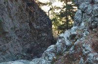 Sfakia, South Hania at 42.3km (W) The ravine begins from the last houses of the village of Imbros and 8 km after it ends at the village of Komitades. Its crossing is smooth and entails no danger...
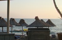 Messara bay, Iraklion South at 42.5km (S) A small coastal village with a long sandy beach is becoming very popular with tourists due both its natural beauty and its proximity to Phaistos, Gortys and other important sites. There are quite few hotels, apartments etc and taverns, cafes by the beach.
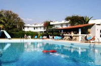 Ammoudara Beach, Iraklion at 42.6km (E) Gorgona is a family run hotel that offer all the modern amenities. It has its own swimming pool, and is surrounded by its own gardens with lush tropical vegetation, that spread on 5000 sq. meters. There is also a lounge with TV, bar, restaurant, reception, pool bar and a large private parking area. The 39 rooms have their own balconies, private bath, central heating, air conditioning, TV, radio, refrigerator, telephone and safe box. Sandy beach is only 200m away. Open all year round
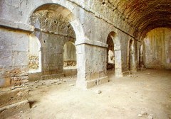
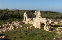 Aptera, Apokoronas, Hania at 42.7km (W) One of the most important city - states of Crete. The first epigraphic occurence of its name (A-pa-ta-wa) is found in the Linear B tablets found at Knossos. (14th - 13th century B.C.). The history of the city is continued through the centuries untill the 7th century A.D. when a major earthquake destoyed it. Its ideal location, allowed the city to control the naval activity in the bay of Souda, and was determinative for its development in an important commercial center. The era of the city's greatest peak was the early Hellenistic period (late 4th - 3rd century B.C.). At that time Aptera experienced an economical and political floruit, begins to mint its own coins and develops diplomatic relations with important centres of the Hellenistic world.
The most important monuments of the site are: Roman cisterns. Bipartite temple, known as the "bipartite sanctuary", dated to the 5th-4th century B.C. Graves of the Geometric-Roman periods. The fortification wall, preserved to a length of almost 4 kilometres. Part of a Roman bouleuterion. Byzantine buildings. Monastery of Agios Ioannis Theologos. Turkish fortress built in 1866-1869. Source: The Hellenic Ministry of Culture 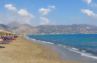 Iraklion at 42.9km (E) Ammoudara (GR: Αμμουδάρα) is four kilometre long sandy beach that stretches from the west end of Heraklion to Linoperamata near the village of Gazi. The sand is fine and blond and extends several metres to the land and the sea is clear and safe. The predominant winds during the summertime are N, N-W usually "meltemi" that get more fresh at the western end of the beach, where the windsurf school is located. Along the shore there are hotels, some of them very large complexes, taverns, restaurants, bars, cafes etc that offer umbrellas and sun-beds on the beach. There are also lifeguards in some spots. The area in general is touristic and offers a full range of facilities, among them the modern multiplex "Technopolis" with cinema and an open-air theater. Image Library
 Moires, Messara at 42.9km (SE) The monastery of Panagia Kaliviani is located at the 59th km on the road Iraklion-Phaistos. The monastery was built during the second Byzantine period. The small Byzantine chapel was painted with frescoes but most of them are today destroyed. The chapel was deserted until, during the Turkish occupation in 1873, an old small icon of the Annunciation of the Holy Mother was miraculously found there.and the monastery became a place of worship. 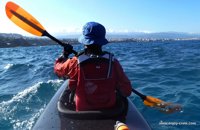 article by Stelios Asmargianakis at 42.9km (W) An article where Stelios Asmargianakis describes his experience of sea kayak, through a two-day trip to the north of Chania as it took place in mid February 2012. The whole journey is about 40 km, and is characterized by the absence of beaches for easy approaching and relaxing as well as exposure to the elements of the Cretan Sea.
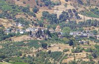
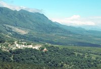
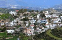 Messara, Iraklion South at 43km (SE) Kamilari is a quiet, traditional village, with a panoramic view to the endless olive groves of the Messara valley on the one side, and to the Libyan sea on the other side. It has been inhabited since the Minoan period. One of the seven wise men of the ancient world, Epimenidis, a great wise man and a soothsayer, lived in a small community outside Kamilari, called Metohi.
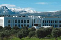 Voutes, Iraklion at 43.4km (E) The Foundation for Research and Technology – Hellas (FORTH) is one of the largest research centers of Greece with well - organised facilities and a highly qualified staff. It functions under the supervision of the General Secretariat for Research and Technology of the Hellenic Ministry of Development and consists of seven Research Institutes, which are located in various regions of Greece: Heraklion, Rethymno, Patras and Ioannina. The Foundation’s headquarters, as well as the Central Administration offices are located in Heraklion, Crete.  Mires, Messara Valley at 43.6km (SE) It is located north of Mires close to a small gorge, with springs and covered with trees. There are many churches in the village the most important one being the church of Agios Nikolaos, a domed church dated to the 13th century. The walls of the temple are hand painted with biblical scenes and pictures of saints
 Kenourgiou, Iraklion at 43.6km (SE) Priniás (GR: Πρινιάς) is a small village located 35km southwest of Iraklion town and 4km from Agia Varvara, at a height of 610 m above sea level. The village of Prinias lies on the border of three regions: Malevizi, Kenouriou and Monofatsi, and is recorded as forming part of all three regions in the censi. 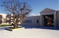 Voutes Iraklion & Rethymno at 44.2km (E) The University of Crete, is multi-disciplinary, research- oriented Institution, situated in the cities of Rethymnon and Heraklion. It is a University with a well-known reputation both nationally and internationally, with state-of-the art curricula and graduate programmes, considerable research activity and initiatives that reflect its dynamic character. It was established in 1973 and operated during the academic year 1977-1978. Today, approximately 10628 students attend the University. The University's staff consists of 580 Teaching and Research Staff members. Its' operation is supported by more than 400 administrative staff. 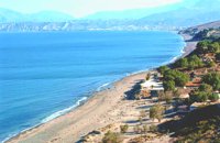 Messara Bay, Iraklion at 44.3km (S) One of the most beautiful sandy beaches of Crete, extends from a clump of rocks riveted in the shallow waters in the south to the Kalamaki settlement in the North. In Minoan times there used to be the ancient port of Phaistos. The antiquities lie just a few meters away from the sea.
Image Library
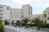 Stavrakia, Iraklion at 44.3km (E) The University Hospital of Heraklion (Pa.G.N.I.) is the largest hospital facility in Crete and one of the largest public hospitals in the country. The Pa.G.N.I. provides secondary and tertiary health care in a wide range of clinical specialties, diagnostic and laboratory tests. It is located 8km away from the city of Heraklion in the area of Stavrakia, next to the School of Medicine of the University of Crete Telephone: +30 2813 402111 & 2810 392111 Website: www.pagnh.gr/ 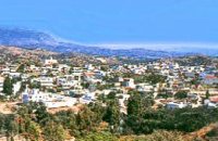 Messara, Iraklion South at 44.5km (S) The village of Pitsidia is located 65 km southwest of Iraklion at an altitude of 80 m a.s.l, just before the magnificent bay of Messara. The village with aproximately 700 inhabitants is the oldest village of the area and is refered (by S. Spanakis) that it was the place where the soldiers of Nikiforos Fokas, commander of the Byzantine army, settled. The army, famous for its bravery, came from Pisidia of the south Asia Minor, and this is probably the origin of the name Pitsidia.
Image Library
 Sfakia, Hania, Crete at 44.5km (SW) At the exit of the ravine of Imbros, near the south coast of Sfakia. It is located at an altitude of 200 m, 68 km from the city of Hania and 4,5 km from Hora Sfakion. The area is covered with olive trees and the view to the Libyan sea and the island of Gavdos in the horizon...
|

|
||
|
| |||

)
C
O
N
T
E
N
T
S
O
N
T
E
N
T
S