interkriti®
YOUR GATEWAY TO CRETE
HOME
CRETE FACTS
NAVIGATE
EXPLORE

Agia Galini
Triopetra
Kissamos
Chryssi Isl.
Agia Marina
Balos
Gavdos isl.
Georgioupolis
SAMARIA
IDA Mtn
Palaiochora
Agia Roumeli
Sfakaki
Bali
Kalamaki
Matala
Lassithi
Plateau Lendas
Tsoutsouros
Vianos
Myrtos
Sfakia
Plakias
Ierapetra
Makrygialos
ZAKROS
Vai
Sitia
Agios Nikolaos
Elounda
MALIA
Hersonissos
Gouves
Chania
Rethymnon
Heraklion
GORTYN
FESTOS
KNOSSOS
|
|
Crete
List Grid Map
Found
245
- Showing :
161 - 180
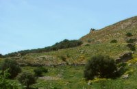
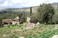
 Pediada, Iraklion at 37.6km (SE) Village of the area of Kastelli with 115 residents, Agia Paraskevi is situated 5 km northeast of Kastelli at an altitude of 400m. It is first mentioned in the Turkish census of 1671 as Agia Paraskevi tou Xourdou with 17 haratsia (head tax). It is very possible that Santa Venerata, a village mentioned in 1463 by Cardinal Bissarion, is the name by which Agia Paraskevi was known at that period. 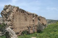 Gortyn archaeological site at 37.6km (S) The main acropolis of Gortyna was located on Agios Ioannis hill, to the northwest of the Agora. Acropolis can be accessed from its west side driving through Ambelouzos village to the direction of Gergeri. At a spot around 1.6 kms from Gortyna parking there is a footpath (not clearly signposted and maintained) that leads to the top of the hill. Once at the top you'll be rewarded by the magnificent view to the whole area and the archaeological site itself. The site was first inhabited in the Neolithic era and again at the end of Minoan times (1200 BC). Since then it was continuously inhabited until the Middle Byzantine period. From the first settlement only parts of walls, floors and hearths were preserved. In the 10th century BC a Geometric settlement was established fortified by a polygonal wall with towers at the corners. At the end of the 7th c. A.D., a small tripartite temple, dedicated to Athena Poliouchos was founded at the south side of the hill. From this temple some very important architectural sculptures were excavated. During the Early Byzantine period (5 - 6th century AD), a basilica was erected over the ruins of the geometric/archaic temple and, in the time of the emperor Heraclios (7th century A.D.) the last fortification with a castle in the center was built which still survives but in a very poor condition. Image Library
 Gortyn archaeological site at 37.7km (S) According to the myth, Zeus, disguised as a bull, coupled with Europe, whom he had brought from Phoenicia, under a deep- shaded plane tree on the banks of the Lethaios River. The offspring of this union were three sons, Minos, Sarpidon and Radamanthis. Later, the oldest Agora of the city of Gortyn, the Ekklesisterion (Congress hall), and the Roman Odeum were founded on this site. The plane tree was blessed and has remained ever green since that time. As his place of birth, the city was founded by King Minos himelf. According to the myth, it was on the fields of Gortyn that the bull given as a gift to Minos by Poseidon coupled with the Queen Pasiphae and out of this union Minotaur was born. Image Library
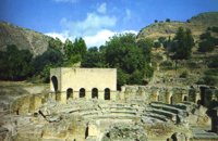 Gortyn archaeological site at 37.8km (S) The Roman Odeum at Gortyn is considered one of the best and the most important of its type on Crete. Is has been founded at the North part of the Ancient Agora of the City. This semicircular building consists of three main parts: a. The Cavea, connected with a domed corridor through three wide staircases; b. the Orchestra, which has an internal diameter 8,5 m. and was paved with white and blue marble slabs; c. The Scene, which had two entrances and the paraskenion, with mosaic pavement in geometric pattern. Statues of Muses stood in the niches. Initially the building was a circular Ekklesiasterion founded in the 5th c. BC. In the portico of this public building the Great Inscription with the Law Code of Gortyn dated to the early 5th c., stood. It was destroyed twice: in the 1st century BC, and again in 46 AD. After this last destruction it was reconstructed as an Odeum. The great Inscription is considered to be the largest Greek inscription, the Queen of all Inscriptions. Its first fragments were found by the French travelers and were bought by the Louvre Museum. The most part of the Inscription was found accidentally by local farmers in 1884 and was further explored F. Halbherr. It is a Law Code inscribed in the boustrophedon system of writing. It dates in the 1st half of the 5th c. BC and is the oldest Greek and European Law Code. It consists of twelve Deltoi and was built in the Ekklesiasterion of the 5th c BC. In this Code older laws, regarding the personal and family rights of the citizens of Gortyn, were codified. Image Library
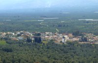
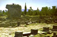
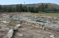
 Gortyn archaeological site at 37.8km (S) The oldest theater of Gortyna was on the south slope of the Profitis Ilias hill (Acropolis), opposite to the Odeum. Its cavea was partly cut into the rock and partly built. Its scene was built at the west side of the large court of the Agora, which covered the river Lethaios with a flat bridge. This scene, which H. Belli saw in the 16th c AD, was 120 m long and was already destroyed in 19th c. AD. On the proscenium there was an inscription of Julia Augusta and it was decorated with statues and relies, among which there was the statue of Europe on the Bull, with broken legs and head.This statue, as described by Admiral Spratt, is now kept in the British Museum and is dated to the 2nd c BC. 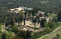 Messara, Iraklion South at 37.9km (S) Located in the valley of Messara, Gortys or Gortyn (GR: Γόρτυς or Γόρτυνα) is a must visit for all visitors to Crete. It was inhabited during Bronze Age times, but its rise to glory came almost a millennium after the downfall of the 'Minoans'. Gortyn was a prosperous city from around the middle of the 5th century BC through to the early 9th century AD, when it was finally destroyed by the Saracens (824AD), never to be rebuilt.
Image Library
 Amari, Rethymnon at 37.9km (SW) Sivritos (GR: Σίβρυτος) was an important and autonomous city of the ancient Crete. The city was built in the location that today is the village of Thronos. It was located on a hill dominating the valley of Amari. The name Sivritos is derived from the words si, that in the ancient eastern languages meant water, and the word vriti, that is of prehistoric origin and meant sweet. Therefore, Sivritos in the Minoan period meant sweet water. The derivation is also verified by the fact that near the hill where the city was located there are numerous sweet water springs. 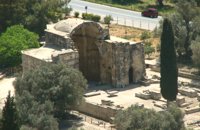 Gortyn archaeological site at 37.9km (S) Saint Titus church at Gortyn bears the name of the Apostle Titus, attendant of Apostle Paul, who was appointed as the first Christian bishop of Crete. It is one of the most important Byzantine monuments in Crete. The name was given to the ruined church by the excavators in the beginning of the 20th c., as they considered it to be the site of the saint’s martyrdom. After the discovery of the new Great Early Byzantine Basilica, just outside the village Mitropolis, its excavators have proposed that as the original bishopric basilica, as it is a century earlier than this, which in the local tradition is named and celebrated after Virgin Mary, “Kera”. The church has the plan of a three aisled inscribed cross with a low vault. It has been built of ashlar limestone. It has a narthex to the west and five entrances three of which form the trivelum with two columns. There were pillars instead of columns. Its architectural features date its foundation in the 2nd half of the 6th c. AD. Image Library
 Messara, Iraklion South at 38.1km (S) Agioi Déka (GR: Αγιοι Δέκα) is a town with 820 inhabitants in the plain of Messara, 170m above sea level, 43 km from Heraklion town and very close to the archaeological site of Gortyna. Its people are occupied mostly in agriculture - vines and olive trees. In the area there is is the oldest olive grove in Crete. The town is built on the ruins of the ancient town of Gortyn where the Holy Ten Martyrs have been martyred. 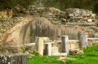 Gortyn archaeological site at 38.1km (S) The Great Nymphaeum (Nymphaion GR: Νυμφαίον), located to the north of Praetorium, was a marble construction with a covered cistern and fountains. Statues of Nymphs stood in the niches. The area of the remains is closed to the public but visitors can see it from a distance.
Image Library
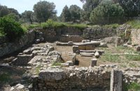 Gortyn archaeological site at 38.1km (S) The sanctuary of the Egyptian deities (1st-2nd centuries A.D.) is the only one, in the whole island, which is dedicated to the Egyptian gods Isis, Serapis and Anubis - Hermes although it is known that those gods are worshiped in other cities. The sanctuary consists of quadrilateral nave, arcade on the west, underground crypt in the south and a cistern outside east of nave. In the central alcove stood the statue of Serapis and the side statues of Isis and Hermes - Anubis. In the southern part of the temple was oblong space, underground crypt purification and a small cictern. The final construction phase of the temple dates to the 1st / 2nd century. AD, in accordance with dedicatory inscription. Image Library
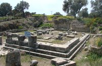 Gortyn at 38.2km (S) The Temple of Apollo Pythios (Pythian Apollo) located in the center of the ancient Agora, was excavated in 1887 and was the largest temple and the religious center of ancient Gortyn until the introduction of Christianity and the founding of the basilica of St. Titus around 500 AD. The first building of the seventh century. BC was a four-sided enclosure with four wooden pillars in the center to support the roof. The exterior walls and stairs of the crepis were covered with archaic inscriptions. In the Hellenistic period a monumental anteroom was added while columns with inscriptions were placed between the pillars. Alterations and additions were made during the Roman period. Outside the temple was built a magnificent altar on a stepped base while in the west of the temple was built a small theatre. In the middle Byzantine period in the vicinity of the temple, which had been abandoned, were built houses and aqueducts. Many finds have been made in the temple among which the colossal statue of Apollo Pythios and many inscriptions with administrative and law content of the Archaic and Hellenistic period. Dates: 7th c BC; Hellenistic; 2nd c AD. Image Library
 Gortyn at 38.2km (S) The Praetorium was the seat and residence of the proconsul of Crete. It is divided into two parts: the administrative section, in which the central building is the basilica, and the more "private" sector. The preserved ruins are dated to the 2nd century A.D. and seem to have been repaired in the 4th century A.D. This totally excavated building is the largest in the whole City of Gortyn. The earliest constructions have suffered successive alterations in a long period of eight centuries. New structures were erected on the ruins of the earlier sometimes incorporating parts of them. In the 1st c AD the Praetorium consisted of a peristyle court 1000 sq.m. and large halls to the north and west. This first Praetorium was destroyed by an earthquake in the time of the Emperor Trajan (early 2nd c AD). It was reconstructed and a large Thermai complex was built at its east side. Some years later a large temple dedicated to the Augusts was built further at the east part. To the west of the Thermai the juridical basilica continued to function under a judge’s responsibility according to the inscriptions found there, and statues of the emperors and other officers were still standing there. All these famous buildings were destroyed by the large earthquake in 365 AD. In 383 the consul Oecumenius Asclepiodotus Dositheus, agreeing with the capital of the empire, took care of the construction of the new Praetorium. Image Library
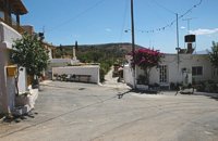
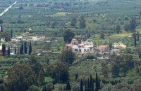
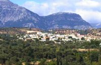 Messara, Iraklion South at 38.3km (S) Gallia is one of the oldest villages of the area. It is mentioned as a location in the Venetian records as early as 1577, and as a village with 120 residents since 1583. The renaissance tower in the village (still imposing although rundown) and the water fountains in the Kapeloniana area are proof of the passing of the Venetians. Part of the village, called Monohoro, is mentioned as early as 800 A.D.  Mires, Messara Valley at 38.3km (S) It is located north of Mires close to a small gorge, with springs and covered with trees. There are many churches in the village the most important one being the church of Agios Nikolaos, a domed church dated to the 13th century. The walls of the temple are hand painted with biblical scenes and pictures of saints
 Gortyn archaeological site at 38.3km (S) This unique monument has been excavated in the last thirty years. It is located on the road between the Saint Titos Church and the village Mitropolis. It is the largest early Byzantine basilica in Crete and among the largest in whole Greece. In early Byzantine period it was the cathedral of the city. The first five-aisled basilica was erected here in the early 6th c., in the years of the Emperor Justinian and stood for about 70 years. The central aisle had a mosaic pavement decorated in geometric patterns and animals. It is believed that there were mosaics of stone and glass tesserae on the walls, too. The other aisle had pavements of limestone slabs. The columns were made of white and gray white marble. Of great importance is the pulpit, which resembles that of Saint Sophia in Constantinople. It was a high exedra on low columns and two stairs for ascent and decent. The choirs stood under the exedra. After the destruction of the first basilica in 620 AD, a new basilica was built over its ruins in the time of the Emperor Heraclios. This basilica, following the fortune of the whole city, was destroyed after the strong earthquake of 670 AD.
Image Library
 Pediada, Iraklion at 38.4km (SE) Askoi (GR: Ασκοί) is small village in the municipality of Kasteli has 315 inhabitants. It lies in the foothills of the Dikti mountain, 11 km to the east of Kasteli and 8 km from Lyttos. Fr. Barozzi mentions it as Ascus, in the Pediada district, in 1577. Recently a ritual clay figurine of the Mid-Minoan period was fortuitously unearthed on a peak close to the village. The remains of a large building belonging to a peak sanctuary have been excavated at Amygdalokefalo to the NE of the village. A reference in a contract of 1271, mentions how Petri Comarii from the village (casali) Maski owes Ruggerino Temisano, resident in Chandax, 25 «mistata» of good Cretan wine from his vineyards in Maski. Among other natural beauties, the ravine at Aski is well worth seeing. On December 4th the village has a typical Cretan feast to honour Agia Varvara. And as in every Cretan village, raki and ‘mezedes’ are always available at the kafeneions. Image Library
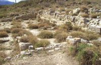
 Gortyn archaeological site at 38.4km (S) It lies at the south eastern part of the city and it is considered to be largest of all theaters in Gortyna. Although it is not yet excavated, it is believed that it had a two storeyed stage and its cavea was supported by 56 arches. The statue of the seated philosopher that we see next to the exhibition hall of the archaeological site was found here.
Image Library
 Village in Messara plain at 38.8km (S) Mitropoli (GR: Μητρόπολη) is a small village in the archaeological site of Gortyna in Messara plain. The village is mentioned for the first time in the Ducal archives of Candia in 1368 and later in the census of 1577 by Fr. Barozzi and in 1583 by Castrofylaka. Early mention of the settlement is to document the Ducal Archive of Candia in 1368, also mentioned by Fr. Barozzi in 1577 with the name and the Mitropoli Kastrofilakas in 1583. According to the census of 2001 it has 382 inhabitants. Main occupations of the inhabitants is the cultivation of vines, olives, vegetables, cereals and citrus fruits. At its north borders are located the ruins of the first cathedral of St. Titus, in which it owes its name.(Mitropoli = Cathedral). Image Library
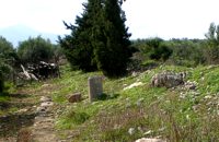 Gortyn archaeological site at 38.9km (S) The Hippodrome was located in the south part of the city of Gortyn, and was surrounded by columns. The central section was 374 metres long and 60 metres wide. Our information on the site is insufficient for the reason that there was never a systematic survey, or even a small excavation. What we see today of this magnificent monument are only some parts of columns and capitals.
Image Library
|

|
|
|
| ||

C
O
N
T
E
N
T
S
O
N
T
E
N
T
S