interkriti®
YOUR GATEWAY TO CRETE
HOME
CRETE FACTS
NAVIGATE
EXPLORE

Agia Galini
Triopetra
Kissamos
Chryssi Isl.
Agia Marina
Balos
Gavdos isl.
Georgioupolis
SAMARIA
IDA Mtn
Palaiochora
Agia Roumeli
Sfakaki
Bali
Kalamaki
Matala
Lassithi
Plateau Lendas
Tsoutsouros
Vianos
Myrtos
Sfakia
Plakias
Ierapetra
Makrygialos
ZAKROS
Vai
Sitia
Agios Nikolaos
Elounda
MALIA
Hersonissos
Gouves
Chania
Rethymnon
Heraklion
GORTYN
FESTOS
KNOSSOS
|
|
Crete
: Regional Interest
List Grid Map
Found
94
- Showing :
1 - 20
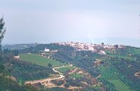 Malevizi, Iraklion at 0km (N) Petrokéfalo (GR: Πετροκέφαλο) lies 16km from Iraklion and 3km from Agios Myron at 340m a.s.l with 248 inhabitants. It is built on a rocky hillside. The hill' shape resembles to a human head and it is supposed that the village owes its name to this (petrokefali = stone head) . The settlement was fortified and lately were discovered significant ancient findings. The patron Saint is "Agia Paraskevi" and there is a village feast on the 8th September in her honour.
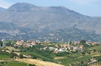 Malevizi, Iraklion at 1km (W) Pentamódi (GR: Πενταμόδι)one of the oldest villages in Crete, is located in the valley of Gazanos river, 17km from Iraklion and 4km from Agios Myron at 350m a.s.l with 278 inhabitants. At "Agia Paraskevi" a place with rich vegetation are organized every summer a series of cultural festivals. A fountain of the 15th century with the blazon of the house of "Quirini" is one of the significant monuments of the area. The patron Saint is "Agios Nikolaos" and there is a village feast on the 26th July in his honour. 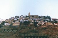 Malevizi, Iraklion at 1.8km (SW) Agios Myron, with 708 inhabitants, lies 18 km from the city of Iraklion to the south west. Its one of the most important villages of the area with interesting town planning and impressive samples of traditional architecture. Built between two hills it commands a panoramic view and the school's clock, its main characteristic, is visible from almost everywhere in the area of Malevizi. 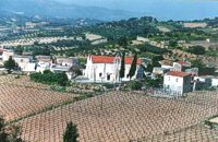 Malevizi, Iraklion at 3.2km (SW) Pyrgou lies 20 km from Iraklion and 1km from Agios Myron at 400m a.s.l with 354 inhabitants. It is built on a hillside overlooking the area, with panoramic view to the village of Kroussonas and the ravine of "Agia Irini". At the village's perimeter there are well maintained tower-like houses.  Malevizi, North - West Iraklion at 5.3km (W) Kroussónas (GR: Κρουσώνας) is an historical town built in a semi-circle on the eastern slopes of the Psilortis (the highest mountain in Crete), between the hills of Koupos and Livadiotis, at 460 meters above sea-level. It is at a distance of 21 kilometres from Heraklion. A magnificent 10kms route, ideal for nature-lovers is that from Kroussonas to the wood of Vromonero at 1300m a.s.l.
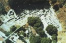 Tylissos at 5.7km (N) The houses of Tylissos were built during the LM I period (16th-15th century B.C.). Additions were made on House A in the LM II (15th-14th century B.C.) and on House C during the LM III period (14th century B.C.). The site was destroyed by fire in the 14th century B.C. and re - inhabited in historic times as is attested by ruins of later houses over the Minoan ones. Tylissos was excavated by Joseph Chatzidakis in 1902-1913. In 1954, in the course of restorations, parts of a paved court were revealed to the west, and a small stoa with five columns to the north of the Square of the Altar. The monuments were restored by the Archaeological Service (under the direction of Nicolaos Platon) in the period between 1954 and 1962. All three houses were again restored in 1990-1994. Source: The Hellenic Ministry of Culture 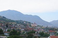 Malevizi, Iraklion at 6.2km (SW) Kato Asites (GR: Κάτω Ασίτες lies 23km from Iraklion and 5km from Agios Myron at 450m a.s.l with 1113 inhabitants. Beautiful town with traditional architecture especially the quarters "Notiko", "Prinos" and "Kastella" close to the monastery of Gorgolaini. Other interesting sights are: The thermae of the king of Prinias, The uninhabited settlement of Nisi with traditional houses, the caves "Lesta spilios" at Marias aloni, "Astirakou spilios", "Sarakina" and "Katsivli spilios" at Lyssogremia and "Melissa", The chapels of "Panagia" aged 800 years, "Agios Antonios" aged 1000 years, "Agios Georgios" and "Agia Paraskevi". The patron Saint is "Agia Paraskevi" celebrated on the 26th July . 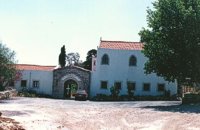 Malevizi, Iraklion at 6.4km (SW) The monastery of Aghios Georgios the Gorgolainis (GR: Αγιος Γεώργιος Γοργολαΐνι) is located on an altitude of 400 m close to the Kato Asites village. It survived through several revolutions and wars during the Ottoman occupation. 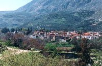 Malevizi, Iraklion at 6.9km (SW) Ano Asites (GR: Ανω Ασίτες) lies 24km from Iraklion and 6km from Agios Myron at 480m a.s.l with 423 inhabitants. A big part of the surrounding area is covered by forest on the eastern side of the mountain Psiloritis. Near the village there is the Byzantine chapel of Agios Antonios located in the ravine with the same name a place of exceptional natural beauty. From here passes the European Hiking Path (E4) which leads to the shelter "Prinos" ( of the Mountaineering Club of Iraklion - altitude 1100 m a.s.l.) located in a holly (=prinos) forest. 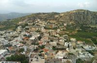 Iraklion at 7.3km (SE) The town of Profitis Ilias (GR: Προφήτης Ηλίας), or Roka for the locals, is found 20km south of Heraklion It is built on the top of two hills offering an unforgettable view to the surrounding areas. A natural fortification, due to its position, it has been suggested that ancient Lycastos was built here. It is also known as Kandli Kasteli due to the castle located at the summit of a rock southeast of the town. Nikiforos Fokas built the Byzantine castle of Temenos in the same location in 961 when he freed the island from the Saracens. His objective was to bring the city of Hantaka (Heraklion) into the castle of Temenos. However, this did not materialize and the city remained were it was. In the thirteenth century the castle of Temenos was occupied by the Genoese Pescatore, and later by the Venetians. The name Kanli Kastelli in Turkish means blood-painted castle, and took its name from a massacre of Turks by the Venetians and Greeks that took place here in 1647. 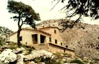 East Ida mountain, Iraklion at 9.5km (SW) Prinos refuge at Prinos on Psiloritis mountain (Ida), is at 1100 metres. It can sleep 25 people, it has cooking facilities, two wood burning stoves for heating and a rainwater tank. Access is through the village of Ano Assites in Malevizi around 22km from Iraklion. From there a two kilometres of dirt road leads to a place called Melisses and then a one-and-a-half hour walk along a footpath signed with red marks, to the refuge. Prinos hut was built in 1962 and was renovated around 1992. It is run by the mountaineering club of Heraklion. The view from Prinos to the north and east is great.  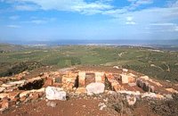 Archanes at 9.7km (E) Anemóspilia (GR: Aνεμόσπηλια). Anemospilia is an archeological site at the northern foot of Mount Yuchtas, in the prefecture of Heraklion in Crete. A rectangular building has been found which dates from the Minoan era and was destroyed by an earthquake in the 17th century BC. The building with three narrow chambers, each opening into a long corridor to the north, which extends along the whole width of the building. The area is enclosed with a stone wall and the whole structure has been interpreted as a shrine; in the central room was found a "xoanon" (statue) of the deity worshiped here. In the west room, where the altar stood, was uncovered, according to the excavator, the first human sacrifice to have ever taken place in Minoan times. (although this view has been challenged). The building at Anemospelia was used for only half a century, as it was suddenly destroyed by an earthquake in the middle of the 17th century B.C. The site was excavated in the summer of 1979 by John Sakellarakis.  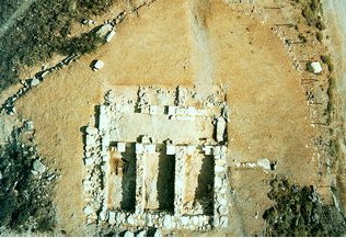 Aerial view 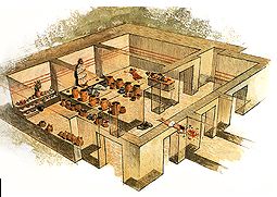 Shrine model Links: Minoan Religion (Foundation of the Hellenic World)  Iraklion at 9.7km (NE) The TEI, located on the beautiful island of Crete, was founded in 1983 in order to provide Higher Technical Education to the students of Greece. Since then it has expanded and developed considerably, and now comprises the Schools of Applied Technology (also in Chania and Rethimno) Health & Welfare Services Management & Economics (also in Agio Nikolao and Ierapetra) and Agricultural Technology assisted by he Departments of General Sciences, Foreign Languages and Physical Education. Students at the TEI follow courses for 4 years including lectures and practical work in laboratories. In addition, they complete a work placement and dissertation before graduating. Education at the TEI offers up to date training in technological subjects and prepares students to develop into skilled, responsible and qualified members of society. With a permanent teaching staff of 200 and approximately 10.000 students the TEI of Heraklion is a thriving academic community with an extensive library, student halls of residence, sport facilities and a health center. P.O. Box 1939 IRAKLIO, Crete, Greece, GR 710 04 Tel: Fax: +30 281 0379328 http://www.teicrete.gr  Iraklion at 10.4km (N) Ammoudara (GR: Αμμουδάρα) is four kilometre long sandy beach that stretches from the west end of Heraklion to Linoperamata near the village of Gazi. The sand is fine and blond and extends several metres to the land and the sea is clear and safe. The predominant winds during the summertime are N, N-W usually "meltemi" that get more fresh at the western end of the beach, where the windsurf school is located. Along the shore there are hotels, some of them very large complexes, taverns, restaurants, bars, cafes etc that offer umbrellas and sun-beds on the beach. There are also lifeguards in some spots. The area in general is touristic and offers a full range of facilities, among them the modern multiplex "Technopolis" with cinema and an open-air theater. Image Library
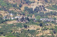 Kenourgiou, Iraklion at 10.7km (S) Priniás (GR: Πρινιάς) is a small village located 35km southwest of Iraklion town and 4km from Agia Varvara, at a height of 610 m above sea level. The village of Prinias lies on the border of three regions: Malevizi, Kenouriou and Monofatsi, and is recorded as forming part of all three regions in the censi. 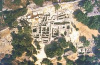 Archanes at 11km (E) Excavations at Phourni have brought to light 26 buildings, most of which had funerary use. The cemetery was used from 2400 B.C. until 1200 B.C. and each complex had more than one architectural phase. Most of the funerary buildings were used for many decades and contain successive burials. Excavations were begun in 1964 by Efi and John Sakellarakis and have been continued until today (1995) with short interruptions. Most of the buildings are preserved in good condition. 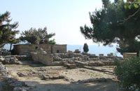 Archanes at 11.1km (SE) The Minoan villa at Vathypetro was most likely the residence of a local ruler. Its architecture is comparable to that of a "Little Palace": it has a central and west court, a small tripartite shrine, a three-columned portico, storerooms and workshops. It seems that the construction of the building was never completed. Interesting elements of its architecture are the installations of a wine-press in the south wing and an oil-press in the courtyard. 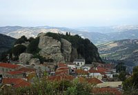 Kenourgiou, Iraklion at 11.3km (S) Agios Thomás (GR: Αγιος Θωμάς) lies at 530 m above sea level. It is 30 km away from Heraklion and has a panoramic view over the whole area to the SE of Aghia Varvara. Agios Thomas is a very old village and the first reference we have of it, is in a document of 1371, where it is quoted as a feudal property of Petrus de Medio, and again in a document dated 1380. Later, it figures in all the Venetian censi of the 16th and 17th centuries. In 1881, and in 1900, it figures as part of the Megali Vrisi municipality, with 344 inhabitants. From 1920, it figures in all the censi as a community with a continuously growing number of inhabitants. Nowadays there are over 800 inhabitants. 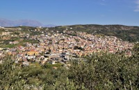 Archanes, Iraklion at 11.6km (E) A small traditional town (~4000 people) 15 km south of Iraklion on the foot of the sacred mountain Yiouhtas. Renowned for its excellent wine (from the varieties: vilana, kotsifali and madilari) and the archaeolocical sites and caves. In 1912, Xanthoudides noted the importance of Archanes, but Sir Arthur Evans was the first to characterize the site as palatial, declaring that Archanes was likely a Summer Palace for the Knossos kings. Spyridon Marinatos and N. Platon excavated minor areas in the region, but nothing supported Evans' theory. In 1964, J. Sakellarakis dug trial trenches at the Tourkoyeitonia site and uncovered the first evidence of a palace site. Since 1966, Archanes has been excavated by the Greek Archaeaological Society under the supervision of John Sakellarakis and Efi Sapouna-Sakellarakis. The small town of Epano Archanes, one of the most famous places of the Cretan land, with its colorful courtyards, teaches culture, taste, tradition, colors, aromas and life itself. The silvery grays of the olive groves, the red, pink, salmon and tiled walls, the blue and green shutters, the colorful bougainvillea boldly climbing the walls of the houses, the manicured flower beds, but also the elaborate, colorful signs in coffee shops and grocery stores. All this makes Archanes the most colorful village of Crete, but also of Greece. The town is full of atmospheric neighborhoods with well-maintained houses, painted in cheerful colors. At each step the visitor learns more and more about it. That's why the locals have taken care of it: the Folklore Museum, the Archaeological Museum, the sculpture workshop, the Museum of Cretan History and Tradition just outside. Image Library
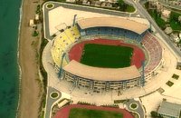 Iraklion at 11.6km (NE) Capacity: 26,240 (seated)- Location: The stadium is located in Heraklion (also: Iraklio) 3 km west of the city centre (at Lido beach)... The building began 15 years ago and the 2004 Olympic Games proved to be the golden opportunity for the Pancretan, as the Athens Organising Committee named it as one of the venues of the football tournament. It was inaugurated on 31 March 2004, when it hosted an international friendly match between the National teams of Greece and Switzerland. The stadium is currently the second largest stadium of the country. The stadium is actually part of a sports complex. A training ground with an 8-lane athletics track, Lido Indoor Hall, and a swimming pool are located right next to the Pancretan Stadium. Image Library
|
||
|
| ||


)
)
)
)
)
C
O
N
T
E
N
T
S
O
N
T
E
N
T
S