interkriti®
YOUR GATEWAY TO CRETE
HOME
CRETE FACTS
NAVIGATE
EXPLORE

Agia Galini
Triopetra
Kissamos
Chryssi Isl.
Agia Marina
Balos
Gavdos isl.
Georgioupolis
SAMARIA
IDA Mtn
Palaiochora
Agia Roumeli
Sfakaki
Bali
Kalamaki
Matala
Lassithi
Plateau Lendas
Tsoutsouros
Vianos
Myrtos
Sfakia
Plakias
Ierapetra
Makrygialos
ZAKROS
Vai
Sitia
Agios Nikolaos
Elounda
MALIA
Hersonissos
Gouves
Chania
Rethymnon
Heraklion
GORTYN
FESTOS
KNOSSOS
|
|
Crete
: Regional Interest
List Grid Map
Found
61
- Showing :
21 - 40
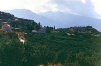
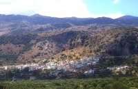 Mirabello, Lasstithi at 32.1km (N) Kritsa is one of the most picturesque towns in Crete, built amphitheatrically on a rock hill. It is located 11 km from Agios Nikolaos and has 2000 inhabitants. The people keep the old Cretan customs and the traditions and the town is considered one of the most important centers of the Cretan folk and weaving art.
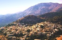 South east Iraklion at 33.9km (NW) Historical place with outstanding natural beauty, unspoiled villages and great beaches. The town of Ano Viannos is built amphitheatrically on the southern slopes of Dikti mountain at 560 m. above sea in a distance of 65km from Iraklion and 40km from Ierapetra. It preserves the traditional character with the narrow paved streets, the stone built houses - especially the "Plaka' quarter - the old kefeneios with tables under the plane trees and old churches such as Agios Georgios and Agia Pelagia with wall paintings dating back to the 14th century. There are a few accommodation facilities, banks, medical center, taverns, gas stations, shops etc. Ano Viannos is the seat of the municipality of Viannos.
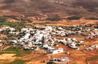
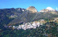 Sitia, East Crete at 34.2km (NE) Péfkoi (GR: Πεύκοι). A typical Cretan village, built at 420m above sea level, with narrow paved streets and old stone built house. There are many places worth to visit in the area. The folklore museum, housed in a small well preserved building located by the old school, provides information on the history and the day to day life of the village. At the top of the overlooking hill, named "Kastelopoulo" there is a building of the Late Minoan period which used to be a watchtower or a beacon. The 7km long road from Makrygialos to Pefkoi passes through the "Pefkiano" gorge, a wonderful landscape with plenty of pine trees (=pefko) who gave their name to the village. Approaching the village we see the dirt road that leads to the miracle working church of Agios Georgios Semekides, celebrating every year at November 3rd. 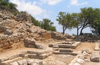 Mirabello, Lasstithi at 34.3km (N) Lato (Gr: Λατώ) was an ancient city of Crete, the ruins of which are located approximately 3 km from the small town of Kritsa. The Dorian city-state was built in a defensible position overlooking Mirabello Bay between two peaks, both of which became acropolises to the city. Although the city probably predates the arrival of the Dorians, the ruins date mainly from the Dorian period (fifth and fourth centuries BC). The city was destroyed ca. 200 BCE, but its port (Lato Etera or Lato pros Kamara), located near Agios Nikolaos was in use during Roman rule. There is some suggestion that the city was named after the goddess Leto (of which Lato is the usual Doric form) and may be mentioned in Linear B tablets as RA-TO. Lato also minted coins in antiquity,[3] bearing the likeness of the goddess Eileithyia who appears to have been the one particularly worshipped at Lato. Nearchus, admiral of Alexander the Great, was born at Lato. 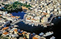 North East Crete, Lassithi at 35.3km (N) Agios Nikólaos (GR: Αγιος Νικόλαος), with 9.500 inhabitants, is the capital of the Lassithi province of Crete. It is built around a picturesque lake at the north-western side of the Mirabello bay, the biggest bay in Crete. Major administrative, cultural and communications center, Agios Nikolaos is one of the most developed tourist areas, not only in Crete but in Greece in general. Thanks to the beautiful coasts, the great sights and the cosmopolitan life, this lively city hosts every year thousands of visitors without losing one bit of its tranquility and traditional hospitality.
Image Library
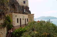 Sitia, East Lassithi at 35.3km (NE) The Monastery of Kapsa is located 40 km from the town of Sitia at the exit of the Pervolakia Gorge built against the steep rocks overlooking the Libyan sea. The exact time of the foundation of the monastery is still unknown, while some believe that it was in the 15th century. Until 1841 there were only a small chapel dedicated to the Saint John the Baptist and a few cells. Image Library
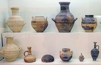 Agios Nikolaos, Lassithi at 35.6km (N) The Archaeological Museum of Aghios Nikolaos is one of the most important in Crete and has been in operation since 1969. It houses collections of very important archaeological finds from the whole of Eastern Crete, an area extending from Malia as far as Zakros. These are displayed in chronological order from the Neolithic period (5700 - 2800 B.C.) to the end of the Roman times (100 B.C. - 400 A.D.) Its showcases include more than 1350 vases from the 3rd millennium B.C. as well as gold and copper finds (the most ancient found in Crete).
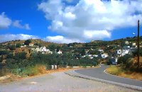
 Sitia, East Crete at 38km (NE) The village of Tourloti (GR: Τουρλωτή) is located in Eastern Crete, on the road from Agios Nikolaos to Sitia. Tourloti is 42 km from Agios Nikolaos and 27 Km from Sitia. Tourloti is a small, traditional village, the largest of a group of four, dotted across the hillsides in this area. It has changed little in the past few decades, and remains untouched by tourism. However, it retains a healthy vibrant Greek community, of families living and working in the local area. The village has a prominent church, primary school, two small mini-markets, a bakery, chemist, post office, two kafenions and one small traditional taverna. The narrow streets with white washed houses, flower filled alleyways, and glimpses of spectacular views, give the village a unique, timeless sense of tranquility, far removed from modern city life. It is the centre for several religious celebrations and festivals, especially over Easter and the summer months. 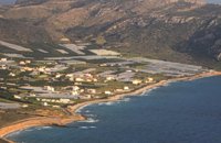 Sitia, East Crete at 38.2km (NE) Goúdouras (GR: Γούδουρας), is a coastal settlement near the Cape of Erythraio at the Libyan Sea. It is developing to a sea resort, there are sandy beaches, taverns and lodgings and a small shelter for fishing boats. There is also a remarkable production of early vegetables in green houses.
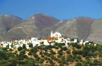
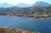 Sitia, East Lassithi at 38.9km (NE) A small picturesque village by the sea characterized as a landscape of exquisite, natural beauty. With joyful and peaceful inhabitants who constantly tease each other. It is located in Crete, north of Lasithi prefecture, between Agios Nikolaos and Sitia, at equal distance (30-35km) from the three major cities(Agios Nikolaos, Sitia, Ierapetra). Ideal place for holiday or special weekends. You will enjoy the most colourful sunset and the most beautiful daybreak from any other place. The serenity of the morning open view, with the sun rising from the sea, will be unforgettable. The small island, opposite the village, with the small church of Agios Nikolaos, offers a unique beauty to the landscape. 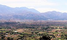 Lassithi, Dikti Mountains at 38.9km (NW) The Lassithi Plateau (GR: Οροπέδιο Λασιθίου, Oropedio Lasithiou), is a high endorheic plateau, located in eastern Crete, Greece on the mountain range of Dikti at an average altitude of 840 m, and in a distance of around 55km from Heraklion and 50km from Agios Nikolaos. The plateau is elliptical in shape with an E-W axis of 11km and the N-S of 7km. The plateau of Lassithi is renowned for its exceptional agricultural produce, the thousands (almost 15000) windmills that used to be there in the past, its significant historical role and for the unique cave of Psychro also known as "Diktaion Andron". Image Library
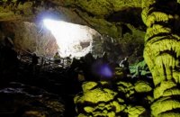 Psychro, Lassithi Plateau at 40.2km (NW) The cave of Psychro is one of the most important cult places of Minoan Crete. The excavators and several scholars identify the cave as the famous "Diktaian Cave", where Zeus was born and brought up with the aid of Amaltheia and the Kouretes, and which is connected with myths as this of the seer Epimenides who "slept" here, or the coupling of Zeus with Europa.
 Sitia, East Crete at 40.3km (NE) Etiá (or Ethiá GR: Ετιά) is a small settlement situated 2 klm away from the village of Papagianades driving to the village of Armeni. In a Venetian census was recorded with a population of 564. The village of Etia was at peak of its power around the Venetian occupation and from the presence of the St. John and St. Aikaterini churches one assumes that the village also existed through the Byzantine period as well. The village used to be private property of the De Mezzo family, a venetian family, where they built their three-storeyed house, the Seragio Serai House, which used to host Turkish officers as well during the Turkish occupation and can be seen nowadays. This House is considered to be one of the most important samples of the Venetian architecture in Crete. The church of St. Aikaterini used to be occupied by the Turks as a mosque until the Cretan revolution in 1897. At the south of village of Etia there is the hill of Etiani Kefala at an altitude of 715 m. where it used to be a sacred place but unfortunately nowadays looted. 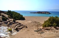 Sitia, East Crete at 40.4km (E) Koufonisi is a small island in the Libyan Sea just off the South East coast of Crete and the Cape of Goudouras. It is also named LEFKI and gave its name to the municipality. There is a cluster of small islets in the area like Makroulo, Strogylo, Trahila and Marmara. The island is deserted and in many spots it is covered with sand reminding an African landscape. Until 1976 the shepherds used to feed their sheep there but it was not inhabited. Later the Archaeological Offices of Eastern Crete under the authority of N. Papadakis began the excavations and the island proved to be full of ancient sites. A beautiful theater, made of stones, at the North West end of the island opposite the Marmaras islet was discovered. At the South East of the theater where a settlement was found, a villa with 8 rooms and a guest room was brought to light. The excavations also showed a workshop where the famous purple robes of the Romans was made. They also dig out an astonishing building, the Public Baths, dated back to 1st and 4th A.D. and ruins of an old temple. Boats depart daily from Makrygialos to Koufonissi (during the tourist season and only if the weather permits) offering day-trips. A short description of Lefki, by the archaeologist Nikos Papadakis: Koufonisi island covered today with sand and bushes, lies close to the southeast shore of Crete. From the Middle - Ages until today is nowhere referred that the island has ever been inhabited permanently. However scattered ancient remnants, drew the attention of the English admiral and traveller T B. Spratt in the mid - 19th century. His itinerary and visit was repeated by the English archaeologists Bosanquet and Curely in 1903 and by the American A. Leonard jr in 1970. The definite conclusion all the above travellers reached was that Koufonisi could be identified with the island Lefki of antiquity for which the people of Itanos and Hierapytna were contending as it is referred in the famous "Inscription of Magnetes" of 112 - 111 B.C. Excavations and archaeological research have since 1976 taken the responsibility to answer to the questions almost innate and consequent to the above conclusion and the result is undoubtedly impressive: An entire theater that could have housed a thousand spectators: a temple still containing fragments from the colossal cult statue: two private houses with 17 rooms decorated with mosaics and colourful walls: a system supplying water to the city through a series of vaulted cisterns and built pipes: a Minoan acropolis: cemeteries and last but not least the city of Lefki itself. Thus, slowly but steadily is unveiled the short but impressive presence of this small island nearby east Crete. Judging from the so far finds we can say that Lefki being one of the major centers of processing and trading purple, a symbol of authority and economic power soon became the object of rivalry among its neighbours. A series of diplomatic intrigue and fighting had occurred over the dominance of this prolific island. Later when its sources of prosperity were depleted the people of Lefki were exterminated through arms and fire: an invasion in the 4th century A.D. turned the historic island into ashes. On the basis of the existing ruins the importance it had for its neighbours and the fact that it was never again inhabited after its destruction we may describe Koufonisi by quoting a western journalist as Delos of the Libyan Sea. 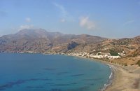 Monofatsi, South Iraklion at 40.5km (W) Tsoutsouros (GR: Τσούτσουρος) is a small village on the southern coast of Iraklion prefecture, with lovely beaches and a small harbour. The ancient city of Inatos, used to stand were Tsoutsouros is now. Inatos served as a port to Priansos a renowned city - state of the Hellenistic time, located near the village of Kasteliana. Tsoutsouros is a popular tourist resort especially with Greek families. There are many taverns and cafes most of them around the small harbour, and a good choice of apartments and hotels along the beach. Image Library
 Sitia, East Crete at 41km (NE) The village of Papagianades (GR: Παπαγιαννάδες) with ~160 inhabitants, is situated in the area of Lefki at an altitude of 480 m above sea level, approximately 90 km from Agios Nikolaos and 19 from the town of Sitia. It was first recorded in an Egyptian census in 1834 with 8 Christian families. It was also recorded by Chourmouzi Byzantios in 1842. In the 1881 census the village is recorded with a population of 77 pertaining to the Community of Handras. The Ai Lias hill just before entering the village is of local interest as well as the Monastirakia, a ruined Minoan settlement. There is also the church of Panagia Eleousa with frescoes dated back to the 14th century. The sightseer can sit and relax at the marvelous Panteli, a place in a gorge with lot of trees, joining the villages of Papagianades and Maronia. The chapel of Virgin Mary is worth visiting as well. 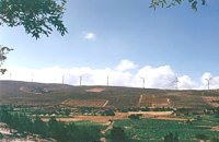 Sitia, East Crete at 41km (NE) The picturesque hilly village of Arméni (GR: Αρμένοι) is situated at the plateau of Ziros, 27 km from Sitia through Handra and 23 km through the villages of Papagianades and Etia. It was first recorded in a venetian census in 1583 with a population of 428. Today the village has approx. 400 inhabitants. The sightseer is impressed by the numerous windmills in the area. The church of Agia Sofia which used to be one of the most important churches of the Eastern Crete is also in Armeni. Amongst its icons, the Holy Mother presents interesting art features. The Cave of Holy Spirit is also in the area of the village of Armeni. In the wider area you can also visit the Etia settlement. 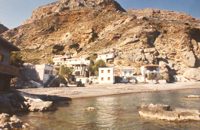 Monofatsi, South Iraklion at 41.4km (W) Maridaki (GR: Μαριδάκι) is a small coastal hamlet in the bay of Tsoutsouros on the southern coast of Iraklion prefecture. It is built at the end of the gorge of Ahendrias.
Image Library
 Sitia, East Lassithi at 42.3km (NE) The village of Handras (or Chandras (GR: Χανδράς) is in the Municipality of Lefki at the Armeni-Handras plateau and 27 km from the town of Sitia. First recorded in a venetian census in 1583 as Candra and Chandra with a population of 399 like today. Ancient Minoan sites were found at the Plakalonia area as well as at the Gras and Katrani places. There is a peak sanctuary at the hill of Xykefalo between Handras and Kasteliona at an altitude of 705 m. In spite of its looting a lot of ancient objects were found. The cave of Panagia Gouda is at the Handra region. This region includes the communities of Voila, Agios Panteleimonas and Pano Panteli. At Pano Panteli there is an old church the Metamorfosis in which there is an inscription that says: Petro Abramo was here in 1486. 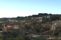 Sitia, East Crete at 42.9km (NE) The Agia Triáda (Holy Trinity GR: Αγία Τριάδα)) Community is 35 km from the town of Sitia at the end of the plateau of Ziros, with a population of 156. Long ago, the village was called Tso and today it is named after the Cathedral. Despite of the 8 km distance from the sea, its residents are very good fishermen. The Agia Triada Community includes the smaller communities of Dasonari, Livari, Achladi, Stalos and Amigdali. The archaeological search gave many indications of ancient features especially in Stalos where a Minoan settlement and some vaulted tombs were brought to light. In the area of Livari there is a Minoan cave the Alogara. |
||
|
| ||


C
O
N
T
E
N
T
S
O
N
T
E
N
T
S