interkriti®
YOUR GATEWAY TO CRETE
HOME
CRETE FACTS
NAVIGATE
EXPLORE

Agia Galini
Triopetra
Kissamos
Chryssi Isl.
Agia Marina
Balos
Gavdos isl.
Georgioupolis
SAMARIA
IDA Mtn
Palaiochora
Agia Roumeli
Sfakaki
Bali
Kalamaki
Matala
Lassithi
Plateau Lendas
Tsoutsouros
Vianos
Myrtos
Sfakia
Plakias
Ierapetra
Makrygialos
ZAKROS
Vai
Sitia
Agios Nikolaos
Elounda
MALIA
Hersonissos
Gouves
Chania
Rethymnon
Heraklion
GORTYN
FESTOS
KNOSSOS
|
|
Crete
: Regional Interest
List Grid Map
Found
141
- Showing :
81 - 100
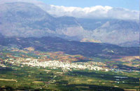
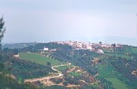 Malevizi, Iraklion at 37.7km (NW) Petrokéfalo (GR: Πετροκέφαλο) lies 16km from Iraklion and 3km from Agios Myron at 340m a.s.l with 248 inhabitants. It is built on a rocky hillside. The hill' shape resembles to a human head and it is supposed that the village owes its name to this (petrokefali = stone head) . The settlement was fortified and lately were discovered significant ancient findings. The patron Saint is "Agia Paraskevi" and there is a village feast on the 8th September in her honour.
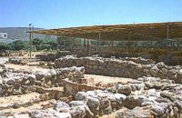
 Archaeological site in Malia, Iraklion at 38.3km (NE) The Palace of Malia, which covered an area of 7,500 sq.m. , was the third- largest of the Minoan Palaces and is considered the most "provincial" from the architectural point of view. The first Palace was built in 1900 BC and destroyed in 1700 BC when a new Palace was built. Following the fate of the other palaces in Crete it was also destroyed in 1450 BC. and the present ruins are mainly those of the new palace.
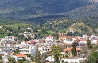
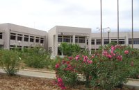 Gournes, Iraklion at 38.3km (N) A modern competitive organisation, IMBBC (part of the Hellenic Centre for Marine Research - www.hcmr.gr) is widely recognized as one of the leading institutes in the Mediterranean. Its installations are located at Gournes, near Heraklion, Crete, where its laboratories, administration, library and conference facilities cover 1.500 m2. It has a wide range of state-of-the-art facilities needed to carry out its basic and applied research. 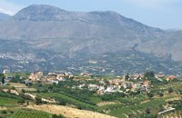 Malevizi, Iraklion at 38.3km (NW) Pentamódi (GR: Πενταμόδι)one of the oldest villages in Crete, is located in the valley of Gazanos river, 17km from Iraklion and 4km from Agios Myron at 350m a.s.l with 278 inhabitants. At "Agia Paraskevi" a place with rich vegetation are organized every summer a series of cultural festivals. A fountain of the 15th century with the blazon of the house of "Quirini" is one of the significant monuments of the area. The patron Saint is "Agios Nikolaos" and there is a village feast on the 26th July in his honour. 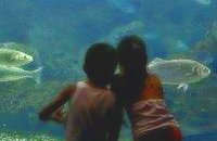 Gournes at 38.4km (N) The CretAquarium - Thalassocosmos (GR: Θαλασσόκοσμος) was officially opened in December 2005. It provides its visitors with a special experience, a trip to the underwater world of the Mediterranean Sea and its creatures. It is a unique park whose focus is on science, education, culture and recreation and whose goal is to promote, share and spread knowledge concerning the marine environment. Image Library
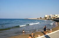 North - East Iraklion at 38.4km (N) Kokkíni Cháni (Kokkíni Háni - GR: Κοκκίνη Χάνι) is a beach resort located 14km east of the city of Heraklion, on the old national road from Heraklion to Agios Nikolaos. The beach from Vatheianos Kambos, to the west, to Gournes, to the east, is protected by small piers that in some places form small lagoons. It has fine sand and it is clean and well cared, with umbrellas and sun chairs, lifeguards and sea sports. The central street is lined with taverns, restaurants, bars, shops etc while the seaside street is less busy and ideal for walking. Image Library
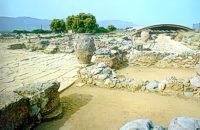
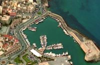
 Nirou Chani, North - East Iraklion at 38.5km (N) A Luxurious, two-storey house, built of large ashlar. The walls were strengthened by timber-frames and covered with a thick layer of plaster and marble slabs. The building has a paved courtyard, a shrine, storerooms for agricultural products, a staircase, and rooms with benches. It has been interpreted as a High Priest's house, due to the numerous ceremonial vessels it contained. The house was probably built in the 16th century. C. (MM III period) and, after its destruction by fire in the 15th century BC (LM IB period), was finally abandoned. The "Minoan Megaron" at Nirou was excavated in 1918 by St. Xanthoudides. In 1960, under the supervision of the Ephor of Antiquities N. Platon, the site was fenced and the building restored. The monument is consolidated and cleared at intervals by the 23rd Ephorate. Visiting Hours: Daily: 8:30-15:00, Monday: closed Entrance Fee:Free Admission 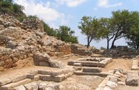 Mirabello, Lasstithi at 38.6km (NE) Lato (Gr: Λατώ) was an ancient city of Crete, the ruins of which are located approximately 3 km from the small town of Kritsa. The Dorian city-state was built in a defensible position overlooking Mirabello Bay between two peaks, both of which became acropolises to the city. Although the city probably predates the arrival of the Dorians, the ruins date mainly from the Dorian period (fifth and fourth centuries BC). The city was destroyed ca. 200 BCE, but its port (Lato Etera or Lato pros Kamara), located near Agios Nikolaos was in use during Roman rule. There is some suggestion that the city was named after the goddess Leto (of which Lato is the usual Doric form) and may be mentioned in Linear B tablets as RA-TO. Lato also minted coins in antiquity,[3] bearing the likeness of the goddess Eileithyia who appears to have been the one particularly worshipped at Lato. Nearchus, admiral of Alexander the Great, was born at Lato. 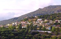 Ierapetra, Lassithi at 38.8km (E) It is a small village, 7 km to the north of Ierapetra, at an altitude of 212 m. According to tradition, the village took its name from a large olive tree. It produced at least 10 sacks of olives and it provoked admiration by its size, and mostly by its height (Makrylia meaning tall olive tree). The village is old and traditional, with original Cretan style houses that have remained untouched over the time, in a beautiful and healthy environment, with a view of the overgrown with olive trees plain, with a rich history and hospitable residents. 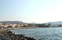 Gouves Beach, North - East Iraklion at 38.9km (N) Káto Goúves (GR: Κάτω Γούβες or simply Gouves) is a modern tourist resort with a complete tourist infrastructure to meet all demands. Organised beaches, large modern hotels, family apartments, restaurants, small tavernas, recreation centres, sports centre, shops, car and motorbikes for rent, small ports (marinas) for small boats, in a word Kato Gouves provides everything the visitors require to spend an agreeable and carefree holiday, enjoying the sunshine by day and the thrilling night-life in the numerous bars in the area. Just a few kilometers inland there are picturesque traditional villages, historic monasteries, caves and other natural beauties. Image Library
 Mires, Messara Valley at 38.9km (W) It is located north of Mires close to a small gorge, with springs and covered with trees. There are many churches in the village the most important one being the church of Agios Nikolaos, a domed church dated to the 13th century. The walls of the temple are hand painted with biblical scenes and pictures of saints
 Ierapetra, Lassithi at 38.9km (E) Between OLEROS and OLERIA there is the village Meseleroi, which took its name from the ancient OLEROS. It is situated at 10 km in the north of Ierapetra at an altitude of 360 m. Ancient Oleros flourished during the classical times, to be conquered by thepowerful Ierapytna. Oleria was a place of worship for Oleria Athena, with its famous statue, venerated by the residents of Oleria and Ierapytna. 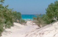 Ierapetra at 39.3km (E) A picturesque uninhabited small island of cedar forest, tempting golden beaches and the well preserved old church of Agios Nikolaos, only 8 miles off the port of Ierapetra, to the south. From the middle of May to the end of October, there are daily boat cruises to Chrissi island, departing from Ierapetra and Makrygialos. There is a bar restaurant at the south beach and a beach bar at the northern beach also known as "Golden Beach". The island belongs to the NATURA network due to its rare combination of ecosystems which form the habitats of several endemic species.
Image Library
 Messara plain, South - East Iraklion at 39.5km (W) The administrative center of the Messara Valley. Moires (GR: Μοίρες) is the biggest town in the Messara Valley with a population of approximately 5000 people. It has a police station, magistrate's court,post office, public PTT office, health center, and offices of most Greek major banks.
 Kenouriou, South Iraklion at 39.5km (NW) Zaros (Greek: Ζαρός), at an altitude of 340 metres, is a town with a lake and gorge nearby. It has a couple of hotels and it is 44 km from Heraklion at the southern foothills of Mountain Psiloritis. The population of 3,400, produce olive oil, sultanas, vegetables and spring water. There are a couple of fish farms that serve both trout and salmon. In Zaros, there are cafes near Lake Votomos, as well as a tavern that serves fresh trout called I Limni (The Lake). Close by is Rouvas Gorge, which is part of the Psiloritis mountain range and is on the hiking route known as the E4 European Walking Path. Nearby Zaros are traditional water mills which have been working since the 16th century, as well as archaeological sites and monasteries. Zaros is also famous for its water "ZAROS" bottled by a company called Votomos SA. 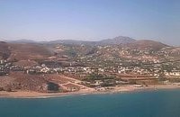 Iraklion at 39.5km (N) This 2 km long sandy beach was for years and still is the favorite beach of the people of Heraklion town. It is named after the river "Karteros" which outflows at the west end of it near the airport. The water is clean, the seabed is sandy with smoothly shelving and swimming is safe. The access is free in most parts except for some areas that are reserved for military personnel and the municipal beach "Akti" where visitors should pay an entrance fee in order to use the facilities. At the east end there are some very good taverns offering fresh fish among their specialties and are very popular with locals and tourists alike.
Image Library
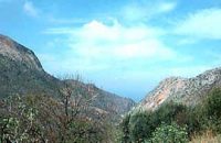
 Malevizi, North - West Iraklion at 39.6km (NW) Kroussónas (GR: Κρουσώνας) is an historical town built in a semi-circle on the eastern slopes of the Psilortis (the highest mountain in Crete), between the hills of Koupos and Livadiotis, at 460 meters above sea-level. It is at a distance of 21 kilometres from Heraklion. A magnificent 10kms route, ideal for nature-lovers is that from Kroussonas to the wood of Vromonero at 1300m a.s.l.
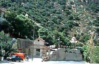 Mirabello, Lassithi at 39.6km (NE) At the side of the gorge of Selinari, at the 42 km. of the national road Iraklion - Agios Nikolaos is the small old chapel and the newly founded monastery of Agios Georgios Selinaris. In the monastery there is also a home for the aged founded in 1963. The small chapel was probably founded early in the 16th century AD, and ever since it is a place of worshiping. The people passing through the chapel stop to light a candle to the saint. The chapel is considered miraculous, there are various legends concerning miracles related either with healing of sick people or with divine punishment of people that did not pay the respect due to the saint.
 North - Central Crete at 39.8km (N) Iraklion (Heraklion or Herakleion GR: Ηράκλειον) is the largest urban centre in Crete, the capital of the region and the economic centre of the island. The first European civilisation, the Minoan civilisation, flourished on this land 5000 years ago. Currently the population of Iraklion is approximately 150.000 people. It is a very dynamic and cosmopolitan town, particularly during the summer period when thousands of visitors can be seen shopping in the market or visiting the museums and other places of interest. Today Heraklion is the top choice for tourist destinations in the Mediterranean. The city is also the commercial and scientific centre of the island. During the last 20 years the city has made remarkable progress in the academic and technological fields...
Image Library
 Selinari, Vrahassi at 39.8km (NE) Near the beautiful village of Vrahasi there is the imposing gorge of Selinari, formed by the mountain of Anavlohos (625 m) to the north and the mountain Fonias o Detis (818 m) to the south. The symbol of Crete, the Cretan wild goat (Agrimi or kri-kri) and the Griffon Vulture are two rare species that used to reside in the gorge. The authorities in Vrahasi intend to establish a center of protection of the local fauna and flora at the gorge of Selinari and to develop a wildlife station, to provide observation of the Griffon Vulture colony at the east side of the gorge of Selinari. The hunting is forbidden in an area covering 10 sq.km. around the gorge. |
||
|
| ||


)
)
)
C
O
N
T
E
N
T
S
O
N
T
E
N
T
S