interkriti®
YOUR GATEWAY TO CRETE
HOME
CRETE FACTS
NAVIGATE
EXPLORE

Agia Galini
Triopetra
Kissamos
Chryssi Isl.
Agia Marina
Balos
Gavdos isl.
Georgioupolis
SAMARIA
IDA Mtn
Palaiochora
Agia Roumeli
Sfakaki
Bali
Kalamaki
Matala
Lassithi
Plateau Lendas
Tsoutsouros
Vianos
Myrtos
Sfakia
Plakias
Ierapetra
Makrygialos
ZAKROS
Vai
Sitia
Agios Nikolaos
Elounda
MALIA
Hersonissos
Gouves
Chania
Rethymnon
Heraklion
GORTYN
FESTOS
KNOSSOS
|
|
Crete
List Grid Map
Found
27
- Showing :
21 - 27
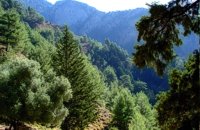 Sfakia, South Hania at 25.3km (E) The Samaria Gorge is one of the longest ravines in Europe (with a total length of 16 km) and offers one of the most spectacular hiking routes in Europe. Its width ranges from 150 m (widest part) to 3 m (narrowest part). The walk from Xyloskalo in the plateau of Omalos to the shores of Libyan sea at Agia Roumeli, takes 6 to 8 hours. The Samaria Gorge has been designated as a national park in order to protect its flora and fauna. It is one of the last shelters of the mountain goat of Crete (Cretan Ibex, common name : kri-kri). The flora is extensive, ranging from high cypress trees to flowers and herbs. The walking path follows the river which flows to small lakes and waterfalls. The Gorge is open to visitors from May to October. Image Library
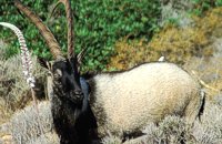 Cretan Ibex, Lefka Ori, Hania at 25.4km (E) Kri-Kri is the common name of the Cretan feral goat (Capra aegagrus ssp. cretica) which is the largest wild mammal on the island. Its grandeur, its bravery, its ability to observe without being noticed, its speed and its impressive horns are the features that were loved by the locals and made it a symbol of Crete and the untamed Cretan spirit. It lives mainly on the White Mountains and its local name is "Agrimi" (GR: Αγρίμι = the wild one) for the male and "Sanada" (GR: Σανάδα) for the female. Recent years, young kri-kris have approached the old village of Samaria, where they are fed by the park rangers and can be seen by the visitors. Kri-kris and goats are close genetically, as the hybridization that exists between them show. Kri-kri's size however is a good deal larger than that of a goat Kri-kris have a strong sexual dimorphism. Males are larger than females. They all have horns, with annual rings and knobs, from which their age can be easily calculated. Males have larger horns than females (up to 90 cm), which curve backwards. An other characteristic of the males is the beard, which rarely occurs in females. Their coat is short and brown in summer and brownish and denser in winter. They have a black line on the back, which extends from the neck to the top of the tail while at its shoulders the line intersects with another one that reaches the stomach. There are also black patterns on the front parts of their legs. There are numerous representations of Kri-kris on ancient sealstones, vases and coins, indicating the esteem in which they were held by the people of antiquity. Phototograph by Anastassios Sakoulis - www.photophysis.gr Image Library
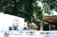
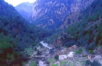 Samaria National Park at 25.4km (E) The deserted village of Samariá (GR: Σαμαριά) is located in the middle of the gorge of Samaria, 7.5 km away from Xyloskalo and 8.5km fro Agia Roumeli. This is the main resting point for the gorge walkers coming down from Omalos. There is a fountain with fresh drinkable water from the spring, benches and some tables, in the shade of tall plane trees where the visitors can relax and have some food (Only if they carry it with them). The village of Samaria was abandoned in 1962, when the area declared a National Park. The main occupations of its inhabitants were the wood cutting and bee keeping. Opposite the village are the old olive trees cultivated mainly for the residents' own consumption. Some of the village' s ruined housed are restored and are used today by the gorge authorities. One houses the guards' post, another the doctor's office and a third - the old olive mill - houses the information kiosk of the park where the visitors can view old pictures and folk art exhibits. Kri - kris (the Cetan Ibex) make their appearance here from time to time especially the young ones which are less shy. At the village's edge lies the byzantine church of "Osia Maria of Egypt" (Osia = Saint). The name Samaria is believed that is a corruption of the words "Osia Maria" or "Santa Maria". A little before the village (coming from Xyloskalo) in a small clearing lies the small church of Agios Geórgios. Image Library
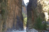 Samaria National Park at 25.7km (E) Pórtes (GR: Πόρτες - Gates) or Sideróportes (Iron Gates) is maybe the most striking point of the canyon. Here the canyon walls rise nearly 300 meters while the width is only 3.5 m. At this point the water runs almost all year round. The stratified limestone, the dominant rock of the canyon, forms specific geological formations, showing all the geological history of the canyon in the eyes of connoisseurs. Portes are 11 km away from the entrance of the Samarian gorge at Xylóskalo and 4km from the beach at Agia Roumeli.
Image Library
 Kissamos west coast at 26.8km (N) Platanos (GR: Πλάτανος = plane-tree) is located 10 km from Kasteli Kissamos. It is a large village, the second largest in Kissamos area, after Kasteli. It has approximately 1000 inhabidants, which are occupied mainly in green house and olive cultivation and tourism. There is a doctor's office, gas stations, many shops, rooms for rent and taverns. At the village's old square stand a plane-tree with a fountain. 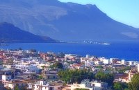 Kissamos, Hania at 28.5km (N) The beautiful town of Kissamos is located 42 km west of Hania and it is the capital of the Kissamos county. Kissamos is surrounded by beautiful landscape and has about 3.000 inhabitants. Kissamos is not a crowdy tourist resort, its development is based mostly in the wine and oil produce, and the agricultural products. Kissamos is built along a wonderful sandy beach. It is located where the ancient city of Kissamos stood. With Kissamos as a starting point you can visit the archaeological sites of Falassarna and Polyrinia, the Gramvoussa isles (pirate isles), the beautiful Georges of Topolia, Sirikari, the lagoon of Balos, the medieval villages, etc. 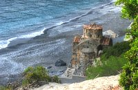 Sfakia, South Hania at 28.6km (E) Ágios Pávlos (GR: Άγιος Παύλος)is a beach on the shores of Sfakiá between Agia Rouméli and Loutró. The pine trees from the high cliffs above almost reach the sea and form a unique landscape. The beach is sandy with pebbles with no facilities except for a small tavern. It can be reached only on foot ( about 1 hour walk from Agia Roumeli) or by boat. The picturesque small church of Agios Pavlos (Saint Paul) a byzantine basilica of the 10th century A.D. with frescoes, lies just a few meters from the sea. It is built with stones from the beach itself on the spot where Saint Paul reportedly baptised people on his way to Rome.
Image Library
|
||
|
| ||


C
O
N
T
E
N
T
S
O
N
T
E
N
T
S