interkriti®
YOUR GATEWAY TO CRETE
HOME
CRETE FACTS
NAVIGATE
EXPLORE

Agia Galini
Triopetra
Kissamos
Chryssi Isl.
Agia Marina
Balos
Gavdos isl.
Georgioupolis
SAMARIA
IDA Mtn
Palaiochora
Agia Roumeli
Sfakaki
Bali
Kalamaki
Matala
Lassithi
Plateau Lendas
Tsoutsouros
Vianos
Myrtos
Sfakia
Plakias
Ierapetra
Makrygialos
ZAKROS
Vai
Sitia
Agios Nikolaos
Elounda
MALIA
Hersonissos
Gouves
Chania
Rethymnon
Heraklion
GORTYN
FESTOS
KNOSSOS
|
|
Crete
: Culture
List Grid Map
Found
26
- Showing :
21 - 26
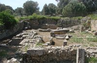 Gortyn archaeological site at 21.4km (NE) The sanctuary of the Egyptian deities (1st-2nd centuries A.D.) is the only one, in the whole island, which is dedicated to the Egyptian gods Isis, Serapis and Anubis - Hermes although it is known that those gods are worshiped in other cities. The sanctuary consists of quadrilateral nave, arcade on the west, underground crypt in the south and a cistern outside east of nave. In the central alcove stood the statue of Serapis and the side statues of Isis and Hermes - Anubis. In the southern part of the temple was oblong space, underground crypt purification and a small cictern. The final construction phase of the temple dates to the 1st / 2nd century. AD, in accordance with dedicatory inscription. Image Library
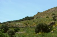 Gortyn archaeological site at 21.4km (NE) The oldest theater of Gortyna was on the south slope of the Profitis Ilias hill (Acropolis), opposite to the Odeum. Its cavea was partly cut into the rock and partly built. Its scene was built at the west side of the large court of the Agora, which covered the river Lethaios with a flat bridge. This scene, which H. Belli saw in the 16th c AD, was 120 m long and was already destroyed in 19th c. AD. On the proscenium there was an inscription of Julia Augusta and it was decorated with statues and relies, among which there was the statue of Europe on the Bull, with broken legs and head.This statue, as described by Admiral Spratt, is now kept in the British Museum and is dated to the 2nd c BC. 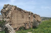 Gortyn archaeological site at 21.5km (NE) The main acropolis of Gortyna was located on Agios Ioannis hill, to the northwest of the Agora. Acropolis can be accessed from its west side driving through Ambelouzos village to the direction of Gergeri. At a spot around 1.6 kms from Gortyna parking there is a footpath (not clearly signposted and maintained) that leads to the top of the hill. Once at the top you'll be rewarded by the magnificent view to the whole area and the archaeological site itself. The site was first inhabited in the Neolithic era and again at the end of Minoan times (1200 BC). Since then it was continuously inhabited until the Middle Byzantine period. From the first settlement only parts of walls, floors and hearths were preserved. In the 10th century BC a Geometric settlement was established fortified by a polygonal wall with towers at the corners. At the end of the 7th c. A.D., a small tripartite temple, dedicated to Athena Poliouchos was founded at the south side of the hill. From this temple some very important architectural sculptures were excavated. During the Early Byzantine period (5 - 6th century AD), a basilica was erected over the ruins of the geometric/archaic temple and, in the time of the emperor Heraclios (7th century A.D.) the last fortification with a castle in the center was built which still survives but in a very poor condition. Image Library
 Voriza, South - West Iraklion at 24.9km (N) Close historical bonds link this monastery to that of Vrontisiou. The Varsamonerou Monastery lies in the surrounding fields of the village Voriza, 54.5 kms from Heraklion. The monastery is abandoned and, though its cells have been destroyed, its church has some of the most remarkable wall paintings in Crete.
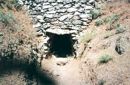 Amari, Rethymnon at 25.6km (N) The village of Apodoulou is located 55 km from Rethimno at an altitude of 450m. Remains of an extensive centre of the Old Palace period (1950-1700 B.C.) have been uncovered.at the site called Gournes, near the village of Apodoulou, at the west foot of Psiloreitis. The site dominates the Amari valley and controls the main route to the Messara plain. Excavations have brought to light three building complexes while tholos tombs of the Postpalatial period (1380-1200 B.C.) have also been located in the adjacent area. The first excavations on the site were carried out by S. Marinatos in the 1930's. During World War II it was excavated by the German Archaeological Institute, under the direction of E. Kirsten. Since 1985, systematic excavations have been carried out by the Greek Ministry of Culture in collaboration with the University of Naples. The most important monuments on the site are: Building A. It lies on the east side of the hill, to the south of the massive retaining wall. It had two storeys, as is indicated by the two preserved steps of a staircase. Decades of pithoi and other vases found on the ground floor suggest that it was used for storage. The house was destroyed by fire which followed an earthquake. Building B, located to the north of the retaining wall. It is a complex of rooms which originally communicated with Building A. Building C. It lies to the east of house A and belongs to a later phase of the settlement. Tholos tomb at Sopatakia. Tholos tomb with dromos, lying to the east of the road that leads from Apodoulou to Nithavris. The dromos is 7 m. long and the chamber has a diameter of 3.10 m. Three larnakes were found inside the burial chamber. Dated to 1380-1200 B.C. Source: The Hellenic Ministry of Culture 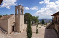 Zaros at 25.7km (N) This is one of Crete's most famous monasteries. It played an important role during the years of the Cretan Renaissance, both in the letters and the arts, and, during the last centuries of Venetian rule, it was known for its many scholars, artists and venerable monks.
|
||
|
| ||


C
O
N
T
E
N
T
S
O
N
T
E
N
T
S