interkriti®
YOUR GATEWAY TO CRETE
HOME
CRETE FACTS
NAVIGATE
EXPLORE

Agia Galini
Triopetra
Kissamos
Chryssi Isl.
Agia Marina
Balos
Gavdos isl.
Georgioupolis
SAMARIA
IDA Mtn
Palaiochora
Agia Roumeli
Sfakaki
Bali
Kalamaki
Matala
Lassithi
Plateau Lendas
Tsoutsouros
Vianos
Myrtos
Sfakia
Plakias
Ierapetra
Makrygialos
ZAKROS
Vai
Sitia
Agios Nikolaos
Elounda
MALIA
Hersonissos
Gouves
Chania
Rethymnon
Heraklion
GORTYN
FESTOS
KNOSSOS
|
|
Crete
: Regional Interest
List Grid Map
Found
35
- Showing :
21 - 35
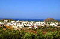
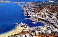 Mirabello Bay, Lassithi at 22.6km (NW) The area is touristic developed with many shops, restaurants on the shore, bars and several excellent hotels famous for their comforts and the variety of amenities offered. The lagoon of Elounda is shaped between the coast and a small peninsula of 7-8 km length ... Spinalonga, since antiquity, has protected the harbor of ancient Olous.
 Ierapetra, Lassithi at 22.8km (SW) It is a small village, 7 km to the north of Ierapetra, at an altitude of 212 m. According to tradition, the village took its name from a large olive tree. It produced at least 10 sacks of olives and it provoked admiration by its size, and mostly by its height (Makrylia meaning tall olive tree). The village is old and traditional, with original Cretan style houses that have remained untouched over the time, in a beautiful and healthy environment, with a view of the overgrown with olive trees plain, with a rich history and hospitable residents. 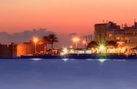 Ierapetra, Lassithi at 23.7km (SW) Ierápetra (GR: Ιεράπετρα), the southernmost town of Crete, combines a brilliant past with a present of economic growth and extension. The temperature seldom falls below 12°C, and the mean annual temperature is 20°C, also it is the sunniest and hottest region of Greece. It has a long sandy beach and clean blue sea, a picturesque port with the castle "Kales", an archaeological Museum, and many more attractions. Visitors will find a wide range of accommodation facilities and lots of interesting things to do and see in the town and the wider area as well.
Image Library
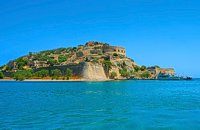 Elounda, Mirabello bay, Lassithi at 23.7km (NW) The island of Spinalonga (Gr: Σπιναλόγκα), officially known as Kalydon (Καλυδών), is located in the Gulf of Elounda in north-eastern Crete, in Lasithi prefecture, next to the town of Elounda. The official Greek name of the island today is Kalydon. Originally, Spinalonga was not an island, it was part of the island of Crete. During Venetian occupation the island was carved out of the coast for defense purposes and a fort was built there. A popular name for the island since Venetian rule is Spinalonga. During Venetian rule, salt was harvested from salt pans around the island. The island has also been used as a leper colony. Spinalonga has appeared in novels, television series, and a short film.
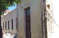 Ierapetra town, South Lassithi at 24.7km (SW) The museum was founded at the end of the 19th century, during the Turkish occupation of Crete and was housed in several buildings in the past. Today it is housed in the building of the Commercial Ottoman School, which is protected by a preservation order. The collection includes findings from the broader area and from the Minoan to the Roman period. Among the items are painted sarcophagi, lamps, vases, figurines, relief plaques. One of the most important exhibits of the museum is the Clay sarcophagus dated to 1450-1400 B.C.
Image Library
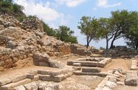 Mirabello, Lasstithi at 25.8km (W) Lato (Gr: Λατώ) was an ancient city of Crete, the ruins of which are located approximately 3 km from the small town of Kritsa. The Dorian city-state was built in a defensible position overlooking Mirabello Bay between two peaks, both of which became acropolises to the city. Although the city probably predates the arrival of the Dorians, the ruins date mainly from the Dorian period (fifth and fourth centuries BC). The city was destroyed ca. 200 BCE, but its port (Lato Etera or Lato pros Kamara), located near Agios Nikolaos was in use during Roman rule. There is some suggestion that the city was named after the goddess Leto (of which Lato is the usual Doric form) and may be mentioned in Linear B tablets as RA-TO. Lato also minted coins in antiquity,[3] bearing the likeness of the goddess Eileithyia who appears to have been the one particularly worshipped at Lato. Nearchus, admiral of Alexander the Great, was born at Lato. 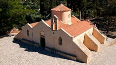 Mirabello, Lasstithi at 25.8km (W) The Panagia Kera of Kritsa, as it is called the Temple of the Virgin Mary (Kera), is 1 km to the north of the village of Kritsa in Merabello Lassithi, in a place called Logari, right on the road from Agios Nikolaos to Kritsa. The history of the church of Panayia Kera begins at least since the 13th century. 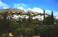 Sitia, East Crete at 26km (E) A picturesque town built at 260 m. above sea level, located at the end of the road from Sitia to the eastern part of the island, 38km away from Sitia and 19,5km from Palekastro. Zakros has 750 inhabitants, farmers, producing olive oil of excelent quality, stock breeders and fishermen. It is the commercial and administrative center of the area with the villages : Adravasti (75 inhabitants, 300m a.s.l.), Azokeramos (58 inhabitants, 230m a.s.l.), Kelaria (34 inhabitants, 250m a.s.l.), Klissidi (15 inhabitants, 220m a.s.l.) and Kato Zakros a small coastal village, site of the fourth large Minoan Palace, located 7.5km from Zakros at the bay of the same name. There is regular public bus transportation from Sitia to Zakros. The town and the wider area offers quite few facilities to the visitors, apartments for rent, restaurants cafes, shops etc. During the summer cultural events are taking place at the central square of the town, attracting both tourists and locals. The area is characterized by lush vegetation, due to the many springs and streams with running water, while watermills were built in some of them. 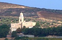 Sitia at 26.1km (E) It is an historical monastery of the 15th century, which collapsed in the earthquake of 1612 and was rebuilt with the financial aid of the Venetians. During the Ottoman conquest of Crete, the monastery was destroyed and devastated by the Turks. In 1704 the monastery was declared stauropegion. During the Ottoman occupation there was a school in the monastery, while, after 1870, it was founded there a school of mutual teaching. The Monastery is a stauropegion fortress. The main building of 800 m2 has three floors, which are divided into cells, guest - houses, kitchens, the abbot' s residence and warehouses. The katholicon is a two-aisled church; the northern aisle is dedicated to the Virgin, and the southern posterior aisle, to St John the Theologian. The monastery' s characteristic bell tower bears relief crowns and crosses with inscriptions and the date 1558. In the Monastery, there is also an interesting Museum.
Image Library
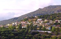
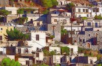
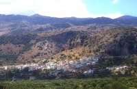 Mirabello, Lasstithi at 26.4km (W) Kritsa is one of the most picturesque towns in Crete, built amphitheatrically on a rock hill. It is located 11 km from Agios Nikolaos and has 2000 inhabitants. The people keep the old Cretan customs and the traditions and the town is considered one of the most important centers of the Cretan folk and weaving art.
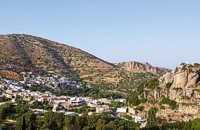 Ierapetra, Lassithi at 27.2km (W) One of the most beautiful parts of the hinterland of Ierapetra is occupied by the picturesque village of Kalamafka. It is situated on the edge of the Lassithi mountains, an area known for its impressive diversity in landscape. Kalamafka sits at an altitude of 480 meters, 15 kilometers from the town of Ierapetra and 25 kilometers from Agios Nikolaos. Kalamafka is a picturesque, large, and prosperous village surrounded by unique natural beauty. The springs at Kefalovryso, with its plane trees and lush vegetation, as well as its old historical churches, gorges, and springs, attract visitors due to the oasis-like coolness it offers in this otherwise dry and hot region. The village's wealth lies in its water sources and the vitality of its residents, who resist urbanization. Another reason for Kalamafka's enduring population is its advantageous location, as it is centrally positioned between the north and south coasts of the island, drawing daily visitors from Ierapetra and Agios Nikolaos. History: The village derives its name from "Kali Afkla," a wooden channel that was once used to transfer water from one riverbank to another at the springs of Kefalovryso. Another explanation for the name is that the rock formation on Kastelos Hill resembles a Greek Orthodox priest's hat (kalymafki). Kalamafka, known as ancient Larisa, has been inhabited since the Minoan era. In the Psathi area, along the road to Ierapetra, archaeological findings such as human skulls, clay pots, spearheads, and various grave goods from the sub-Minoan era have been discovered. The geographer Strabo mentions Kalamafka, ancient Larisa, as follows: "And in Crete there is the city of Larisa, which now is united with Ierapytna, and from which the plain below, called Larision, takes its name." The god protector of ancient Larisa was Asclepius, and this is why the Medical Association of Lassithi has adopted the figure of a statuette discovered on the Kastelos peak, which overlooks the village and served as a peak sanctuary according to Mr. Michalis Pytikakis. Larisa was conquered around the 3rd century B.C. by Ierapytna, and its residents were relocated as per the terms of the treaty. Evidence from subsequent historical periods suggests that the Kalamafka area has been continuously inhabited due to the presence of the water sources of Kefalovryso. Place names like Kastelos, Mesokastela, and Larisakia attest to its historical significance. Kastelos Hill, serving as the seat of a feudal lord during the Venetian rule, had 435 residents in 1583. It boasted several notable Byzantine and post-Byzantine churches, along with numerous chapels. During the Turkish rule, it was a breeding ground for prominent chieftains like Nikolaos Foniadakis and Ioannis Baritakis. The village's history is marked by struggles and sacrifices that cannot be easily summarized. Today, Kalamafka is a vibrant village with a growing population. It has a two-seat school, a nursery school, a cultural association, numerous coffee houses, and seven taverns. The natural landscape, often referred to as "Chinese" due to its small rock pillars with bonsais, stone formations, and Kastelos Hill with its 224 steps, is considered a monument of natural history. Kalamafka offers visitors a wealth of attractions, including caves, rock paintings, the Havgas gorge, an ancient olive press, and the churches of Saint John and Saint Anthony. The taverns, shaded by plane trees and surrounded by running water, serve traditional and delicious local dishes, including the traditional "klostenios" halva and skyfomakarounes (local pasta). The sounds of the lyra, violin, and lute add to the ambiance, pleasing both locals and foreigners. There are indeed many compelling reasons to visit Kalamafka. By Toby Robert Image Library
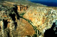 Zakros, Sitia, East Crete at 28.7km (E) Within a few distance from the town of Zakros, starts the Gorge, which ends at the bay of Kato Zakros, almost near the Palace area. This gorge is of outstanding beauty, with large caves in its walls. In those caves were discovered tombs dated to the Minoan period, and finds of great archaeological importance. That is the reason why the caves are named "The Caves of Dead" and the gorge "The Gorge of Dead". Because of its natural beauty and archaeological significance the gorge attracts numerous visitors every year. Image Library
 Sitia, East Lassithi at 29.1km (E) Palekastro (Palaíkastro GR: Παλαίκαστρο) is a lively, unpretentious town, at the east coast of Crete 20 km. away from Sitia and the seat of the Municipality of Itanos. It was named after an old castle. Its sources main income is agriculture and tourism. Although the town is growing, it manages and retain its character and charm. The town's square is the center of activities and is lined with cafes and taverns. Many a pleasant hour can be passed here, watching the world go by. During the summer months, weddings are often held in the village, with the huge wedding feast taking place in the square, to which everyone is invited. A chance to try your hand at Cretan dancing! 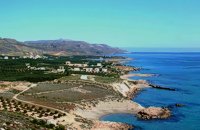 Sitia, East Crete at 29.7km (SE) Xerókampos (GR: Ξερόκαμπος) is a beautiful coastal settlement in a place of natural beauty. The distance from Ziros is 20 km and from Zakros 11 km. The wonderful beaches, the healthy climate and the important ancient places of interest attract both Greek and foreign visitors. The settlement offers a infrastructure of small hotels, apartments, taverns, super markets and supporting facilities. Xerokampos is an old settlement. It is first recorded in the 1583 Venetian census. The ancients were certainly aware of the beauty of this place and its important position and the site has been inhabited since the Minoan times. The settlement would appear to have been at the spot called Katsounaki and on Trahilas hill a peak sanctuary already looted was discovered. There are important ancient sites from Hellenic times on the hills of Antisternia and Farmakokefalo. At Farmakokefalo where the excavations are under the authority of the archaeologist N. Papadakis an important town, mainly of the Hellenistic era was brought to light. It is possible that the town is Ambelos which various literary sources and correlation place in this area of Crete. Image Library
 Ierapetra, Lassithi at 29.8km (SW) The village of the rising sun, as its name declares. The golden rays illuminate Anatoli, the hanging rocks, the Holy Cross church, Drygies, Karkasa, and give the impression that the sun keeps rising. It is an old, historical, traditional village, situated at 17 km in the north-west of Ierapetra, at an altitude of 600 m. Its housesare visible from the plain and seem like white doves, nested in the fortified mountain of Anatoli. A privileged place, it has been a cradle of men of letters, Notaries, University professors, with great history and civilization.In the 70s, most of Anatoli’s residents got down to the plain and worked in the glasshouse cultivations. They founded, along with residents from other villages the settlementsStomio, Nea Anatoli, Ammoudares. The small picturesque village Kalogeroi, which, according to tradition, was built by a Turkish Aga, is part of Anatoli. It is referenced sincethe era of the Venetian rule. In 1583, along with Kalogeroi, it had 666 residents. In 1951 it had 897 and in 2001, along with Nea Anatoli, it had 1235 residents. The Tower of theVenetian feudal lord still lies in ruins in the north of the village. It nurtured important men of letters, such as Antonios Damilas, scribe and printer, Neilos Damilas, scholarlypriest-monk in the Karkasia Monastery, Dimitrios Damilas, brother of Antonios, scribe and printer in Milan, who published the “Greek Grammar” in 1476, Anthimos Donos,and Ioannis Olokalos, whose notary documents have been recently published. The latter had his seat in Drygies, a wonderful location in the east of the village with runningwaters, a tavern with a view of Ierapetra and the little church of Saint Foteini. Anatoli was an important intellectual center, having a school during the Venetian rule and a secretschool during the Turkish rule.The area of Anatoli, a fortified position, produced great fighters during the Turkish rule, such as Emmanuel Lakerdas, general chief of Ierapetra, Iakovos Mahairas, AthanasiosBarberakis and Georgios Bekiaris.Its history and struggles were imortant in all the historical periods. It has many ecclesiastical monuments, Monasteries and Byzantine icons of great art.The old traditional settlement of Anatoli has remained untouched by time, with its stone-built houses, the alleys, the old Kato Vrysi. Five years ago, it entered a program ofrenovation, was characterized as a traditional settlement and today houses and tourist lodgings of exceptional esthetics are built in stone. In a few years, Anatoli of Ierapetra willbe one of the most beautiful villages of Crete, with its wonderful climate, its extraordinary view, its incomparable natural landscape on which the Museum of Natural Historyof Crete has worked and about which it published a relevant document.Anatoli as well as its residents have to this day been successful in the agricultural, tourist and intellectual sectors. Personalities coming from the village dominate the political,social and intellectual life of our country. Anatoli was a Municipality in the beginning of the 20th century, then a Community and today a Local Department ofthe Municipality of Ierapetra, building its future on solid foundations. Hosting important cultural events, with itshistorical, folkloric and musical contributions, it is a center of attraction of bothlocals and foreigners. With two taverns, two coffee houses, a renovatedold school and hospitable residents, it satisfies the most demandingvisitors. Anatoli is even rich in snails and wild mushrooms.
|
||
|
| ||


C
O
N
T
E
N
T
S
O
N
T
E
N
T
S