interkriti®
YOUR GATEWAY TO CRETE
HOME
CRETE FACTS
NAVIGATE
EXPLORE

Agia Galini
Triopetra
Kissamos
Chryssi Isl.
Agia Marina
Balos
Gavdos isl.
Georgioupolis
SAMARIA
IDA Mtn
Palaiochora
Agia Roumeli
Sfakaki
Bali
Kalamaki
Matala
Lassithi
Plateau Lendas
Tsoutsouros
Vianos
Myrtos
Sfakia
Plakias
Ierapetra
Makrygialos
ZAKROS
Vai
Sitia
Agios Nikolaos
Elounda
MALIA
Hersonissos
Gouves
Chania
Rethymnon
Heraklion
GORTYN
FESTOS
KNOSSOS
|
|
Crete
: Sightseeing
List Grid Map
Found
35
- Showing :
21 - 35
 Akrotiri, Hania at 26.2km (NW) At a time that living organisms are disappearing at an alarming rate, especially through habitat destruction, the Park for the Preservation of Flora and Fauna of the Technical University of Crete, which extends to 30 hectares, constitutes a small but important area where native plants and co-existing animals are protected and can develop without human intervention. Up to now 250 different plant species that grow naturally in habitats of the Park have been identified, while their systematic documentation is still in progress. The development of new ecological units (“habitats”) began in areas of the Park that have been cultivated in the past. These will include plant species of Crete that do not grow naturally in the Park. Two such units, the wetland and the coastal habitats have already been launched. www.park.tuc.gr/ 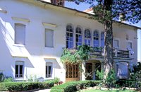 Halepa, Hania at 26.6km (NW) After the scientific and administrative services of the Foundation "Eleftherios Venizelos" were transferred to the former Vloom Mansion, in 2005, the Venizelos residence remained the Foundation's headquarters and it has been converted into a Museum, a commemoration site for Eleftherios Venizelos. The residence bears the imprint of Eleftherios Venizelos and the building has maintained its original form, of the years he lived there. The furniture of the decade 1925-1935 was selected by Venizelos himself and his wife Elena, and was brought from Athens and abroad. Decorative objects and paintings of the period, original photographs and personal items of significant value decorate the interior of the residence. Website:www.venizelos-foundation.gr 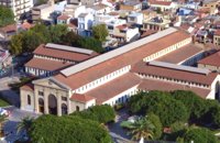 Hania town at 27.6km (NW) The Market, impressive for its size and shape, is built in the shape of a cross with 76 shops grouped according to their wares in the four arms of the cross. The south façade is particularly well constructed out of chiseled limestone, in the architectural style of the local tradition, developed during the Venetian period. Its construction was completed in 1913 and the formal opening was made by Eleftherios Venizelos on 4th December 1913 as part of the celebrations for the Unification of Crete to Greece.
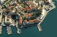 North West Crete at 27.8km (NW) Hania (or Chania GR: Χανιά) is the capital of the Prefecture of the same name and the second biggest town in Crete, with a population of 60.000 inhabitants. It lies (Coordinates 35°31' N 24°1' E ) along the North coast of the island, about 55 km west of Rethymnon and 140 km west of Iraklion (Heraklion). Hania's old town (although it was heavily bombed by Germans in World War II) is considered as Crete's most beautiful urban district, especially the Venetian harbour with its 16th century lighthouse and the Mosque of the Janissaries ("Giali Tzamissi", built 17th century). Many of the old buildings have been restored as hotels, restaurants, shops and bars, making the old town a lively and colourful place, especially during the tourist period.
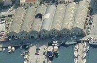 Hania, old port at 27.8km (NW) The south complex was completed in 1599, with the construction of 17 Neoria. Today only 7 survive out of the 17. In their original form they were open on the side of the sea. The ceilings are arched, and they are connected with arched openings of the same thickness as the walls.
 Hania at 27.9km (NW) The museum is housed in the katholikon of the Venetian monastery of St. Francis. During the period of the Turkish occupation it was the Muslim mosque of Yussuf Pasha, while in modern times it was used as a cinema or a storehouse for military equipment. Since 1963 it has been functioning as the Archaeological Museum of the city. Apart from the permanent exhibition, the museum houses temporary exhibitions in the frame of certain local events 25 Chalidon Str., tel. +30821 90334 It contains impressive finds from the excavations of the ancient city of Kydonia, from Idramia, Aptera, Polyrinia, Kissamos, Elyros, Irtakina, Syia, Lissos, Chania, Axos, and Lappa. 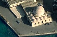 Venetian port, Chania at 28km (NW) The temple Kioutsouk (small) Hassan or Giali Tzamisi (seaside mosque), as it was commonly called, a brilliant sample of Islamic art of the Renaissance was a work of an Armenian architect, who had constructed another similar mosque in 'Spaniako', a village in the county of 'Selino'. The mosque, in the yard of which there were palm trees and graves of pashas and janissaries, stopped operating in 1923 and today it is restored without the small and picturesque minaret demolished in 1920.
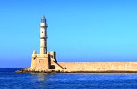 Hania harbour at 28.2km (NW) Chania lighthouse, the jewel of the city, is one of the oldest light houses, not only in Greece and the Mediterranean, but also in the world. The lighthouse (Faros GR: Φάρος) is a major attraction in the old port of Chania especially at night when it's lit up. The tower is 21m high and is built on a stone base, located at the end of the old harbour's pier opposite to the fortress of "Firkas". Visitors are not allowed to enter the tower. Chania lighthouse was first constructed by the Venetians around 1595 - 1601, and it took its final form, in the shape of a minaret, during the Egyptian Period (1831 - 1841) in around 1839. After the latest restoration, completed in 2006, it was given the formation of the Venetian period. The minaret look is still evident however. 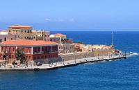 Hania harbour at 28.2km (NW) The fortress on the northwest side of the port was constructed to protect the entrance of the port and maintains its Turkish name "Firká" (Firka=barracks). A chain from "Firka" to the lighthouse blocked the entrance to the port in case of intrusion. The fortress was the headquarters of the Army Commander of the city. 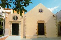 Hania, old town at 28.2km (NW) The Franciscan monastery of San Salvatore, that houses the Byzantine and Post-Byzantine Collection of Chania, was built on the west side of the fortress of Chania, in three phases from the 15th century until the late Venetian period (middle of 17th century). The extensive restoration of the church made it possible to identify more clearly the various building phases of the monument, unify the space, and display its austere, uncluttered architectural features to good effect. The original church, which probably dates from the 15th century, was the small domed section on the east side. 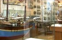 Hania, Venetian port at 28.2km (NW) A two storey house, located at the old port of Hania, with a total area of 840 m2. The exhibition includes about 2,500 exhibits, such as models of ships, different kinds of naval instruments and devices, paintings, heirlooms, gleanings from the sea bottom, shells, photographs etc., which are divided in 13 units, covering chronologically all the periods. 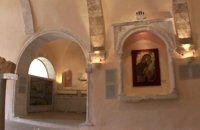 Hania, old town at 28.3km (NW) The wealth of archaeological material yielded by excavations conducted over many years by the 13th Ephorate of Byzantine Antiquities in the county of Chania, and also by retrieval of material and donations, forms a Collection that records, with great clarity, the history of the westernmost county in Crete from Early Christian times to the period of Turkish rule. Representative examples of this Collection are displayed in the church of San Salvatore. 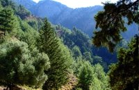 Sfakia, South Hania at 28.6km (W) The Samaria Gorge is one of the longest ravines in Europe (with a total length of 16 km) and offers one of the most spectacular hiking routes in Europe. Its width ranges from 150 m (widest part) to 3 m (narrowest part). The walk from Xyloskalo in the plateau of Omalos to the shores of Libyan sea at Agia Roumeli, takes 6 to 8 hours. The Samaria Gorge has been designated as a national park in order to protect its flora and fauna. It is one of the last shelters of the mountain goat of Crete (Cretan Ibex, common name : kri-kri). The flora is extensive, ranging from high cypress trees to flowers and herbs. The walking path follows the river which flows to small lakes and waterfalls. The Gorge is open to visitors from May to October. Image Library
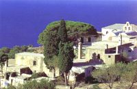 Agios Vassilios, Rethymnon south at 28.7km (SE) It stands 37 km south of Rethimnon, in an imposing landscape which is mentioned at the mid-19th century diary of Th. Spratt (admiral of the British Royal Navy), as "one of the happiest places to withdraw from trials and responsibilities of life".There are lots of legends concerning the foundation of the monastery, which is believed that started during the Venetian occupation of the island. A number of its monks activities made the monastery one of the richest of western Crete and due to its isolated position it played important role in Cretan revolts against the occupying forces. A substantial number of icons and other items is kept in the Museum of the Monastery of Preveli amongst them the miracle - working Eulogistic Cross of Efraim Prevelis.
Image Library
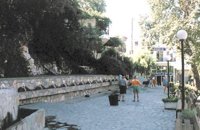 Spili, Rethymno at 29.3km (SE) Spili (GR:Σπήλι) is 30 km away from Rethymnon, along the road that goes from Rethymnon to Armenoi and then Spili. The town has about 800 inhabitants and it lies at a height of 430 m above sea level, at the foothills of Mount Vorizi, which belongs to the Kedros chain. The landmark of the town is the square at Kefalovrissi with the 25 fountains each one in the shape of a lion's head. The square is named after Thanassis Skordalos (1920-1998), a popular lyra player and composer born in Spili. Spili is a modern town, with all the facilities and services required by the locals and by the large number of visitors. Image Library
|
||
|
| ||


C
O
N
T
E
N
T
S
O
N
T
E
N
T
S