interkriti®
YOUR GATEWAY TO CRETE
HOME
CRETE FACTS
NAVIGATE
EXPLORE

Agia Galini
Triopetra
Kissamos
Chryssi Isl.
Agia Marina
Balos
Gavdos isl.
Georgioupolis
SAMARIA
IDA Mtn
Palaiochora
Agia Roumeli
Sfakaki
Bali
Kalamaki
Matala
Lassithi
Plateau Lendas
Tsoutsouros
Vianos
Myrtos
Sfakia
Plakias
Ierapetra
Makrygialos
ZAKROS
Vai
Sitia
Agios Nikolaos
Elounda
MALIA
Hersonissos
Gouves
Chania
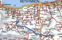
Rethymnon
Heraklion
GORTYN
FESTOS
KNOSSOS
|
|
Crete
List Grid Map
Found
67
- Showing :
41 - 60
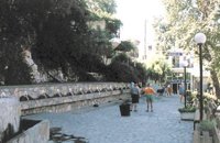
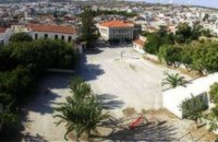 Rethymnon Old Town at 20.1km (NE) The square of Mikrasiaton (GR: Πλατεία Μικρασιατών) formerly the 1st primary school square, in Rethymnon town, covers an area of 7,500 square meters, right at the heart of the city's historical center. It is surrounded by valuable monuments and beautiful buildings, mainly used as cultural centers. There, visitors have the opportunity to rest in a peaceful environment and at the same time visit the various monuments and cultural centers located in the area. Image Library
 Rethymnon Old Town at 20.1km (NE) The Museum of Submarine Life is situated at Arapatzoglou street, at the center of Rethymno's old city. It was founded by the "Moshaki" family, in memory of their lost child, who drowned in the sea. The largest part of the exhibits are made up of shells, while a few vertebrates, sponges and fish are also on display.
 Rethymnon city at 20.1km (NE) The Institute for Mediterranean Studies (IMS) based in Rethymno, Crete, was founded in 1985 and belongs to the research units of the Foundation for Research and Technology, Hellas (FORTH). The IMS is the only FORTH centre which deals with the human and social sciences. The purpose of IMS is to support and invigorate research in the field of the human and social sciences, as well as to promote the application of advanced technologies in the field. The IMS possesses a fully equipped Laboratory of Geophysical-Satellite Remote Sensing (GIS) & Archaeo-environment, specialized in archaeological research. The Library of the Institute is focused on Turkish Studies and Art History. In the Library archival material, as well as collections of Greek and foreign newspapers in digital form and microfilms are kept. The objective of the IMS's research programs is to study the geographical space, the history and culture of Greece and the other Mediterranean countries in various historical periods, from prehistory to modern times. In order to achieve these objectives, the research projects of the Institute are organized along the following axes: Turkish Studies History Studies Art History History of the Theatre - Ethnomusicology The Laboratory of Geophysical-Satellite Remote Sensing & Archaeo-environment Its activities concern the field of geophysical research, the satellite remote sensing, the Geo-information technologies and the archaeo-environment, with emphasis on the Mediterranean region. The Laboratory is a member of international organisations such as EPOCH, EARSel. and AGILE and participates in a number of joint research and technology programs in Greece and abroad (e-Content, INTERREG, ARCHIMED, ETPA, PEWNED, EPEAEK, INSTAP, LIFE, Region of Crete). The research programs of the Institute are carried out by its permanent researchers and collaborating faculty members. In the frame of these research programs are prepared PhD Thesis and other diplomas which are submitted to the higher educational institutions with which IMS collaborates and, particularly, to the University of Crete, the Technical University of Crete and the Technological Educational Institute of Crete. The IMS supports education at post-graduate and post-doctoral level with a considerable number of annual scholarships, thus contributing to attract a steady flow of young researchers and to promote research in the field of humanities at the periphery. The IMS maintains close academic links with various international research foundations (Cyprus, Turkey, Bulgaria, Italy, France, Spain, England, Belgium, Tunesia, Egypt, China, USA, a.o.). The IMS is administered by a director and a five member academic council (A.C.). It is housed in wholly-owned premises comprising of two listed buildings in the old town of Rethymno. The core of one edifice dates back to the Venetian period (13th - 17th century). Links: www.ims.forth.gr/ 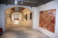 Rethymnon Old Town at 20.2km (NE) The Contemporary Art Museum of Crete was founded in 1992 as Municipal Gallery ‘L. Kanakakis'. It is housed in a Venetian building at the old city of Rethymno, below the Fortezza fortress and the Archaeological Museum. It houses a permanent exhibition of the work of Lefteris Kanakakis (oil paintings, sketches and aquarelles), thus representing all the stages of his achievements, as well as works of contemporary Greek artists, which cover a broad spectrum of modern Greek art as it has been accomplished from 1950 until today. Address: 5, Heimaras Str. 741 00 Rethymno Tel: +30 28310 52530 Website :www.rca.gr 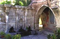 Rethymnon Old Town at 20.2km (NE) A. Rimondi, the Rector of the city, built the famous Rimondi Fountain, which is situated at present day Platanos Square, formerly the centre of Venetian city life, in 1626. The water runs from three spouts in the shape of a lion's head into three sinks. Three small, fluted columns, ornamented with Corinthian capitals are "standing" on the sinks. Above the capitals an entablature can be observed, the middle part of which displays four projections in the shape of the leaves of the acanthus exactly above the columns. Furthermore in this section the words LIBERALITATIS and FONTES are inscribed.
Image Library
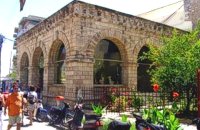 Rethymnon Old Town at 20.3km (NE) Loggia has been built during the 16th century and was designed by the famous architect Michel Sanmicheli. Loggia was an eminent building of the city centre and has been a meeting point for the nobles to discuss political and economical issues. The building is very well preserved; it is square and has arches on its three sides (besides its west side). The consoles of its eaves are spectacular. During the Turkish occupation the loggia became a mosque and a minaret was constructed, which was later demolished in 1930. The past 40 decades the building of Loggia hosted the archaeological museum of the city, which has now moved to a building next to Fortezza. Today loggia hosts a market of archaeological art copies.
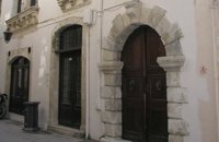
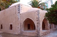 Rethymnon Old Town at 20.3km (NE) The Mosque took its name from the Turkish commander of the marine operations to conquer Rethymno, in 1646. During the Venetian Period, the Mosque became a monastery dedicated to St. Barbara. West from the central building, there is the deserted minaret of the mosque. The fountain of the Mosque is attached to the roofed entrance of the Mosque's garden, where believers washed before entering the Mosque and provided the area with fresh spring water. Image Library
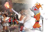 Rethymnon city at 20.3km (NE) In winter the town of Rethymno lives in the rhythm of Carnival. Here, the grandest carnival on the island of Crete is organised. Apart from the great parade on Shrove Sunday, a large number of activities complete the framework of the Carnival festivities. The locals devotedly and cheerfully prepare for this season with creativity, they sacrifice their spare time and become young again while rejoicing and celebrating parties almost on a daily basis. More than 4,000 people have worked feverishly for months in order to present their masks and carriages on the great Carnival parade…The following day, on Shrove Monday people from the countryside play a leading part in the festivities. Unique traditions are revived in the villages and everybody is invited to participate in games, street performances and satires as for example “the kidnapping of the bride”, the “Cadi”, the “smudging of people”. These performances in combination with good wine and the music of the lyre are a successful formula for a unique experience. Links: www.carnivalrethymno.com 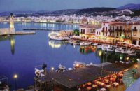 Rethymnon town at 20.4km (NE) Rethymnon old port was of great strategic importance during the Venetian period. It was only able to accommodate small ships. From 1300 until today, the Venetian port has undergone numerous constructions. The 1618 wall that surrounds the port from the east is restored today with some recent interventions and additions. The original lighthouse was constructed during the Turkish period and was later replaced by another one. The building on the southeast part of the port was constructed in 1931 and functioned as a customs office. On the same location it is estimated that there was a quarantine house during the Venetian period. The vaulted spaces on the two or three-floor buildings at the port have been transformed to little and picturesque fish taverns, where visitors can enjoy the secrets of the Cretan cuisine.
 Gavalohori, Vamos, Apokoronas at 20.6km (NW) The exhibition of the objects takes place according to the contemporary museum conception, with explanatory texts, photographs, plans, models, and is enriched with new exhibits every year. The Museum is divided into seven rooms, according to the following units: The Arched House, Silk, Pottery, Lace-making, Masonry and Stone carving, Church and Woodcarving.
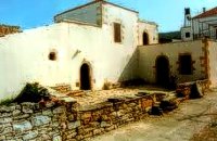
 Apokoronas, Hania at 20.6km (NW) Gavalohóri (GR: Γαβαλοχώρι) is an old big traditional village, with fine examples of traditional rural architecture and stone buildings that are well preserved. The village has been declared a traditional settlement and is awarded a protected status. Many interesting buildings still stand, such as the 18th century olive press, the church of Panagia (Virgin Mary) and that of Agios Sergios, the old school and the complex of the wells from the period of the Venetian occupation.
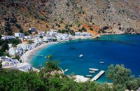 Sfakia, South Hania at 21.1km (W) Loutro is a small village halfway from Agia Roumeli, where the Samarian gorge ends, to Hora Sfakion, accessible only by boat. The majestic scenery, the calm, the crystal clear water and the hospitality of the local people gave Loutro numerous friends and ardent visitors. No cars, no bikes... nothing to spoil the peace of this historical place. Some small hotels, apartments and rooms as well as a few lovely taverns offer their guests a friendly atmosphere that makes Loutro an ideal place for vacation and relax.
 Spili, Rethymno at 21.3km (E) Spili (GR:Σπήλι) is 30 km away from Rethymnon, along the road that goes from Rethymnon to Armenoi and then Spili. The town has about 800 inhabitants and it lies at a height of 430 m above sea level, at the foothills of Mount Vorizi, which belongs to the Kedros chain. The landmark of the town is the square at Kefalovrissi with the 25 fountains each one in the shape of a lion's head. The square is named after Thanassis Skordalos (1920-1998), a popular lyra player and composer born in Spili. Spili is a modern town, with all the facilities and services required by the locals and by the large number of visitors. Image Library
 by Richard Ellis at 21.6km (E) 27th August - I set off from Spili at 0740 under a rather cloudy sky and with a cooling breeze to keep me feeling fresh. Today was always going to be a bit of a road slog and the first few kms to Mixourama was on the main road with cars flashing by. The GPS suggested that there was a road link between Koxare and Agouseliana even though there was nothing on the paper map so, after 6 or 7 kms, I cut across to Koxare. Distance: 32 km Time: 8 hrs. 25mins. Mov av 4.8 km/hr Height overnight: 272m. 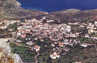 Apokoronas, Hania at 23.1km (N) Kókino Horio (GR: Κόκκινο Χωρίο), which is located at a higher altitude, has maintained its traditional architectural style even more so than the other villages with its narrow roads, beautiful gates and tiled roofs. A group of cisterns, built in a sloping field, gather the rainwater, an interesting example of local architecture, dealing with the permanent problem of lack of water. Above Kokino Horio one can see the strangely shaped hill Drapanokefala or Calapodha (so named during the venetian occupation). The coastline northwest of the village is an extremely interesting place for a stroll due to the ground formation and the caves, such as the cave of Petsi (or Karavotopos). Another cave called Katalimata, located at the centre of the village, is also an interesting site. At cape Drapano, approximately 10 metres under water, is the impressive Elephant cave, an area 60mx60m full of stalactites and stalagmites of various shapes and colours. Video - The Elephants' Cave 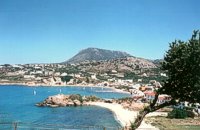 Apokoronas at 23.5km (NW) A beautiful small sea side village with long sandy beach where wind surf, canoes, paddle boats, umbrellas and sun beds can be rented. The place provides all the facilities for the visitors with small hotels, rooms, apartments and many taverns with traditional food and fresh fish. Recent years it became very popular with expatriates and there is a significant development in the real estate sector.
Image Library
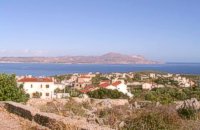 Apokoronas, Hania at 23.5km (N) Pláka (GR: Πλάκα) is a lovely village in the Apokoronas area, less than one kilometer away from Almyrida, with interesting architectural style, which is unfortunately changing due to intense building mainly for tourist purposes. Its ~300 permanent inhabitants, occupying mostly with farming, stock-breeding, fishing and lately with tourism. It has all the basic amenities, including excellent tavernas, bars, a grocery store and a kafeneion. Plaka is built on the slope of a hill at 70 m above sea, with a panoramic view of the bay of Souda. The surrounding environment has maintained its character well and is ideal for walks either inland or along the coast. Visitors can also admire a magical sunset from here. Every summer -at about the end of July- a two days traditional feast - The Plakiana - is organized to honour the memory of the great local lyra player Mihalis Papadakis or else Plakianos. During the feast guests enjoy Cretan dances and can visit the textile and ceramics exhibitions. The custom of Klidonas is celebrated at the end of June and the Carnival usually takes place in March. 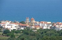 Apokoronas at 25.1km (NW) A flourishing traditional seaside town on the Apokoronas Peninsula 17km east of Hania. Kalýves (or Kalives GR: Καλύβες) with its old tiled stone houses, mixed with the latest buildings form two separate districts, with typical island style. Most of it is literally built on the sea and has 1289 residents. Xydás (GR: Ξυδάς) river that runs through the town, is giving it a unique character and a cool climate that prevents the heat of summer. In the square, you will see a traditional water mill built in the early 20th century, one of the oldest in the area. Kalives is tastefully developed for tourism, and welcomes many visitors during the summer season to its safe sandy beach. With comprehensive amenities, there are many shops, taverns and kafeneion, in addition to banking, post office and petrol station facilities.
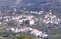
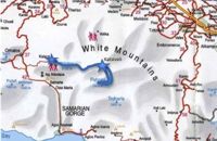 by Richard Ellis at 25.6km (W) 31th August - Katsiveli to Kallerghi via Pachnes- The day dawned with a cloudless blue sky. I was lucky. The route starts with a gentle two km warm up across the Niato plateau before turning more vicious. The next phase is a very steep 700 meter climb up the north east ridge of Kastro. One of the pluses is that you are doing this in the relative cool of the morning - one of the minuses is that you will probably be carrying something like five litres of water. Distance Total (with Pachnes climb): 25.3 km Time: 9 hrs. 30 mins. Mov av 3.3 km/hr Height overnight: 1,518m.(Kalergi) Max. height: 2,453m.(Pachnes) To Pachnes and back:12.1km, time 4hrs 10mins.  Rethymnon North at 26km (NE) Adele village is at a distance of approximately 8 Km east of Rethymnon town located on the road to the Monastery of Arkadi. It is a beautiful small village built in an altitude of 70m above sea level with a population of 350 people. Strolling around the village, through the narrow paved small streets the visitor will come upon beautiful picturesque house yards, freshly whitewashed houses, historical churches and tasteful traditional coffee shops.
|

|
|
|
| ||

;)
;)
;)
C
O
N
T
E
N
T
S
O
N
T
E
N
T
S