interkriti®
YOUR GATEWAY TO CRETE
HOME
CRETE FACTS
NAVIGATE
EXPLORE

Agia Galini
Triopetra
Kissamos
Chryssi Isl.
Agia Marina
Balos
Gavdos isl.
Georgioupolis
SAMARIA
IDA Mtn
Palaiochora
Agia Roumeli
Sfakaki
Bali
Kalamaki
Matala
Lassithi
Plateau Lendas
Tsoutsouros
Vianos
Myrtos
Sfakia
Plakias
Ierapetra
Makrygialos
ZAKROS
Vai
Sitia
Agios Nikolaos
Elounda
MALIA
Hersonissos
Gouves
Chania
Rethymnon
Heraklion
GORTYN
FESTOS
KNOSSOS
|
|
Crete
List Grid Map
Found
117
- Showing :
21 - 40
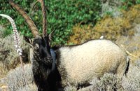 Cretan Ibex, Lefka Ori, Hania at 18.9km (NW) Kri-Kri is the common name of the Cretan feral goat (Capra aegagrus ssp. cretica) which is the largest wild mammal on the island. Its grandeur, its bravery, its ability to observe without being noticed, its speed and its impressive horns are the features that were loved by the locals and made it a symbol of Crete and the untamed Cretan spirit. It lives mainly on the White Mountains and its local name is "Agrimi" (GR: Αγρίμι = the wild one) for the male and "Sanada" (GR: Σανάδα) for the female. Recent years, young kri-kris have approached the old village of Samaria, where they are fed by the park rangers and can be seen by the visitors. Kri-kris and goats are close genetically, as the hybridization that exists between them show. Kri-kri's size however is a good deal larger than that of a goat Kri-kris have a strong sexual dimorphism. Males are larger than females. They all have horns, with annual rings and knobs, from which their age can be easily calculated. Males have larger horns than females (up to 90 cm), which curve backwards. An other characteristic of the males is the beard, which rarely occurs in females. Their coat is short and brown in summer and brownish and denser in winter. They have a black line on the back, which extends from the neck to the top of the tail while at its shoulders the line intersects with another one that reaches the stomach. There are also black patterns on the front parts of their legs. There are numerous representations of Kri-kris on ancient sealstones, vases and coins, indicating the esteem in which they were held by the people of antiquity. Phototograph by Anastassios Sakoulis - www.photophysis.gr Image Library
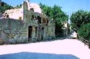
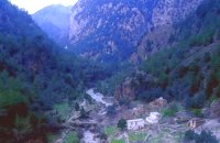 Samaria National Park at 18.9km (NW) The deserted village of Samariá (GR: Σαμαριά) is located in the middle of the gorge of Samaria, 7.5 km away from Xyloskalo and 8.5km fro Agia Roumeli. This is the main resting point for the gorge walkers coming down from Omalos. There is a fountain with fresh drinkable water from the spring, benches and some tables, in the shade of tall plane trees where the visitors can relax and have some food (Only if they carry it with them). The village of Samaria was abandoned in 1962, when the area declared a National Park. The main occupations of its inhabitants were the wood cutting and bee keeping. Opposite the village are the old olive trees cultivated mainly for the residents' own consumption. Some of the village' s ruined housed are restored and are used today by the gorge authorities. One houses the guards' post, another the doctor's office and a third - the old olive mill - houses the information kiosk of the park where the visitors can view old pictures and folk art exhibits. Kri - kris (the Cetan Ibex) make their appearance here from time to time especially the young ones which are less shy. At the village's edge lies the byzantine church of "Osia Maria of Egypt" (Osia = Saint). The name Samaria is believed that is a corruption of the words "Osia Maria" or "Santa Maria". A little before the village (coming from Xyloskalo) in a small clearing lies the small church of Agios Geórgios. Image Library
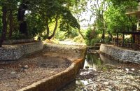
 Apokoronas, Hania at 19.4km (NE) Crete's only freshwater lake, Lake Kournás (GR: Λίμνη Κουρνά), is relatively large, with a perimeter of 3.5 km. Although almost all touristic leaflets say that it is possible to walk around the lake, that is not true. At least not at the end of the rain season (winter). There is a nature preserve on the Southwest of the lake. But there is a rustic road from the North of the lake to the Hills on the West of the lake too. Image Library
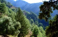 Sfakia, South Hania at 20.1km (NW) The Samaria Gorge is one of the longest ravines in Europe (with a total length of 16 km) and offers one of the most spectacular hiking routes in Europe. Its width ranges from 150 m (widest part) to 3 m (narrowest part). The walk from Xyloskalo in the plateau of Omalos to the shores of Libyan sea at Agia Roumeli, takes 6 to 8 hours. The Samaria Gorge has been designated as a national park in order to protect its flora and fauna. It is one of the last shelters of the mountain goat of Crete (Cretan Ibex, common name : kri-kri). The flora is extensive, ranging from high cypress trees to flowers and herbs. The walking path follows the river which flows to small lakes and waterfalls. The Gorge is open to visitors from May to October. Image Library
 Apokoronas, Hania at 20.1km (N) The traditional little village of Vrisses lies approx. 35 km from Chania town. The old village square with its tall plane trees, the tavernas and kafenions is the perfect place to relax and enjoy the lush green landscape by the river Vrissanos and taste the renowned and particularly delicious local yogurt.
 by Richard Ellis at 20.1km (NE) 28th August - Because we had researched this bit in May, it wasn't so daunting to leave the tarmac-bound E4 and to launch off uphill to make the old crossing (not yet on any map) between here and Askyfou. The first gully climb up to 3,300 ft was quite straight forward as we had done it before. Distance: 22.4 km Time: 8 hrs. 35mins. Mov av 3.7 km/hr Height overnight: 714m. 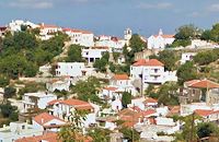 Rethymnon North at 20.2km (NE) A beautiful small town in the county of Rethymno with great views, natural water springs and lush vegetation. It's located at 260m a.s.l. between the rivers "Mousselas" and "Petres", 22km from the national road and 5km from Episkopi. Argiroupolis is the site of the ancient city of Lapa.
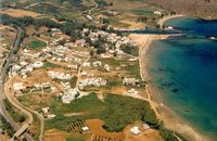 Apokoronas, Hania at 21km (NE) Georgioupolis lies at the northern coast of Crete, about 35km away from Hania and 20 km from Rethimno. It is a nice coastal village situated at the bay of Almiros, in a lovely green scenery. It has a sandy beach and attracts quite a few visitors in the summer time. It provides all the necessary facilities to the tourists.
 Rethymnon at 22.4km (NE) Zouridi is a village of the county of Rethymno, located 19,5 km away from the city, built at 260m a.s.l. with 90 inhabitants. Here excavations unearthed findings from the post palace period, and the Roman period as well as many venetian houses. Nowadays the village is characterized as a preservable settlement, and buildings such as the old high school are going to be restored.
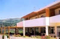
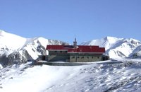 Lefka Ori, Hania at 22.8km (NW) Kallérgi Mountain Refuge is located on the western region of Crete, above the plateau of Omalos, in the White Mountains (Lefka Ori) mountain range at an altitude of 1680 metres. The site is of unique natural beauty and commands great views to the surrounding peaks and the gorge of Samaria. It can be accessed by car or on foot (1 1/2 hour) via the 5km long dirt road from Omalos. The refuge can accommodate up to 50 people. It features a fully equipped kitchen, a lodge with fire place and wood burning stoves, toilets (indoors and outdoors) and a camping area. Electricity is supplied by a generator. Kalergi refuge operates throughout the year (from November to March only on weekends) For more information please visit:Mountaineering Club of Hania 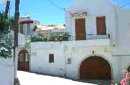 Rethymnon North at 22.9km (NE) Episkopi is a small town of the prefecture and county of Rethymno. It is located at the old national road of Rethymno - Hania, 17 km away from the city of Rethymno. The town is built at 120 m a.s.l. overlooking the northern coast of Crete, and the green and fertile valley of Mousselas river.
 by Richard Ellis at 22.9km (NW) 1st September - The last two days of the walk were rather low key after the drama of the White Mountains. I left Kallerghi at 0800 after a proper Austrian mountain breakfast served up by my new Bulgarian friend Daniel. It is about an hour down the dirt road to the Omalos plateau and half way down I realised I had left my beloved katsouna (shepherd's crook) at the hut. I couldn't bear the prospect of going all the way back up so I rang Joseph to say that I would collect it the following week. I have learnt that it is now forbidden to cut sticks from the wood of the rare ambelitsia tree so mine is now a museum piece (with the distinction of having walked 450 kms across Crete). Distance: 28.4 km Time: 8 hrs. 20 mins. Mov av 4.2 km/hr Height: 405m.  Omalos, Hania at 23.1km (NW) Xylóskalo (Ksyloskalo GR: Ξυλόσκαλο) is the point where the Samarian gorge starts. It is located on the Lefka Ori (White Mountains) in the plateau of Omalos, 43 km from the city of Hania at 1250m above sea level. It is also the entrance to the gorge. There are two tourist lodges where visitors can rest and have food or coffee and take panoramic pictures of the gorge and the White Mountains. There is also the information center of the National Park and a parking area. Xyloskalo means the "wooden stair" and refers to a wooden staircase built by the locals in order to facilitate the entrance to the gorge as at this point the cliffs are very steep. Today this part of the path is made of stones and it has a wooden handrail. About 1km before Xyloskalo a dirt road leads, after 5 km, to the Kallergis mountain lodge at 1680m a.s.l. 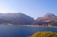 Agios Vassilios, Rethymno (South) at 23.2km (E) A sea side village, 40 km south from Rethimno, with 237 permanent residents, built at the cove of the bay of the same name on a wonderful sandy beach, 1300 m long, between the capes Stavros and Kako Mouri, that is ideal for swimming and sea sports. The natural beauty of the place helped Plakias to become a renowned tourist resort now providing all the facilities that a visitor could wish. It belongs to the municipality of Finikas.
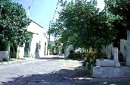
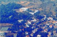 Apokoronas, Hania at 23.3km (N) Vámos (GR: Βάμος) is the capital of Apokoronas district is an exceptionally interesting village that the Ministry for the Environment, Physical Planning and Public Works has classed as traditional. It is more like a small town, very well preserved, with folk and neoclassical architectural elements. The initiative of a group of inhabitants to create an association for the preservation of the village as well as alternative tourism strategies is already paying off while constituting a model for further local progress. The famous art and cultural festivals are good opportunities for everyone to experience the hospitality and entertainment Vamos can offer.
 Rethymnon at 23.3km (NE) The village stands 17km away from Rethymno and 6km from Episkopi. It has 160 inhabitants, farmers and stock breeders. The first university of Crete, called VIVI'S ACADEMY operated here in 1540 AD. There are remnands of many Venetian Houses, such as Villa Barocci, a mint, a fountain etc.
 Kanevos, Agios Vasslios at 23.9km (E) At the beautiful small village of Kanevos on the road from Rethimno to Plakias, a little before the imposing gorge of Kotsifos you will find Iliomanolis tavern. Mrs Maria an experienced cook, will offer you her best specialties made with fresh pure Cretan products, and your lunch, breakfast or dinner will be one of the most pleasant experiences in Crete.  Apokoronas, Hania at 25.2km (NE) The community of Kefalas (GR:Κεφαλάς) is situated in Apokoronas, Hania, approximately 4 km to the east of Vamos. During the Venetian occupation higher and lower Kefalas were classed as two separate villages, however, today they have become one. It is a large village built in an outstanding position facing the sea with architecture dominated by the influence of the early and late years of the Turkish occupation. This influence is well preserved despite the existence of other architectural styles. The church of Timios Stavros (16th century) is the oldest building of the village while the more recent churches of Panagia, Agios Antonios, and Michael the archangel, works of the reputed Kefalas craftsmen, are examples of folk architecture of the 19th century. A further example of the work of the same craftsmen is the Public School of Kefalas, which in accordance with the decision of the county council of Hania will house the Environmental Educational Centre of the prefecture, a foundation that will play a definitive role in the development of the municipality of Vamos. Other interesting communities are Paleloni and Drapanos in the direction of Kokino Horio. The road from Paleloni leads to Embrosgialo, a relatively easily accessible place, along the steep coastline, which extends to Georgioupoli. 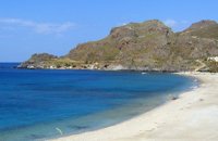 Agios Vassilios, South Rethymnon at 25.4km (E) One of the nicest sandy beaches of Crete Damnoni is around 6km to the east of Plakias. There are some facilities like umbrellas, sun beds and sea sports and a couple of taverns for drinks and food. Accommodation is also available. Within walking distance to the east there are two smaller beaches nested in small coves. A little farther is the beach of Shinaria which is very popular with the divers.
Image Library
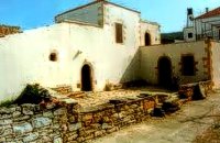 Gavalohori, Vamos, Apokoronas at 25.6km (N) The exhibition of the objects takes place according to the contemporary museum conception, with explanatory texts, photographs, plans, models, and is enriched with new exhibits every year. The Museum is divided into seven rooms, according to the following units: The Arched House, Silk, Pottery, Lace-making, Masonry and Stone carving, Church and Woodcarving.
|
||
|
| ||


;)
;)
;)
C
O
N
T
E
N
T
S
O
N
T
E
N
T
S