interkriti®
YOUR GATEWAY TO CRETE
HOME
CRETE FACTS
NAVIGATE
EXPLORE

Agia Galini
Triopetra
Kissamos
Chryssi Isl.
Agia Marina
Balos
Gavdos isl.
Georgioupolis
SAMARIA
IDA Mtn
Palaiochora
Agia Roumeli
Sfakaki
Bali
Kalamaki
Matala
Lassithi
Plateau Lendas
Tsoutsouros
Vianos
Myrtos
Sfakia
Plakias
Ierapetra
Makrygialos
ZAKROS
Vai
Sitia
Agios Nikolaos
Elounda
MALIA
Hersonissos
Gouves
Chania
Rethymnon
Heraklion
GORTYN
FESTOS
KNOSSOS
|
|
Crete
List Grid Map
Found
90
- Showing :
21 - 40
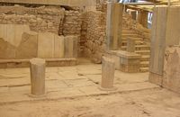 Phaistos Palace at 2.9km (NE) The southernmost of the "Royal Apartments" ofPhaistos has been identified as the Queen'sMegaron. It consists of a beautiful, spacioushall with a double colonnade opening ontoa light-well. The floors are paved with gypsum slabswith red plaster filling the interstices. Gypsumwas also widely used for the benches runningaround the walls of the Megaron and the facingof the lower part of the walls. The upper walls aredecorated with frescoes depicting plant motifs. Twobeautiful rhyta (libation vessels) were found here: one is decorated with the cult symbols of thedouble axe and sacral knot, while the other bears areed pattern. The two staircases to west and north led to the upper floorof the Megaron and the peristyle, where one of the mainentrances to the "Royal Apartments" was located. Image Library
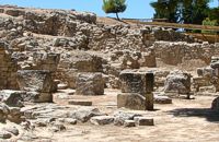 Phaistos Palace at 2.9km (NE) The complex of four rooms on the northeast edge of the Palace does not belong to the Old Palace, although it directly adjoins it. In the westernmost building is an elongated rectangular room with partitions of vertical clay slabs. Similar "cists" in the Palaces of Knossos and Zakros were used to store valuable ritual vessels. Here they were found empty. Next door, in the narrow rectangular room to the southeast, was found a clay tablet inscribed in Linear A and the famous "Phaistos Disc" bearing hieroglyphic writing. The building was therefore named the Palace "Archive" The building east of the Archive is thought to be a shrine or the archivist's residence, while the easternmost building is known as the "Potter's Workshop" because a large number of unfinished pots were found there. The intermediate building has an impressive peristyle of alternating pillars and columns. A staircase on the south side of the peristyle building connects the whole complex to the NE entrance to the Palace, which stood in this spot. Image Library
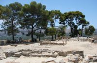 Phaistos Palace at 2.9km (NE) The east part of the North Wing forms the workshop area of the Palace. It consists of the East Court and a complex of small rooms which are believed to be the workshops of the New Palace (1700-1450 BC). Approximately in the centre of the court are the ruins of a horseshoe-shaped kiln. The elongated rectangular building with 6 rooms on the west side of the court appears to have been used for the workshops of the kiln craftsmen. The square room on the north side of the court was the gatehouse of the northeast entrance to the Palace. It has gypsum slab flooring and benches around the walls. Behind it is a long corridor leading to the inner courtyard of the North Wing and thence to the "Royal Apartments" Image Library
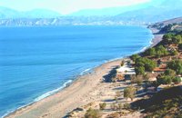 Messara Bay, Iraklion at 3.6km (SW) One of the most beautiful sandy beaches of Crete, extends from a clump of rocks riveted in the shallow waters in the south to the Kalamaki settlement in the North. In Minoan times there used to be the ancient port of Phaistos. The antiquities lie just a few meters away from the sea.
Image Library
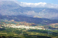
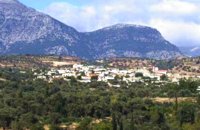
 Messara, Iraklion South at 4km (NE) Vori is a beautiful, traditional village of the county of Pirgiotissas in the Messara Valley. It is located 60 km south of Iraklion and in the western part of the Messara Valley. The village stretches in a slope, by the side of a small river. The archaeological site of Phaistos is 2 km to the south and the coast of Messara 4 km to the west.
 Voroi, Messara, Iraklion at 4.3km (NE) The exhibited objects in the Museum come from all over Crete. These objects show that the folk culture of Crete is characterized by an amalgam of influences in which Minoan (2000-1000 BC), Archaic (1000-500 BC) and Byzantine models prevail, especially in agriculture, stock breeding, pottery and basketry.
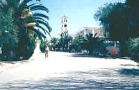 Moires, Messara at 4.3km (NE) The monastery of Panagia Kaliviani is located at the 59th km on the road Iraklion-Phaistos. The monastery was built during the second Byzantine period. The small Byzantine chapel was painted with frescoes but most of them are today destroyed. The chapel was deserted until, during the Turkish occupation in 1873, an old small icon of the Annunciation of the Holy Mother was miraculously found there.and the monastery became a place of worship. 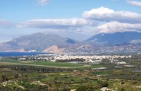 Messara, Iraklion South at 4.6km (NW) The town of Timpaki (GR: Τυμπάκι) is located in the west edge of the plain of Messara, 65.3km away from the city of Iraklion. It is a rich and busy town with significant economic activity especially due to the early vegetables production in the wider area. There are banks, a post office, medical centers, stores, schools, hotels, restaurants, ect to cover both the needs of the locals and visitors.
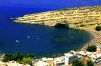 Messara, South - West Iraklion at 5.8km (SW) Matala (GR: Μάταλα) was the ancient port of Phaistos and Gortys and a former fishing community which has developed into a modern holiday center. It is located 4 km south-west of the village of Pitsidia and 75 km from Iraklion. It is built on the coast line of the Messara bay inside a small and picturesque inlet. During the 60's the caves of Matala were hosting a hippie commune.
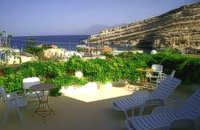 Matala at 5.8km (SW) We at Die Zwei Brueder (The Two Brothers) offer you nice, clean rooms. Although it's only two minutes walk to the beach or to the village, the pension's unique high placing guarantees you peace whenever you want it. Also help with information and car rentals to our customers. Find also villas for rent in the area. Villas Panorama and Peristeri are situated in the village of Pitsidia very close to Matala, Kommos and Kalamaki. They offer high standards' accommodation and one has its own swimming pool. 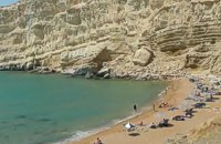 Matala, South - West Iraklion at 6.4km (SW) The Red beach is located around 700m south from Matala. It is a beautiful secluded beach with fine reddish sand originating from the rocks of the area. The name "Red Beach" is given by the visitors due to its reddish color while its original name is Ammoúdia (GR: Αμμούδια). The sea gets a lovely blue-green color, making the landscape really unique. The only way to access Red Beach is on foot or by boat from Matala. The walk from Matala takes about 20 minutes and it can't be considered as an easy one. Red Beach however can get pretty crowded in the high season. There is a small stone-wall canteen offering snacks and drinks and a few umbrellas and sun-beds. Nudism is tolerated at the two ends of the beach. Image Library
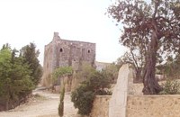 Messara plain, South - East Iraklion at 6.7km (S) The monastery of Odigitria is a monastery of great importance and historical value and one of the oldest in Crete. It is located at the west edge of the Asterousia mountains at an altitude of 250 m. The monastery was surrounded by walls, part of them still stands. The temple of the monastery is dedicated to the assumption of Holly-Mother and to the Saint Apostles (Peter & Paul). Inside the temple there are valuable frescoes, icons of famous painters and iconostasis. The monastery is connected with the legendary freedom fighter 'Ksopateras' (1788 - 1828) In the area of the monastery at Agioi Eftihianoi was found an ancient (Early Minoan) cemetery. 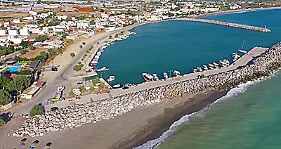 Messara bay, Iraklion South at 7.4km (NW) Kokkinos Pirgos (GR: Κόκκινος Πύργος) is a small coastal community, 2km away from Timbaki with a nice, long sandy beach, one of the longest in Crete, and a clear transparent sea. The part of the beach to the north west of the harbour is called Makrimaliana (or Kakoskalo) and the south east part of it is called Katalyki . The harbour in front of the village of Kokkinos Pirgos, offers docking facilities for sailing and fishing boats. There are hotels, restaurants, bars, etc. across the harbour and along the beach. You can always find good fresh fish in the taverns of the village. Kokkinos Pirgos (meaning red tower) , took its name from a castle that use to be there during the Middle Ages, which was built by red clay earth.
Image Library
 Messara plain, South - East Iraklion at 7.8km (E) The administrative center of the Messara Valley. Moires (GR: Μοίρες) is the biggest town in the Messara Valley with a population of approximately 5000 people. It has a police station, magistrate's court,post office, public PTT office, health center, and offices of most Greek major banks.
 Messara, Iraklion South at 8.6km (NE) Gallia is one of the oldest villages of the area. It is mentioned as a location in the Venetian records as early as 1577, and as a village with 120 residents since 1583. The renaissance tower in the village (still imposing although rundown) and the water fountains in the Kapeloniana area are proof of the passing of the Venetians. Part of the village, called Monohoro, is mentioned as early as 800 A.D.  Mires, Messara Valley at 9.6km (NE) It is located north of Mires close to a small gorge, with springs and covered with trees. There are many churches in the village the most important one being the church of Agios Nikolaos, a domed church dated to the 13th century. The walls of the temple are hand painted with biblical scenes and pictures of saints
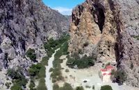
 South - coast Iraklion at 11.3km (S) Martsalo (GR: Μάρτσαλο, Mártsalo) is located on the mass of the Asterousia Mountains between Kefali (Cape Lithino) and Agiofarago. It is an impressive gorge about two kilometers long, which belongs to the hermitages of the Holy Monastery of Odigitria. Inside the gorge there is rich vegetation as well as a small palm forest in the middle of its route. The impressive cliffs are home to a large number of caves (similar to eagles' nests) inhabited by many of the area's ascetics. Gorge Martsalo is particularly steep and rough and ends at the Libyan Sea, where there is a small protected cove with a sandy- pebbly beach. Image Library
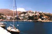 South Rethymnon at 11.7km (NW) A seaside town of the municipality of Agios Vassilios. It is a well organized tourist resort with comfortable hotels, apartments, camping sites, tourist agencies, car-renting offices, restaurants, tavernas and other recreation centres, as well as all the facilities required by tourists and locals alike. There is also a port and port - custom authorities.
Image Library
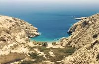
 South - coast Iraklion at 11.9km (S) Agiofaraggo (GR: Αγιοφάραγγο the gorge of Saints) is a small gorge at the southern shores of Heraklion close to the village and the beach of Kaloi Limenes and 6 kilometers south of the Monastery of Odigitria. Image Library
 Voriza, South - West Iraklion at 13.5km (NE) Close historical bonds link this monastery to that of Vrontisiou. The Varsamonerou Monastery lies in the surrounding fields of the village Voriza, 54.5 kms from Heraklion. The monastery is abandoned and, though its cells have been destroyed, its church has some of the most remarkable wall paintings in Crete.
|
||
|
| ||


C
O
N
T
E
N
T
S
O
N
T
E
N
T
S